 |
|
ICAO Code EDLA
Name ARNSBERG-Menden
Land Deutschland
Bundesland Nordrhein-Westfalen
Letzte Änderung 23. Juli 2003
Kategorie Verkehrslandeplatz / Public Airfield
Betreiber / Operator Flugplatzgesellschaft Arnsberg-Menden mbH
Adresse Hüingser Ring 52
ZIP / City D-58710 Menden
Fon +49 (02373 / 891615, 01726077140
Fax 941503
Internet Nein
Lage / Location 2.95 NM NW Neheim-Hüsten
Nachtflug / NVFR NVFR
LFZ / ACFT Bis / up to 5700 kg, HEL 6000 kg
Helicopter Ja / Yes
Motorsegler / GLDP Ja / Yes
Ballone Ja / Yes
UL PPR
Summer Mo-Fri 0600-SS/1800, SAT, SUN, HOL 0800-SS/1800
Winter Mo-Fri 0700-SS/1900, SAT, SUN, HOL 0900-SS/1900
O/T PPR
Keine platzrundenflüge Sun+HOL sowie Sat ab 1200 (1100) Überlandflüge
von weniger als 60 MIN sind nicht zulässig, EXC Werkstattflüge
der ansässigen Werft./No flights in the traffic ciruit Sun+HOL and
Sat after 1200 (1100) Cross-country flights of less than 60 Min duration
are not permittet EXC test flights from the hangar on location. Weitere
Einschränkung siehe AIP AD 1-6 / restrictions see AIP AD 1-6
Luftaufsicht / OPS +49 (0)2377 / 580, 3066, Fax 4866
PPR +49 (0)2372 / 62511, 01702062510, +49 (0)2377 / 4818
AIS AIS-Centre EDDZ, +49 (0)69 / 78072500
ACC EDDL +49 (0)6103 / 7076600 / 6601
MET (0190) 077223
Gafor 36
Zoll / Customs Während der Betriebszeit/During poerating hours zur
Personen beförderung im nichtgewerblichen Verkehr oder im Gelegenheitsverkehr/
for the transport of passengers in non-commercial or non-scheduled traffic.
Zoll / Customs Fon +49 (0)2377 / 580, 3066
Fuel 100 LL, Jet A1, super Plus DIN EN 228
Oil 80, 100, D 80, D 100, Turbo Oil, 15 W 50
Hangar Beschränkt / Limited PPR
Höhe / Elevation 794 ft / 242 m
FIS Langen Information 129.875
VDF / QDM 123.025, 122.500
Rufzeichen / Call sign Arnsberg INFO
Frequenz Tower 123.025 GE, 122.500 GE
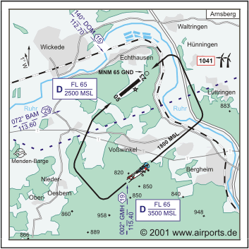
NAV Aids 140°/18 NM from DOM 112.70 - 002°/19 NM from GMH 115.40
- 072°/29 NM from BAM 113.60
Koordinaten 51 29, 00 N / 07 53, 96 E
Platzrunde / Traffic circuit
Landebahnen / RWY 1
RWY 920 x 20 m, ASPHALT
RWY 05 TKOF 920 m; LDG 920 m
RWY 23 TKOF 920 m; LDG 920 m
MTOW 5700 kg, HEL 6000 kg
Bemerkungen / Remarks An/Abflüge grundsätzlich von/nach Norden/
APCH/DEP generally from/to the north. Für GLD nicht zugelassen! Wohngebiete
meiden! PPR 3000 bis 5700 kg MPW!
Restaurant - Yes
WWW: http://www.airports.de/airport.php?ICAO=EDLA
Images and information placed above are from
http://www.airports.de/airport.php?ICAO=EDLA
We thank them for the data!
| General Info
|
| Country |
Germany
|
| ICAO ID |
EDLA
|
| Time |
UTC+1(+2DT)
|
| Latitude |
51.483333
51° 29' 00.00" N
|
| Longitude |
7.899333
007° 53' 57.60" E
|
| Elevation |
794 feet
242 meters
|
| Magnetic Variation |
000° E (01/05)
|
| Beacon |
Yes
|
| Operating Agency |
CIVIL GOVERNMENT, (LANDING FEES AND DIPLOMATIC CLEARANCE MAY BE REQUIRED)
|
| Operating Hours |
SEE REMARKS FOR OPERATING HOURS OR COMMUNICATIONS FOR POSSIBLE HOURS
|
| Daylight Savings Time |
Last Sunday in March to last Sunday in October
|
| Communications
|
| INFO |
122.5
123.025
|
| LANGEN INFO |
129.875
|
| Runways
|
ID
|
Dimensions |
Surface |
PCN |
ILS
|
| 05/23 |
3018 x 66 feet
920 x 20 meters |
ASPHALT |
- |
NO
|
| Supplies/Equipment
|
| Fuel |
Jet A1, without icing nhibitor.
100/130 MIL Spec, low lead, aviation gasoline (BLUE)
|
| Remarks
|
| CSTMS/IMG |
Avbl.
|
| FUEL |
(NC-100LL, A1)
|
| OPR HOURS |
Opr 0700-SS/1900Z++ Mon-Fri; 0900-SS/1900Z++ Sat, Sun, hol; OT PPR.
|
| RSTD |
Arr/dep S rqr INFO apvl.
|
Runway 05/23
3018 x 66 feet
920 x 20 meters
| Runway 05
|
| Surface |
ASPHALT
|
| True Heading |
050.0
|
| Latitude |
51.481086
51° 28' 51.91" N
|
| Longitude |
7.895025
007° 53' 42.09" E
|
| Elevation |
793.0 feet
242 meters
|
| Slope |
-1.0°
|
| Landing Distance |
3018 feet
920 meters
|
| Takeoff Distance |
3018 feet
920 meters
|
| Lighting System |
MIRL
|
| Runway 23
|
| Surface |
ASPHALT
|
| True Heading |
230.0
|
| Latitude |
51.486386
51° 29' 10.99" N
|
| Longitude |
7.905189
007° 54' 18.68" E
|
| Elevation |
762.0 feet
232 meters
|
| Slope |
1.0°
|
| Landing Distance |
3018 feet
920 meters
|
| Takeoff Distance |
3215 feet
980 meters
|
| Overrun Length |
197 feet
60 meters
|
| Overrun Surface |
ASPHALT
|
| Lighting System |
MIRL
|
The content above was published at Airports-Worldwide.com in 2005.
We don't guarantee the information is fresh and accurate. The data may be wrong or outdated.
For more up-to-date information please refer to other sources.
|
|


