|
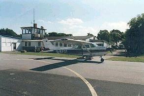
Baltic Sea Airport
Sightseeing flights and flights for taking photos
 Enjoy our attractive countryside from the bird’s
eye view. An experience that is guaranteed to leave behind lasting impressions.
Enjoy our attractive countryside from the bird’s
eye view. An experience that is guaranteed to leave behind lasting impressions.
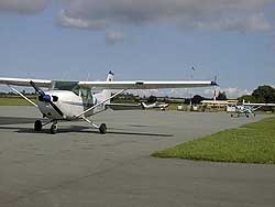
Sightseeing flights can be planned and flown from Barth. Four-seater
of Cessna 172 airplanes are available, which are particularly suitable
for taking a look out as the wings are on the top of the plane. Three
adult passengers or two adults and two children up to 10 years of age
can join in the flight. All the prices below apply to the airplane, irrespective
of the number of passengers.
We carry out sightseeing flights to the destination of your choice. The
air fare will be calculated according to the flight time required. Flights
with stopovers are possible as well with prior agreement.
HISTORY:
1936 Fertigstellung des Flughafens Barth
1957 - 1975 Verkehrsflughafen (1971 76.000 Passagiere)
1975 - 1990 Agrarflugplatz
1990 23.01. 1."Luftmauerdurchbruch"
erste Landung eines Luftfahrtzeuges der Allgemeinen Luftfahrt (Aero-Club
Hamburg)
18.03. Landung des ersten Passagierflugzeuges mit Otto Graf Lambsdorf
27.09. Wiederzulassung als Flughafen der Flughafen GmbH Ostsee und die
Eröffnung des internationalen Verkehrs durch Flüge aus London,
Oslo, Paris, Trelleborg und Malmö
1991 01.07. Gründung der Ostseeflughafen Stralsund-Barth GmbH
1993 2. Ausbaustufe
1994 Anflugbefeuerung Startbahn 27
1995 Instrumentenanflug NDB-DME
1995 Luftraum F
ICAO Code EDBH
IATA Code BBH
Name BARTH
Land Deutschland
Bundesland Mecklenburg-Vorpommern
Letzte Änderung 3. April 2003
Kategorie Verkehrslandeplatz / Public Airfield
Betreiber / Operator Ostseeflughafen Stralsund-Barth GmbH
Adresse Flughafen
ZIP / City D-18356 Barth
Fon +49 (0)38231 / 89551, 2503,
Fax 2480
Internet Nein
Lage / Location 1.6 NM S Barth
Nachtflug / NVFR NVFR
Instrumentenflug / IFR IFR
Helicopter Ja / Yes
Motorsegler / GLDP Ja / Yes
Segelflugzeuge / GLD Ja / Yes
UL Ja / Yes
Fallschirmspringen / PJE Ja / Yes
PCN 30 F/A/X/T, PPR für LFZ über 5700 kg bis 1600 des vorherigen
Werktags. / PPR for ACFT above 5700 kg until 1600 of preceeding workday.
Summer MON-FRI 0600-1600 SAT, SUN, HOL 0700-1600, MON-SUN 1600-1800 O/R
(bis/until 1500)
Winter 0800-SS/1700, SS-1900 O/R (bis/until 1400)
O/T PPR
Luftaufsicht / OPS +49 (0)38231 / 2503, 89551, Fax 89554
AIS EDDB +49 (0)30 / 60918250
MET (0190) 077222
Gafor 11
Zoll / Customs O / R 2 HR vorher/before
Zoll / Customs Fon +49 (0)38231 / 2503
Fuel 100 LL, Jet A1
Oil 80/100, 20W50
Hangar PPR
Höhe / Elevation 22 ft / 7 m
FIS Berlin Information 126.350
Rufzeichen / Call sign Barth Info
Frequenz Tower 118.075 GE
NAV Aids BHD Ch 101/115.40 am Platz/at Field - 089°/0.6 NM from BTH
373 - 240°/22 NM from TRT108.45/ - 318°/46 NM from FLD 115.60
Koordinaten 54 20, 29 N / 12 42, 60 E
Platzrunde / Traffic circuit S 800
Landebahnen / RWY 2
RWY 1200 x 30 m, ASPHALT
RWY 09 TKOF 1150 m; LDG 1200 m
RWY 27 TKOF 1150 m; LDG 1200 m
MTOW PCN 30 F/A/X/T
RWY II 900 x 40 m, Gras
RWY 09 TKOF 900 m; LDG 900 m
RWY 27 TKOF 900 m; LDG 900 m
MTOW RWY II 2000 kg
Bemerkungen / Remarks Airspace F! (GND/2500 MSL) HX! Ortschaft Barth nicht
überfliegen! GLD + PJE! UL- Betrieb! * GRAS RWY : PPR!
Restaurant - Yes
Kontakt:
Ostseeflughafen
Stralsund-Barth GmbH
Flughafenallee
18356 Barth
Tel.: 038231-89551
Fax: 038231-2480
E-mail: flughafen-barth at t-online
de
WWW: http://www.ostseeflughafen-stralsund-barth.de/
Images and information placed above are from
http://www.ostseeflughafen-stralsund-barth.de/
http://www.stadt-barth.de/tourismus/e_flugplatz.html
http://www.airports.de/airport.php?ICAO=EDBH
We thank them for the data!
| General Info
|
| Country |
Germany
|
| ICAO ID |
EDBH
|
| Time |
UTC+1(+2DT)
|
| Latitude |
54.338175
54° 20' 17.43" N
|
| Longitude |
12.710106
012° 42' 36.38" E
|
| Elevation |
23 feet
7 meters
|
| Type |
Civil
|
| Magnetic Variation |
002° E (01/05)
|
| Beacon |
Yes
|
| Operating Agency |
CIVIL GOVERNMENT, (LANDING FEES AND DIPLOMATIC CLEARANCE MAY BE REQUIRED)
|
| Operating Hours |
SEE REMARKS FOR OPERATING HOURS OR COMMUNICATIONS FOR POSSIBLE HOURS
|
| Daylight Savings Time |
Last Sunday in March to last Sunday in October
|
| Communications
|
| BERLIN RADAR |
126.425
|
| INFO |
118.075
|
| BERLIN INFO |
126.35
|
| Runways
|
ID
|
Dimensions |
Surface |
PCN |
ILS
|
| 09/27 |
3937 x 98 feet
1200 x 30 meters |
ASPHALT |
030FAXT |
NO
|
| 09L/27R |
2953 x 131 feet
900 x 40 meters |
GRASS OR EARTH NOT GRADED OR ROLLED. |
- |
NO
|
| Navaids
|
| Type |
ID |
Name |
Channel |
Freq |
Distance From Field |
Bearing From Navaid
|
| NDB |
BTH |
BARTH |
- |
373 |
At Field |
-
|
| DME |
BHD |
BARTH |
101X |
- |
At Field |
-
|
| Supplies/Equipment
|
| Fuel |
Unknown fuel type or whether there is any fuel.
|
| Remarks
|
| CSTMS/AG/IMG |
CSTMS, IMG avbl O/R 2 hr ntc fone C(038231) 2503. No entry fr non-EUR countries.
|
| FUEL |
(NC-100LL, A1) Refuelling not avbl with Carnet. EC and credit cards accepted.
|
| NS ABTMT |
Avoid ovft of village of Barth.
|
| OPR HOURS |
Opr 0800Z-SS/1700Z; SS-1900Z O/R (req must be made NLT 1400Z); OT PPR. (0600-1600Z Mon-Fri; 0700-1600Z Sat, Sun, hol. Mon-Sun 1600-1800Z O/R (req must be made NLT 1500Z); OT PPR DT).
|
| RSTD |
Acft ovr AUW 12.5 PPR (req must be made NLT 1600Z++ of preceding workday). IFROPS not auth dur ngttime hr.
|
Runway 09/27
3937 x 98 feet
1200 x 30 meters
| Runway 09
|
| Surface |
ASPHALT
|
| True Heading |
090.0
|
| Latitude |
54.338175
54° 20' 17.43" N
|
| Longitude |
12.700881
012° 42' 03.17" E
|
| Elevation |
7.0 feet
2 meters
|
| Slope |
0.4°
|
| Landing Distance |
3937 feet
1200 meters
|
| Takeoff Distance |
4658 feet
1420 meters
|
| Overrun Length |
721 feet
220 meters
|
| Overrun Surface |
ASPHALT
|
| Lighting System |
HIRL
PAPI |
| Runway 27
|
| Surface |
ASPHALT
|
| True Heading |
270.0
|
| Latitude |
54.338172
54° 20' 17.42" N
|
| Longitude |
12.719331
012° 43' 09.59" E
|
| Elevation |
23.0 feet
7 meters
|
| Slope |
-0.4°
|
| Landing Distance |
3773 feet
1150 meters
|
| Takeoff Distance |
4921 feet
1500 meters
|
| Displaced Threshold Length |
164 feet
50 meters
|
| Overrun Length |
984 feet
300 meters
|
| Overrun Surface |
ASPHALT
|
| Lighting System |
HIRL
REIL
M
PAPI |
Runway 09L/27R
2953 x 131 feet
900 x 40 meters
| Runway 09L
|
| Surface |
GRASS OR EARTH NOT GRADED OR ROLLED.
|
| True Heading |
090.0
|
| Latitude |
54.339583
54° 20' 22.50" N
|
| Longitude |
12.702767
012° 42' 09.96" E
|
| Landing Distance |
2953 feet
900 meters
|
| Takeoff Distance |
2953 feet
900 meters
|
| Runway 27R
|
| Surface |
GRASS OR EARTH NOT GRADED OR ROLLED.
|
| True Heading |
270.0
|
| Latitude |
54.339703
54° 20' 22.93" N
|
| Longitude |
12.716606
012° 42' 59.78" E
|
| Landing Distance |
2953 feet
900 meters
|
| Takeoff Distance |
2953 feet
900 meters
|
Navaids
| BARTH
|
| Type |
ID |
Channel |
Freq |
Country |
State
|
| NDB |
BTH |
- |
373 |
Germany |
-
|
| Latitude |
Longitude |
Airport
|
54.338369
54° 20' 18.13" N |
12.686103
012° 41' 09.97" E |
EDBH |
Navaids
| BARTH
|
| Type |
ID |
Channel |
Freq |
Country |
State
|
| DME |
BHD |
101X |
- |
Germany |
-
|
| Latitude |
Longitude |
Airport
|
54.340422
54° 20' 25.52" N |
12.709753
012° 42' 35.11" E |
EDBH |
The content above was published at Airports-Worldwide.com in 2005.
We don't guarantee the information is fresh and accurate. The data may be wrong or outdated.
For more up-to-date information please refer to other sources.
|


