|
 ICAO Code EDMB
Name BIBERACH a. d. Riss
Land Deutschland
Bundesland Baden-Württemberg
Letzte Änderung 31. März 2005
Kategorie Verkehrslandeplatz / Public Airfield
Betreiber / Operator Luftsportverein Biberach e.V.
Lage / Location 1.3 NM NW Biberach
LFZ / ACFT Bis / up to 5700 kg, Jets PPR
Helicopter Ja / Yes
Motorsegler / GLDP Ja / Yes
Segelflugzeuge / GLD Ja / Yes
Fallschirmspringen / PJE Ja / Yes
Summer 0700-1800
Winter 0800-SS+30
O/T PPR
Örtliche Betriebbeschränkungen: Schulungsflüge von weniger
als 30 MIN und Platzrundenflüge dürfen nut zu folgenden Zeiten
durchgeführt werden:/ Local flight Restrictions: Student flights
less than 30 MIN and traffic circuit flights may be conducted only to
following times: MON-FRI 0800-1100 (0700-1000) und/and 1300 (1200)-SS+30
MAX 1900 (1800) und/and SAT 0800-1130 (0700-1030).
Luftaufsicht / OPS +49 (0)7351 / 9734
PPR +49 (0)7392 / 10122, +49 (0)7351 / 9734
AIS AIS-Centre EDDZ+49 (0)69 / 78072500
ACC EDDM +49 (0)89 / 9780330
MET (0190) 0772235
Gafor 72
 Zoll / Customs Nein / No
Fuel 100 LL, Jet A1
Oil 80, 100
Hangar Begrenzt/limited
Höhe / Elevation 1903 ft / 580 m
FIS München Information 126.950
VDF / QDM 122.750
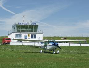
Rufzeichen / Call sign Biberach Info
Frequenz Tower 122.750 EN/GE
NAV Aids 313°/32 NM from KPT VOR/DME 109.60/Ch 33 146°/ 37 NM
from TGO VORTAC 112.50/Ch 72 - 233°/9 NM from LUP 407
Koordinaten 48 06, 66 N / 09 45, 77 E
Platzrunde / Traffic circuit NW 2700
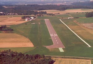
Landebahnen / RWY 1
RWY 980 x 23 m, ASPHALT
RWY 04 TKOF 980 m; LDG 780 m
RWY 22 TKOF 780 m; LDG 980 m
MTOW 5700 kg
Bemerkungen / Remarks GLD +PJE! Wohngebiete meiden!
Restaurant - Yes
Adresse Flugplatz
ZIP / City D-88477 Warthausen
Fon +49 (0)73519734
Fax 17860
E-mail: flugplatz at edmb de
WWW: http://www.edmb.de/
Images and information placed above are from
http://www.edmb.de/
http://www.airports.de/airport.php?ICAO=EDMB
We thank them for the data!
| General Info
|
| Country |
Germany
|
| ICAO ID |
EDMB
|
| Time |
UTC+1(+2DT)
|
| Latitude |
48.111000
48° 06' 39.60" N
|
| Longitude |
9.762833
009° 45' 46.20" E
|
| Elevation |
1903 feet
580 meters
|
| Magnetic Variation |
001° E (01/05)
|
| Beacon |
Yes
|
| Operating Agency |
CIVIL GOVERNMENT, (LANDING FEES AND DIPLOMATIC CLEARANCE MAY BE REQUIRED)
|
| Operating Hours |
SEE REMARKS FOR OPERATING HOURS OR COMMUNICATIONS FOR POSSIBLE HOURS
|
| Daylight Savings Time |
Last Sunday in March to last Sunday in October
|
| Communications
|
| INFO |
122.75
|
| MUNCHEN INFO |
126.95
|
| Runways
|
ID
|
Dimensions |
Surface |
PCN |
ILS
|
| 04/22 |
3215 x 75 feet
980 x 23 meters |
ASPHALT |
- |
NO
|
| Supplies/Equipment
|
| Fuel |
100/130 MIL Spec, low lead, aviation gasoline (BLUE)
|
| Remarks
|
| CAUTION |
Gldr cable winch launcher SE of ASP rwy.
|
| FUEL |
(NC-A1,100LL)
|
| LGT |
ABn flg W.
|
| OPR HOURS |
Opr 0800Z-SS+30 (0700-1800Z DT), O/T PPR.
|
Runway 04/22
3215 x 75 feet
980 x 23 meters
| Runway 04
|
| Surface |
ASPHALT
|
| True Heading |
041.0
|
| Latitude |
48.107053
48° 06' 25.39" N
|
| Longitude |
9.757742
009° 45' 27.87" E
|
| Landing Distance |
2559 feet
780 meters
|
| Takeoff Distance |
3215 feet
980 meters
|
| Displaced Threshold Length |
656 feet
200 meters
|
| Runway 22
|
| Surface |
ASPHALT
|
| True Heading |
221.0
|
| Latitude |
48.113722
48° 06' 49.40" N
|
| Longitude |
9.766344
009° 45' 58.84" E
|
| Landing Distance |
3215 feet
980 meters
|
| Takeoff Distance |
3215 feet
980 meters
|
The content above was published at Airports-Worldwide.com in 2005.
We don't guarantee the information is fresh and accurate. The data may be wrong or outdated.
For more up-to-date information please refer to other sources.
|


