 |
 |
|
||||
|
Kategorie Verkehrslandeplatz / Public Airfield Zoll / Customs O / R 2 hours SR-SS für Sport- und Privatflugzeuge,
sowie für in der Bundesrepublik beheimate Flugzeuge, die im gewerblichen
Gelegenheits-verkehr Personen befördern / for sporting and private
aircraft and for aircraft stationed in the Federal Republic and engaged
in non-scheduled commercial transport of passengers
WWW: http://www.airports.de/airport.php?ICAO=EDWR
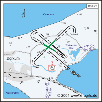
Images and information placed above are from http://www.airports.de/airport.php?ICAO=EDWR We thank them for the data!
Runway 05/232657 x 131 feet
|
||||||||||||||||||||||||||||||||||||||||||||||||||||||||||||||||||||||||||||||||||||||||||||||||||||||||||||||||||||||||||||||||||||||||||||||||||||||||||||||||||||||||||||||||||||||||||||||
| Runway 05 | |
|---|---|
| Surface | GRASS OR EARTH NOT GRADED OR ROLLED. |
| True Heading | 049.0 |
| Latitude | 53.592675 53° 35' 33.63" N |
| Longitude | 6.703792 006° 42' 13.65" E |
| Landing Distance | 2657 feet 810 meters |
| Takeoff Distance | 2657 feet 810 meters |
| Runway 23 | |
|---|---|
| Surface | GRASS OR EARTH NOT GRADED OR ROLLED. |
| True Heading | 229.0 |
| Latitude | 53.597492 53° 35' 50.97" N |
| Longitude | 6.712958 006° 42' 46.65" E |
| Landing Distance | 2657 feet 810 meters |
| Takeoff Distance | 2657 feet 810 meters |
| Runway 12 | |
|---|---|
| Surface | GRASS OR EARTH NOT GRADED OR ROLLED. |
| True Heading | 122.0 |
| Latitude | 53.595328 53° 35' 43.18" N |
| Longitude | 6.702186 006° 42' 07.87" E |
| Landing Distance | 2296 feet 700 meters |
| Takeoff Distance | 2854 feet 870 meters |
| Displaced Threshold Length | 558 feet 170 meters |
| Runway 30 | |
|---|---|
| Surface | GRASS OR EARTH NOT GRADED OR ROLLED. |
| True Heading | 302.0 |
| Latitude | 53.591239 53° 35' 28.46" N |
| Longitude | 6.713383 006° 42' 48.18" E |
| Landing Distance | 2854 feet 870 meters |
| Takeoff Distance | 2854 feet 870 meters |
| Runway 13 | |
|---|---|
| Surface | ASPHALT |
| True Heading | 132.0 |
| Latitude | 53.595083 53° 35' 42.30" N |
| Longitude | 6.709958 006° 42' 35.85" E |
| Landing Distance | 3281 feet 1000 meters |
| Takeoff Distance | 3281 feet 1000 meters |
| Lighting System | MIRL |
| Runway 31 | |
|---|---|
| Surface | ASPHALT |
| True Heading | 312.0 |
| Latitude | 53.589125 53° 35' 20.85" N |
| Longitude | 6.721261 006° 43' 16.54" E |
| Landing Distance | 3281 feet 1000 meters |
| Takeoff Distance | 3281 feet 1000 meters |
| Lighting System | MIRL |
The content above was published at Airports-Worldwide.com in 2005.
We don't guarantee the information is fresh and accurate. The data may be wrong or outdated.
For more up-to-date information please refer to other sources.

 |
|
Copyright 2004-2026 © by Airports-Worldwide.com, Vyshenskoho st. 36, Lviv 79010, Ukraine Legal Disclaimer |
 ICAO Code EDWR