 |
 |
|
||||
|
The passenger volume at Bremen Airport with a total of 1.639,834 passengers was 3.1 percent down from the previous year. 1.612,906 passengers flew to or from Bremen Airport (-3.0 percent), 26,928 were transit passengers (-11.6 percent). With a total of 1.004,261 travellers, scheduled traffic has seen a decline of five percent; the discontinuation of direct flight connections to Zurich, Vienna and partly also to London had a noticeable impact on this sector. Charter flight services with a total of about 598,000 passengers recorded a minor increase of 0.5 percent which could not, however, make up for the decline in scheduled traffic services. Miscellaneous non-scheduled traffic registered 10,393 passengers, 5.6 percent up from the previous year. The total volume of cargo amounted to 24,509 tonnes reaching a two-figure growth rate of 10.4 percent. Bremen Airport`s main focus is still on substitute truck traffic which transshipped 23,345 tonnes (+ 12.1 percent). Only 1,164 tonnes / 4.7 percent of the total volume was actually transported as air freight. The total annual tonnage of airmail transported - 1,075 tonnes - has
decreased by 78 percent compared to the previous year.The Deutsche Post
AG now transports mail by road and overnight mail flights were discontinued
at the beginning of the summer flight schedule. History: The origins of aviation in bremen date back to the year 1909 and it was just one year later that the first aircraft sheds appeared on the Neuenlander Feld. However, the airport s actual birthdate is the year 1913. For it was
in this year that the Bremen senate granted the Bremer Verein für
Luftfahrt (Bremen Aviation Association) official permission to operate
a flight base.
Kategorie Int. Verkehrsflughafen / Int. Airport Lage / Location 2 NM S Stadtmitte Bremen/Center of Bremen Zoll / Customs 0530-2200 (0430-2100), Passabfertigung/immigration 0530-2130
(0430-2030), OT PPR Address Flughafen Bremen GmbH PO box 28 61 52 Telephone numbers Airport Information: +49 (0) 421 5595-0 Press and Public Relations: +49 (0)421 5595-215 Marketing: +49 (0) 421 5595-444 Cargo: +49 (0) 421 5595-238 General Aviation Terminal:+49 (0) 421 5595-241 Fax numbers Generally: +49 (0) 421 5595-474 Order for flight plans and park coupons: Press and Public Relations: +49 (0) 421 5595-341 E-Mail - contact at airport-bremen de WWW: http://www.airport-bremen.de
Images and information placed above are from http://www.airport-bremen.de http://www.airports.de/airport.php?ICAO=EDDW We thank them for the data!
Runway 05/232297 x 75 feet
|
|||||||||||||||||||||||||||||||||||||||||||||||||||||||||||||||||||||||||||||||||||||||||||||||||||||||||||||||||||||||||||||||||||||||||||||||||||||||||||||||||||||||||||||||||||||||||||||||||||||||||||||||||||||||||||||||||||||||||||||||||||
| Runway 05 | |
|---|---|
| Surface | ASPHALT |
| True Heading | 052.0 |
| Latitude | 53.042567 53° 02' 33.24" N |
| Longitude | 8.784239 008° 47' 03.26" E |
| Landing Distance | 2297 feet 700 meters |
| Takeoff Distance | 2494 feet 760 meters |
| Overrun Length | 197 feet 60 meters |
| Overrun Surface | ASPHALT |
| Runway 23 | |
|---|---|
| Surface | ASPHALT |
| True Heading | 232.0 |
| Latitude | 53.046514 53° 02' 47.45" N |
| Longitude | 8.792400 008° 47' 32.64" E |
| Elevation | 13.0 feet 4 meters |
| Landing Distance | 2297 feet 700 meters |
| Takeoff Distance | 2297 feet 700 meters |
| Runway 09 | |
|---|---|
| Surface | ASPHALT |
| True Heading | 088.0 |
| Latitude | 53.046575 53° 02' 47.67" N |
| Longitude | 8.774453 008° 46' 28.03" E |
| Elevation | 13.0 feet 4 meters |
| Slope | 0.0° |
| Landing Distance | 6693 feet 2040 meters |
| Takeoff Distance | 7677 feet 2340 meters |
| Overrun Length | 984 feet 300 meters |
| Overrun Surface | ASPHALT |
| Lighting System | SF
TDZL CL HIRL REIL O PAPI |
| Runway 27 | |
|---|---|
| Surface | ASPHALT |
| True Heading | 268.0 |
| Latitude | 53.047264 53° 02' 50.15" N |
| Longitude | 8.804850 008° 48' 17.46" E |
| Elevation | 14.0 feet 4 meters |
| Slope | 0.0° |
| Landing Distance | 6693 feet 2040 meters |
| Takeoff Distance | 7677 feet 2340 meters |
| Overrun Length | 984 feet 300 meters |
| Overrun Surface | ASPHALT |
| Lighting System | SF
TDZL CL HIRL REIL O PAPI |
| BREMEN | |||||
|---|---|---|---|---|---|
| Type | ID | Channel | Freq | Country | State |
| VOR-DME | BMN | 121Y | 117.45 | Germany | - |
| Latitude | Longitude | Airport |
| 53.044050 53° 02' 38.58" N |
8.782139 008° 46' 55.70" E |
EDDW |
The content above was published at Airports-Worldwide.com in 2005.
We don't guarantee the information is fresh and accurate. The data may be wrong or outdated.
For more up-to-date information please refer to other sources.

 |
|
Copyright 2004-2026 © by Airports-Worldwide.com, Vyshenskoho st. 36, Lviv 79010, Ukraine Legal Disclaimer |
 Airport Traffic Statistics
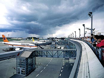 ICAO Code EDDW