|
 The airport Eisenach- Kindel is in the mid of Germany.
In the beginning of the nineties local politicians wanted to use the former
military airport for a different,
a civil purpose.
Now the airport Eisenach-Kindel as an airport - class 1 - is permitted
to be used by aeroplanes
and helicopters to 20 t MTOM. In the last years the number of flight movements
is constantly rising, which shows that
the airport is becoming more and more popular with pilots.
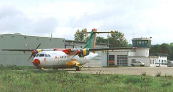
There is nothing left of old barracks and hangars. Rather the new terminal
with tower, snack-bar and flight halls, which
is architecturally on a high level, is a point of attraction for natives
and guests.
The airport with its dimensions of air traffic areas and the modern night
flight and lightening system has with no doubt a
good aerotechnical infrastructure.
The pilots and airlines profit of the better prices of the airport's free
petrol station.
Beyond that the airport Eisenach-Kindel offers airlines, aviation companies
and aerotechnical companies
good possibilities to settle directly on the airport areas on a surface
of 5 hectares.
With no doubt the good developed infrastructure of the region is important
for the settlement decision.
ICAO Code EDGE
Name EISENACH - Kindel
Land Deutschland
Bundesland Thüringen
Letzte Änderung 14. Oktober 2004
Kategorie Verkehrslandeplatz / Public Airfield
Betreiber / Operator Flugplatzgesellschaft Eisenach-Kindel mbH
Lage / Location 5.4 NM E Eisenach
LFZ / ACFT Bis / up to 5700 kg, 20000 kg PPR, HEL 20000 kg, >20000
kg PPR
Helicopter Ja / Yes
Motorsegler / GLDP Ja / Yes
UL Ja / Yes
Summer MON-FRI 0600-1800, SAT, SUN, HOL 0700-1800
Winter MON-FRI 0700-SS+30, SAT,SUN, HOL 0800-SS+30
O/T PPR
Luftaufsicht / OPS +49 (0)36920 / 80890
AIS AIS-Centre EDDZ, +49 (0)69 / 78072500
MET (0190) 077226
Gafor 24
Zoll / Customs PPR 24 H vorher/before DEP/ARR
Zoll / Customs Fon +49 (0)361 / 392283
Fuel 100 LL, Jet A1
Oil Nein / No
Hangar O / R
Höhe / Elevation 1101 ft / 339 m
FIS Berlin Information 125.800
VDF / QDM 119.750
Rufzeichen / Call sign Eisenach Info
Frequenz Tower 119.750 GE
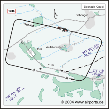
NAV Aids 244°/47 NM from GOT VOR/DME 115.25/Ch 99y - 055°/42 NM
from FUL 112.10 - 271°/15 NM from ERT 452
Koordinaten 50 59, 53 N / 10 28, 56 E
Platzrunde / Traffic circuit N 1900
Landebahnen / RWY 1
RWY 1720 x 55 m, CONCRETE
RWY 10 TKOF 1500 m; LDG 1720 m
RWY 28 TKOF 1720 m; LDG 1500 m
MTOW 5700 kg, PPR 20000 kg
Bemerkungen / Remarks ED-R 90 (GND/3300 MSL, Wartburg) beachten! Wohngebiete
meiden! UL-Betrieb!
Restaurant - Yes
Adresse
Adresse Am Flugplatz
ZIP / City D-99819 Hörselberg
Verwaltung
Tel./Fax: 0 369 20 / 80 89-2
Flugleitung
Tel.: 0 369 20 / 80 89-0
Fax: 0 369 20 / 80 98-5
e-Mail: info at flugplatz-eisenach de
WWW:
http://www.flugplatz-eisenach.de/
Images and information placed above are from
http://www.airports.de/airport.php?ICAO=EDGE
We thank them for the data!
| General Info
|
| Country |
Germany
|
| ICAO ID |
EDGE
|
| Time |
UTC+1(+2DT)
|
| Latitude |
50.992797
50° 59' 34.07" N
|
| Longitude |
10.472711
010° 28' 21.76" E
|
| Elevation |
1101 feet
336 meters
|
| Magnetic Variation |
001° E (01/05)
|
| Beacon |
Yes
|
| Operating Agency |
CIVIL GOVERNMENT, (LANDING FEES AND DIPLOMATIC CLEARANCE MAY BE REQUIRED)
|
| Alternate Name |
HAINA
|
| Operating Hours |
SEE REMARKS FOR OPERATING HOURS OR COMMUNICATIONS FOR POSSIBLE HOURS
|
| Daylight Savings Time |
Last Sunday in March to last Sunday in October
|
| Communications
|
| INFO |
119.75
|
| BERLIN INFO |
125.8
|
| Runways
|
ID
|
Dimensions |
Surface |
PCN |
ILS
|
| 10/28 |
5643 x 180 feet
1720 x 55 meters |
CONCRETE. |
- |
NO
|
| Supplies/Equipment
|
| Fuel |
Jet A1, without icing nhibitor.
100/130 MIL Spec, low lead, aviation gasoline (BLUE)
|
| Remarks
|
| CSTMS/AG/IMG |
Opr 24 hr PPR.
|
| FUEL |
(NC-100LL, A1)
|
| MISC |
Gldr act.
|
| OPR HOURS |
Opr 0700Z-SS+30 Mon-Fri; 0800Z-SS+30 Sat, Sun and hol; O/T PPR (0600-1800Z Mon-Fri; 0700-1800Z Sat, Sun and hol; O/T PPR DT).
|
Runway 10/28
5643 x 180 feet
1720 x 55 meters
| Runway 10
|
| Surface |
CONCRETE.
|
| True Heading |
105.0
|
| Latitude |
50.994167
50° 59' 39.00" N
|
| Longitude |
10.464444
010° 27' 52.00" E
|
| Landing Distance |
5643 feet
1720 meters
|
| Takeoff Distance |
5643 feet
1720 meters
|
| Lighting System |
LIRL
PAPI
LIGHTS |
| Runway 28
|
| Surface |
CONCRETE.
|
| True Heading |
285.0
|
| Latitude |
50.990236
50° 59' 24.85" N
|
| Longitude |
10.488139
010° 29' 17.30" E
|
| Landing Distance |
4921 feet
1500 meters
|
| Takeoff Distance |
5643 feet
1720 meters
|
| Displaced Threshold Length |
722 feet
220 meters
|
| Lighting System |
LIRL
PAPI
LIGHTS |
The content above was published at Airports-Worldwide.com in 2005.
We don't guarantee the information is fresh and accurate. The data may be wrong or outdated.
For more up-to-date information please refer to other sources.
|


