 |
|
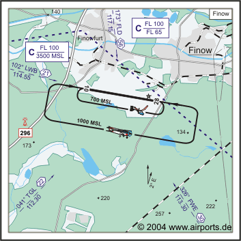
ICAO Code EDAV
Name FINOW
Land Deutschland
Bundesland Brandenburg
Letzte Änderung 9. März 2003
Kategorie Verkehrslandeplatz / Public Airfield
Betreiber / Operator Tower Finnow GmbH
Lage / Location 1 NM SW Eberswalde
Nachtflug / NVFR NVFR
LFZ / ACFT Bis / up to 14000 kg
Helicopter Ja / Yes
Motorsegler / GLDP Ja / Yes
Ballone Ja / Yes
UL Ja / Yes
Luftschiffe/airships PPR
Summer MON-FRI 0600-SS+30/1800, SS+30-2000 O/R 2HR, SR-30-0700 OR 2HR,
Sat, Sun, HOL 0700-SS+30/1800, SS+30-2000 O/R 2 HR, SR-30-0700 O/R 2 HR
Winter MON-FRI 0800-SS+30, SS+30-2100 O/R 2 HR, SR-30-0700 O/R 2HR
O/T PPR
Luftaufsicht / OPS +49 (0)3334 / 34418, Fax 34418
PPR +49 (0)3334 / 34418, 350610, 0171/6121149
AIS EDDB +49 (0)30 / 60918250
MET (0190) 077222
Gafor 18
Zoll / Customs O/R 4 HR
Zoll / Customs Fon +49 (0)3334 / 34418, 350610
Fuel 100 LL, Jet A1
Oil Aero Shell Oil 80/100, W 80, W 100, AW 15/50
Hangar Ja / Yes
Höhe / Elevation 121 ft / 37 m
FIS Berlin Information 126.350
Rufzeichen / Call sign Finnow Info
Frequenz Tower 119.050 EN / GE
NAV Aids 042°/22 NM from TGL DVOR/DME 112.30/Ch 70 327°/30 NM
from FWE VOR/DME 113.30/Ch 80 103°/21 NM from LWB VOR/DME 114.55/Ch
105y 174°/56 NM from FLD 117.15
Koordinaten 52 49, 63 N / 13 41, 61 E
Platzrunde / Traffic circuit S 1000
Landebahnen / RWY 1
RWY 2520 x 50 m, CONCRETE
RWY 10 TKOF 2520 m; LDG 2520 m
RWY 28 TKOF 2520 m; LDG 2520 m
MTOW PCN 58R/B/W/U
Bemerkungen / Remarks Airspace C Berlin (3500 MSL/FL 100) Frequenz: 121.050!
UL acft PPR! Wohngebiete meiden!
Restaurant - Yes
Adresse
Am Flugplatz 1
ZIP / City D-16227 Eberswalde
Fon +49 (0)3334 / 350610
Fax 34418
WWW: http://www.airports.de/airport.php?ICAO=EDAV
Images and information placed
above are from
http://www.airports.de/airport.php?ICAO=EDAV
We thank them for the data!
| General Info
|
| Country |
Germany
|
| ICAO ID |
EDAV
|
| Time |
UTC+1(+2DT)
|
| Latitude |
52.827167
52° 49' 37.80" N
|
| Longitude |
13.693500
013° 41' 36.60" E
|
| Elevation |
121 feet
37 meters
|
| Type |
Civil
|
| Magnetic Variation |
002° E (01/05)
|
| Beacon |
Yes
|
| Operating Agency |
CIVIL GOVERNMENT, (LANDING FEES AND DIPLOMATIC CLEARANCE MAY BE REQUIRED)
|
| Operating Hours |
SEE REMARKS FOR OPERATING HOURS OR COMMUNICATIONS FOR POSSIBLE HOURS
|
| Daylight Savings Time |
Last Sunday in March to last Sunday in October
|
| Communications
|
| INFO |
119.05
|
| BERLIN INFO |
126.35
280.9
|
| Runways
|
ID
|
Dimensions |
Surface |
PCN |
ILS
|
| 10/28 |
8268 x 164 feet
2520 x 50 meters |
CONCRETE. |
058RBWU |
NO
|
| Supplies/Equipment
|
| Fuel |
Unknown fuel type or whether there is any fuel.
|
| Remarks
|
| CAUTION |
Gldr act.
|
| CSTMS/IMG |
CSTMS avbl O/R 4 hr, C03334-34418.
|
| FUEL |
(NC 100LL, A1)
|
| OPR HOURS |
Opr 0800Z-SS+30 Mon-Fri, OT PPR 2 hr before SR and 2 hr aft SS, OT PPR , (0600Z-SS+30/1800 Mon-Fri, OT PPR 2 hr before SR and 2 hr aft SS, OT PPR DT).
|
Runway 10/28
8268 x 164 feet
2520 x 50 meters
| Runway 10
|
| Surface |
CONCRETE.
|
| True Heading |
100.0
|
| Latitude |
52.829119
52° 49' 44.83" N
|
| Longitude |
13.675086
013° 40' 30.31" E
|
| Elevation |
112.0 feet
34 meters
|
| Slope |
0.1°
|
| Landing Distance |
8268 feet
2520 meters
|
| Takeoff Distance |
8268 feet
2520 meters
|
| Lighting System |
MIRL
|
| Runway 28
|
| Surface |
CONCRETE.
|
| True Heading |
280.0
|
| Latitude |
52.825211
52° 49' 30.76" N
|
| Longitude |
13.711911
013° 42' 42.88" E
|
| Elevation |
121.0 feet
37 meters
|
| Slope |
-0.1°
|
| Landing Distance |
8268 feet
2520 meters
|
| Takeoff Distance |
8268 feet
2520 meters
|
| Lighting System |
SF
MIRL
REIL
A4
PAPI |
The content above was published at Airports-Worldwide.com in 2005.
We don't guarantee the information is fresh and accurate. The data may be wrong or outdated.
For more up-to-date information please refer to other sources.
|
|


