 |
|
|
|
 |
|
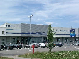 Frankfurt-Hahn Airport - 'Gateway to the world'
Since its inception as a civil airport in 1993, Frankfurt-Hahn has become
one of Germany’s fastest growing airports. A US military base from
the 50’s to start of the 90's, this is the first German low cost
airport to attain a 24-hour operating licence. Within only ten years,
Frankfurt-Hahn Airport has become the tenth-largest international airport
in Germany. In the freight sector, the all-important second leg of a successful
airport, Frankfurt-Hahn is in 4th place in Germany and 96th place world-wide.
The Frankfurt Hahn Airport is a veritable melting pot of travellers from
the whole world. This international gateway to the Rhineland-Palatinate
region boasts around 54 passenger flights within Europe a day, including
the low-cost airline Ryanair. In our first year of commercial operation,
we had a mere 7,000 passengers - today we have about 8,000 per day! Cut
price destinations include such places as France, Italy, Spain and Scandinavia.
In the holiday season, large tour operators such as Berge&Meer and
FlyCar organise charter flights to popular summer and holiday areas e.g.
in Turkey or Swedish Lappland.
 In April 1999, the Irish low cost airline Ryanair settled on Frankfurt-Hahn
as a destination. Since then Frankfurt-Hahn is considered as the prototype
for many regional airports around Germany as well as the rest of Europe.
Passenger numbers are rapidly on the rise – in 2002 the number of
airline passengers exceeded the million mark for the first time and in
2003 the two million mark was broken. In addition to this, the number
of the company contracts as well as jobs is increasing just as fast. In
1996, there were around 30 companies registered with us, whereas today
there are over 105 companies contracts encompassing all commercial sectors.
Equally, the number of jobs rose from 53 in 1996 to just above 2300 today.
In April 1999, the Irish low cost airline Ryanair settled on Frankfurt-Hahn
as a destination. Since then Frankfurt-Hahn is considered as the prototype
for many regional airports around Germany as well as the rest of Europe.
Passenger numbers are rapidly on the rise – in 2002 the number of
airline passengers exceeded the million mark for the first time and in
2003 the two million mark was broken. In addition to this, the number
of the company contracts as well as jobs is increasing just as fast. In
1996, there were around 30 companies registered with us, whereas today
there are over 105 companies contracts encompassing all commercial sectors.
Equally, the number of jobs rose from 53 in 1996 to just above 2300 today.
Frankfurt-Hahn is thus one of Germany’s most powerful catalysts
for growth in the areas of business, service and employment.
ICAO Code EDFH
IATA Code HHN
Name FRANKFURT-Hahn
Land Deutschland
Bundesland Rheinland-Pfalz
Letzte Änderung 31. März 2005
Kategorie Verkehrsflughafen / Airport
Betreiber / Operator Flughafen Frankfurt-Hahn GmbH
Lage / Location 5.5 NM W Kirchberg(Hunsrück)
Nachtflug / NVFR NVFR
Instrumentenflug / IFR IFR
LFZ / ACFT Bis / up to PCN 40/ACN 40
Helicopter Ja / Yes
Motorsegler / GLDP Ja / Yes
andere Luftfahrzeuge/other aircraft PPR
Summer H 24, CTR H 24
Winter H 24, CTR H 24
Einschränkungen siehe AIP VFR (Kartenteil) - Restriction see AIP
VFR (chart section)
Luftaufsicht / OPS +49 (0)6543 / 509141, Fax 509142
PPR FHG +49 (0)6543 / 509236, Fax 509214, SITA HHNAPXH, HHNKOXH, HHNKLXH
AIS AIS-Centre EDDZ, +49 (0)69 / 78072500
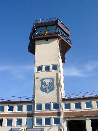
Tower Turm +49 (0)6543 / 4417, Fax 509150
MET (0190) 077224
Gafor 41
Zoll / Customs Zoll/Customs H24, Grenzabfertigung/Immigration 0530-0030,
O/T PPR
Fuel 100 LL, Jet A1
Oil 80, 100, D80, D 100, 15 W 50, AW 15 W 50, Turbo-Jet Oil PPR
Hangar Ja / Yes
Höhe / Elevation 1649 ft / 503 m
FIS Langen Information 123.325, Hahn ATIS 136.350
VDF / QDM 119.650
Rufzeichen / Call sign Hahn Tower/Turm
Frequenz Tower 119.650 EN/GE
Frequenz Ground 121975
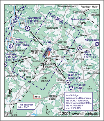
NAV Aids ABN PAPI DME HND 116.95 am Platz/at field 325°/7 NM from
KIR 117.50 ILS RWY 03 109.30 ILS RWY 21 111.30
Koordinaten 49 56, 92 N / 07 15, 83 E
Landebahnen / RWY 1
RWY 3045 x 45 m, BITUMEN
RWY 03 TKOF 3045 m; LDG 2745 m
RWY 21 TKOF 3045 m; LDG 2745 m
MTOW 72 F/C/X/T
Restaurant Ja/yes
Adresse
Gebäude 667
ZIP / City D-55483 Hahn Flughafen
Fon +49 (0)6543 / 509200
Fax 509202
E-Mail: info at hahn-airport de
WWW: Frankfurt-Hahn Airport
Images and information placed
above are from
http://www.airports.de/airport.php?ICAO=EDFH
We thank them for the data!
| General Info
|
| Country |
Germany
|
| ICAO ID |
EDFH
|
| Time |
UTC+1(+2DT)
|
| Latitude |
49.948672
49° 56' 55.22" N
|
| Longitude |
7.263892
007° 15' 50.01" E
|
| Elevation |
1649 feet
503 meters
|
| Type |
Civil
|
| Magnetic Variation |
000° E (01/05)
|
| Beacon |
Yes
|
| Operating Agency |
CIVIL GOVERNMENT, (LANDING FEES AND DIPLOMATIC CLEARANCE MAY BE REQUIRED)
|
| Near City |
Hahn
|
| Operating Hours |
SEE REMARKS FOR OPERATING HOURS OR COMMUNICATIONS FOR POSSIBLE HOURS
|
| Daylight Savings Time |
Last Sunday in March to last Sunday in October
|
| Communications
|
| TWR |
119.65
337.45
(Emerg altn freq 120.9)
|
| GND |
121.975
|
| ATIS |
136.35
|
| LANGEN RADAR |
125.6
340.125
|
| LANGEN INFO |
123.525
|
| Runways
|
ID
|
Dimensions |
Surface |
PCN |
ILS
|
| 03/21 |
9990 x 148 feet
3045 x 45 meters |
ASPHALT |
072FCXT |
YES
|
| Navaids
|
| Type |
ID |
Name |
Channel |
Freq |
Distance From Field |
Bearing From Navaid
|
| NDB |
HAN |
HAHN |
- |
376 |
1.2 NM |
214.0
|
| DME |
HND |
HAHN |
116Y |
- |
At Field |
-
|
| Supplies/Equipment
|
| Fuel |
Jet A1, without icing nhibitor.
100/130 MIL Spec, low lead, aviation gasoline (BLUE)
|
| Remarks
|
| CSTMS/IMG |
CSTMS H24, IMG avbl dly 0530-0030Z++, O/T PPR.
|
| FLUID |
De-Ice avbl.
|
| FUEL |
(NC-100LL, A1)
|
| LGT |
PAPI Rwy 03 MEHT 49', Rwy 21 MEHT 52'.
|
| NS ABTMT |
In eff 2100-0500Z++.
|
| RSTD |
Twy D unuse for acft exceeding 30,864 lbs.
|
| RWY |
TODA Rwy 03 10,187', Rwy 21 10,810'.
|
Runway 03/21
9990 x 148 feet
3045 x 45 meters
| Runway 03
|
| Surface |
ASPHALT
|
| True Heading |
032.0
|
| Latitude |
49.937122
49° 56' 13.64" N
|
| Longitude |
7.252503
007° 15' 09.01" E
|
| Elevation |
1643.0 feet
501 meters
|
| Slope |
-0.6°
|
| Landing Distance |
9006 feet
2745 meters
|
| Takeoff Distance |
9990 feet
3045 meters
|
| Displaced Threshold Length |
984 feet
300 meters
|
| Lighting System |
SF
CL
HIRL
REIL
A1
PAPI |
| Runway 21
|
| Surface |
ASPHALT
|
| True Heading |
212.0
|
| Latitude |
49.960222
49° 57' 36.80" N
|
| Longitude |
7.275286
007° 16' 31.03" E
|
| Elevation |
1586.0 feet
483 meters
|
| Slope |
0.6°
|
| Landing Distance |
9006 feet
2745 meters
|
| Takeoff Distance |
9990 feet
3045 meters
|
| Displaced Threshold Length |
984 feet
300 meters
|
| Lighting System |
SF
TDZL
CL
HIRL
REIL
A1
PAPI |
Navaids
| HAHN
|
| Type |
ID |
Channel |
Freq |
Country |
State
|
| NDB |
HAN |
- |
376 |
Germany |
-
|
| Latitude |
Longitude |
Airport
|
49.964883
49° 57' 53.58" N |
7.280875
007° 16' 51.15" E |
EDFH |
Navaids
| HAHN
|
| Type |
ID |
Channel |
Freq |
Country |
State
|
| DME |
HND |
116Y |
- |
Germany |
-
|
| Latitude |
Longitude |
Airport
|
49.945569
49° 56' 44.05" N |
7.267669
007° 16' 03.61" E |
EDFH |
The content above was published at Airports-Worldwide.com in 2005.
We don't guarantee the information is fresh and accurate. The data may be wrong or outdated.
For more up-to-date information please refer to other sources.
|
|


