 |
|
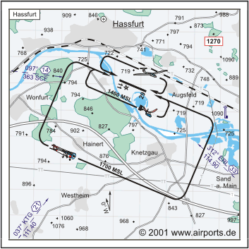
Hassfurt-Schweinfurt Airfield |
ICAO Code EDQT
Name HASSFURT - Schweinfurt
Land Deutschland
Bundesland Bayern
Letzte Änderung 11. Mai 2005
Kategorie Verkehrslandeplatz / Public Airfield
Betreiber / Operator Verkehrslandeplatz Haßfurt-Schweinfurt GmbH
Lage / Location 0.8 NM SE Haßfurt
Nachtflug / NVFR NVFR
LFZ / ACFT Bis / up to 5700 kg, HEL 5700 kg
Helicopter Ja / Yes
Motorsegler / GLDP Ja / Yes
Segelflugzeuge / GLD Ja / Yes
UL Ja / Yes
Fallschirmspringen / PJE Ja / Yes
Summer TUE - SUN 0800-SS/1800
Winter TUE - SUN 0900-SS
O/T PPR
Einschränkungen siehe AD 1-6 / Restrictions see AD 1-6
Luftaufsicht / OPS +49 (0)9521 / 94990, Fax 949920
PPR +49 (0)9521 / 94990, 1848, 0175 / 6630260, 0172 / 6715334, 0172 /
2335418
AIS AIS-Centre EDDZ, +49 (0)69 / 78072500
APP EDDN +49 (0)89 / 9780330
MET (0190) 077224
Gafor 54
Zoll / Customs nein/no
Fuel 100 LL, Jet A1, Super Plus
Oil D 80, D 100
Hangar Ja / Yes
Höhe / Elevation 718 ft / 219 m
FIS Langen Information 127.975
Rufzeichen / Call sign Hassfurt Info
Frequenz Tower 119.800 EN/GE
NAV Aids ABN PAPI 097°/14 NM from SCF NDB 363 037°/21 NM from
KTG VOR/DME 114.90/Ch 96 312°/33 NM from ERL 114.90
Koordinaten 50 01, 08 N / 10 31, 77 E
Platzrunde / Traffic circuit SW 1700
Landebahnen / RWY 1
RWY 1100 x 20 m, ASPHALT
RWY 11 TKOF 1200 m; LDG 1200 m
RWY 29 TKOF 1200 m; LDG 1200 m
MTOW 5700 kg
Bemerkungen / Remarks Haßfurt nicht überfliegen! GLD + PJE!
UL acft PPR!
Restaurant - yes
Adresse
Flugplatzstr. 20
ZIP / City D-97437 Haßfurt
WWW: Hassfurt-Schweinfurt
Airfield
Images and information placed
above are from
http://www.airports.de/airport.php?ICAO=EDQT
We thank them for the data!
| General Info
|
| Country |
Germany
|
| ICAO ID |
EDQT
|
| Time |
UTC+1(+2DT)
|
| Latitude |
50.018000
50° 01' 04.80" N
|
| Longitude |
10.529500
010° 31' 46.20" E
|
| Elevation |
718 feet
219 meters
|
| Magnetic Variation |
001° E (01/05)
|
| Beacon |
Yes
|
| Operating Agency |
CIVIL GOVERNMENT, (LANDING FEES AND DIPLOMATIC CLEARANCE MAY BE REQUIRED)
|
| Operating Hours |
SEE REMARKS FOR OPERATING HOURS OR COMMUNICATIONS FOR POSSIBLE HOURS
|
| Daylight Savings Time |
Last Sunday in March to last Sunday in October
|
| Communications
|
| INFO |
119.8
|
| LANGEN INFO |
127.975
|
| Runways
|
ID
|
Dimensions |
Surface |
PCN |
ILS
|
| 11/29 |
3609 x 66 feet
1100 x 20 meters |
ASPHALT |
- |
NO
|
| Supplies/Equipment
|
| Fuel |
Jet A1, without icing nhibitor.
100/130 MIL Spec, low lead, aviation gasoline (BLUE)
|
| Remarks
|
| CAUTION |
Glider winch launching, PJE.
|
| CSTMS/IMG |
Avbl O/R 2 hr 1000-1800Z++.
|
| FUEL |
(NC-100LL, A1)
|
| LGT |
PAPI both rwy GS 3.5 .
|
| MISC |
Ovrns can be used for tkof.
|
| OPR HOURS |
Opr 0900Z++-SS Tue-Sun, OT PPR 2 hr. Fone C(09521) 94990, 1848.
|
| RSTD |
Ctc INFO 5 min prior to afld. Do not overfly town of Hassfurt.
|
Runway 11/29
3609 x 66 feet
1100 x 20 meters
| Runway 11
|
| Surface |
ASPHALT
|
| True Heading |
113.0
|
| Latitude |
50.020039
50° 01' 12.14" N
|
| Longitude |
10.522394
010° 31' 20.62" E
|
| Landing Distance |
3609 feet
1100 meters
|
| Takeoff Distance |
3937 feet
1200 meters
|
| Overrun Length |
328 feet
100 meters
|
| Overrun Surface |
ASPHALT
|
| Lighting System |
LIRL
PAPI |
| Runway 29
|
| Surface |
ASPHALT
|
| True Heading |
293.0
|
| Latitude |
50.016064
50° 00' 57.83" N
|
| Longitude |
10.536497
010° 32' 11.39" E
|
| Landing Distance |
3609 feet
1100 meters
|
| Takeoff Distance |
3937 feet
1200 meters
|
| Overrun Length |
328 feet
100 meters
|
| Overrun Surface |
ASPHALT
|
| Lighting System |
LIRL
PAPI |
The content above was published at Airports-Worldwide.com in 2005.
We don't guarantee the information is fresh and accurate. The data may be wrong or outdated.
For more up-to-date information please refer to other sources.
|
|


