 |
 |
|
||||
|
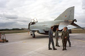
East German Airforce fighter base until 1990. Now - GAF (Bundeswehr Luftwaffe).
Images and information placed above are from http://www.alexfunke.com/ We thank them for the data!
Runway 09/277936 x 98 feet
|
||||||||||||||||||||||||||||||||||||||||||||||||||||||||||||||||||||||||||||||||||||||||||||||||||||||||||||||||||||||||||||||||||||||||||||||||||||||||||||||||||||||||||||||||||||||||||||||||||||||||||||||||||||||||||||||||||||||||||
| Runway 09 | |
|---|---|
| Surface | PART CONCRETE, PART ASPHALT, OR PART BITUMEN-BOUND MACADAM. |
| True Heading | 094.0 |
| Latitude | 51.768500 51° 46' 06.60" N |
| Longitude | 13.150167 013° 09' 00.60" E |
| Elevation | 254.0 feet 77 meters |
| Slope | 0.1° |
| Landing Distance | 7936 feet 2419 meters |
| Takeoff Distance | 8887 feet 2709 meters |
| Overrun Length | 951 feet 290 meters |
| Overrun Surface | CONCRETE. |
| Lighting System | SF
HIRL BP PAPI |
| Runway 27 | |
|---|---|
| Surface | PART CONCRETE, PART ASPHALT, OR PART BITUMEN-BOUND MACADAM. |
| True Heading | 274.0 |
| Latitude | 51.767167 51° 46' 01.80" N |
| Longitude | 13.185167 013° 11' 06.60" E |
| Elevation | 263.0 feet 80 meters |
| Slope | -0.1° |
| Landing Distance | 7936 feet 2419 meters |
| Takeoff Distance | 8887 feet 2709 meters |
| Overrun Length | 951 feet 290 meters |
| Overrun Surface | CONCRETE. |
| Lighting System | SF
HIRL BP PAPI |
| HOLZDORF | |||||
|---|---|---|---|---|---|
| Type | ID | Channel | Freq | Country | State |
| TACAN | HOZ | 119Y | - | Germany | - |
| Latitude | Longitude | Airport |
| 51.766667 51° 46' 00.00" N |
13.199000 013° 11' 56.40" E |
ETSH |
| HOLZDORF | |||||
|---|---|---|---|---|---|
| Type | ID | Channel | Freq | Country | State |
| NDB | HOZ | - | 406 | Germany | - |
| Latitude | Longitude | Airport |
| 51.769833 51° 46' 11.40" N |
13.097500 013° 05' 51.00" E |
ETSH |
The content above was published at Airports-Worldwide.com in 2005.
We don't guarantee the information is fresh and accurate. The data may be wrong or outdated.
For more up-to-date information please refer to other sources.

 |
|
Copyright 2004-2026 © by Airports-Worldwide.com, Vyshenskoho st. 36, Lviv 79010, Ukraine Legal Disclaimer |
 Opened early 1980s.