 |
|
Lahr (Black Forest) Airport |
 Lahr
lies in the Rhine Valley beneath the Black Forest close to the university
city of Freiburg and Strasbourg- home of the European Parliament. Lahr
lies in the Rhine Valley beneath the Black Forest close to the university
city of Freiburg and Strasbourg- home of the European Parliament.
Its central location on one of the most important transport axes (A5)
and its proximity to France and Switzerland are among other advantages
enjoyed by Lahr with its population of 45,000 EUROPA-PARK, Germany’s
largest open air leisure park with 3,6 million visitors annually and the
largest hotel in Germany lie practically on the doorstep.
The extensive area of the ex-NATO airbase lies right by the motorway
junction offering room for development opportunities as well as storage
space and existing buildings for rental on the industry and business park.
The southern Upper Rhine region is home to many well-known globally active
companies Including Herrenknecht AG, Duravit AG, Grohe Water Technology
AG, Hubert Burda Media, Janoschka Group and VIVIL
HISTORY:
 1913
Opening as an airfield for Zeppelin 1913
Opening as an airfield for Zeppelin
1928 Designated as International Zeppelin airfield. Later used as military
airfield.
1945 French Military occupation of Lahr.
1946 Lahr becomes base for 1. Airforce Division, 1. CATAC (Commandement
Aérien Tactique). Headquarters for the Commandement General of
the French Airforce in Germany.
1952 Base for NATO Fighter aircrafts.
1967 France leaves NATO. French troops withdrawn. Replaced by Canadian
Starfighter Squadron formally based at MArville, France. Headquarters
and Garrison town for the Canadian NATO troops.
1970 Canadian 4th. Mechanised Brigade stationed in Lahr. Logistic support
for Canadian troops in Europe
1990 Political and governmental changes in Eastern Europe.
1993 Plans developed for civil use of airbase.
1994 Canadian troops withdrawn
1995 Last of Canadian Forces leave. Conversion and civil use of military
property begins.
1996 Founding of the airfield company: Flugplatz Lahr GmbH
1997 Development of Industrial and Business park by the city of Lahr and
Friesenheim Region. Permission given for development of industrial areas
Raum Lahr 1 (West) Rheinstrasse Nord (Ost).
1998 Viability of the areas and first companies established.
1999 Lahr bids for the production and manufacture of the Airbus A380.
2000 Strasbourg Airport closed for renovations for 40 days. Lahr Airport
served as an alternate landing strip for 1/3 of Strasbourg Airport air
traffic, with 25 000 passengers passing through.
2001 The British company, Wiggins Group plc. becomes majority shareholder
of the Flugplatz Lahr GmbH.
Establishment of the Black Forest Airport Lahr GmbH.
2002 Application for General Airport Licence in December
2002 Black Forest Airport Lahr achieves the status of „Special Cargo
Airport“
2004 Decision of the Regierungspräsidium as licensing authority NOT
to allow BFAL to be a General Civil Airport
2004 Black Forest Airport Lahr GmbH supported by PlaneStation Group plc
as parent
company submits action against the decision of the licensing authority.
2005 28.February:The Higher Administrative Court Baden-Württemberg
held today, that the refusal by the Regierungspräsidium Freiburg
of the petition to grant a general airport licence for Lahr was illegal
and is revoked. Moreover, the Court held that the Regierungspräsidium
Freiburg is obligated to decide again Black Forest Airport Lahr Gmbh´s
petition based on the Court´s opinion as laid out in the written
judgement ( Case No.8 S 2004/04 )
2005 29.April: An administrative appeal has been given to the Federal
Admistrative Court in Leipzig by the Gouvernement of Baden-Württemberg
because the Higher Admistrative Court Baden-Württemberg excluded
an appeal against their decision.
 ICAO Code EDTL
IATA Code LHA
Name LAHR
Land Deutschland
Bundesland Baden-Württemberg
Letzte Änderung 31. März 2005
Kategorie Verkehrslandeplatz / Public Airfield
Betreiber / Operator Black Forest Airport Lahr GmbH
Lage / Location 1.9 NM N Lahr
Nachtflug / NVFR NVFR
Instrumentenflug / IFR IFR
LFZ / ACFT Bis / up to 14000 kg, 20000 kg PPR, HEL 14000 kg, 20000 PPR
Helicopter Ja / Yes
Motorsegler / GLDP Ja / Yes
Segelflugzeuge / GLD Ja / Yes
UL Ja / Yes
Piloten von Luftsportgeräten benötigen MNM BZF II / UL pilots
require a licence for radiotelephony MNM BZF II
Summer Mon - Fri 0600-1800, PPR 0400-0600, 1800-2200Sat, Sun, HOL 0700-1600,
PPR 0400-0700, 1600-2200
Winter Mon - Fri 0700-1900, PPR 0500-0700, 1900-2300, Sat, Sun, HOL 0800-1700,
PPR 0500-0800, 1700-2300
O/T PPR
Einschränkungen siehe AD 1-6 / Restrictions see AD 1-6
Luftaufsicht / OPS +49 (0)7821 / 994200, Fax 994253
AIS AIS-Centre EDDZ, +49 (0)69 / 78072500
ACC EDDF +49 (0)6103 / 7076200
APP LFST +33 388596313
MET (0190) 077227
Gafor 61
Zoll / Customs Während der Betriebszeiten/During operating hours:
O / R 1HR Nur für nichtgewerblichen Verkehr und gewerblichen Gelegenheitsverkehr
ohne Handelsware./ For non-commercial traffic without merchandise only.
Fuel 100 LL, Jet A1
Oil EE, EE 20-50
Hangar Beschränkt / Limited
Höhe / Elevation 511 ft / 155 m
FIS Langen Information 128.950
VDF / QDM 125.175 121.500
Rufzeichen / Call sign Lahr Info
Frequenz Tower 125.175 EN/GE
NAV Aids ABN PAPI DME LRD Ch 17y/108.05 am Platz /at field 030°/0.5
NM from LHR NDB 337 130°/13 NM from STR VORTAC 115.60/Ch 103 270°/33
NM from SUL VOR 116.10
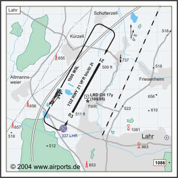
Koordinaten 48 22, 15 N / 07 49, 67 E
Platzrunde / Traffic circuit NE 1500
Landebahnen / RWY 1
RWY 3000 x 45 m, CONC/ASPHALT
RWY 03 TKOF 3000 m; LDG 3000 m
RWY 21 TKOF 3000 m; LDG 3000 m
MTOW PCN 100/F/D/W/T
Bemerkungen / Remarks Luftraum F (HX) GLD! UL-Betrieb! Wohngebiete meiden!
Restaurant Ja
Adresse
Europastr. 1 Geb A20
ZIP / City D-77933
Lahr
Fon +49 (0)7821 /9940
Fax 994110
URL http://www.blackforest-airport.com/
eMail info at blackforest-airport com
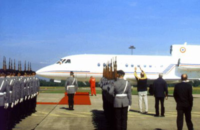
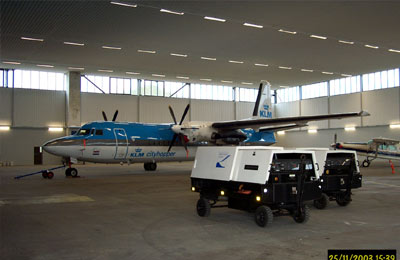
Images and information placed above are from http://www.airports.de/airport.php?ICAO=EDTL
http://www.blackforest-airport.com/
We thank them for the data!
| General Info
|
| Country |
Germany
|
| ICAO ID |
EDTL
|
| Time |
UTC+1(+2DT)
|
| Latitude |
48.369250
48° 22' 09.30" N
|
| Longitude |
7.827722
007° 49' 39.80" E
|
| Elevation |
511 feet
156 meters
|
| Magnetic Variation |
000° E (01/05)
|
| Beacon |
Yes
|
| Operating Agency |
CIVIL GOVERNMENT, (LANDING FEES AND DIPLOMATIC CLEARANCE MAY BE REQUIRED)
|
| Operating Hours |
SEE REMARKS FOR OPERATING HOURS OR COMMUNICATIONS FOR POSSIBLE HOURS
|
| Daylight Savings Time |
Last Sunday in March to last Sunday in October
|
| Communications
|
| INFO |
125.175
|
| STRASSBOURG RADAR |
119.45
|
| LANGEN INFO |
128.95
|
| Runways
|
ID
|
Dimensions |
Surface |
PCN |
ILS
|
| 03/21 |
9842 x 148 feet
3000 x 45 meters |
ASPHALT |
100FDWT |
YES
|
| Navaids
|
| Type |
ID |
Name |
Channel |
Freq |
Distance From Field |
Bearing From Navaid
|
| NDB |
LHR |
LAHR |
- |
337 |
1.4 NM |
028.0
|
| DME |
LRD |
LAHR |
017Y |
- |
At Field |
-
|
| Supplies/Equipment
|
| Fuel |
Jet A1, without icing nhibitor.
100/130 MIL Spec, low lead, aviation gasoline (BLUE)
|
| Remarks
|
| FUEL |
(NC-100LL, A1)
|
| NS ABTMT |
Before 0600Z++, btn 1200-1400Z++, aft SS Mon-Fri. Before 0800Z++ and aft 1200Z++Sat, Sun, hol.
|
| OPR HOURS |
Opr 0700-1900Z++ Mon-Fri; 0800-1700Z++ Sat, Sun and hol. PPR btn 0500-0700Z++ and 1900-2300Z++ Mon-Fri; PPR btn 0500-0800Z++ and 1700-2300Z++ Sat, Sun and hol.
|
| RSTD |
Rwy 21 thld displ 4921'. TORA/TODA/LDA Rwy 03-21 4921' til 03 Sep 04. Full lenPPR via C(7821)994-200. PPR for IFR trng and VFR ngt flt. Fone C(07821)994-0.
|
Runway 03/21
9842 x 148 feet
3000 x 45 meters
| Runway 03
|
| Surface |
ASPHALT
|
| True Heading |
028.0
|
| Latitude |
48.357375
48° 21' 26.55" N
|
| Longitude |
7.818131
007° 49' 05.27" E
|
| Elevation |
511.0 feet
156 meters
|
| Slope |
-0.1°
|
| Landing Distance |
9842 feet
3000 meters
|
| Takeoff Distance |
10728 feet
3270 meters
|
| Overrun Length |
886 feet
270 meters
|
| Overrun Surface |
ASPHALT
|
| Lighting System |
SF
HIRL
N
PAPI |
| Runway 21
|
| Surface |
ASPHALT
|
| True Heading |
208.0
|
| Latitude |
48.381128
48° 22' 52.06" N
|
| Longitude |
7.837319
007° 50' 14.35" E
|
| Elevation |
500.0 feet
152 meters
|
| Slope |
0.1°
|
| Landing Distance |
9842 feet
3000 meters
|
| Takeoff Distance |
10679 feet
3255 meters
|
| Overrun Length |
837 feet
255 meters
|
| Overrun Surface |
ASPHALT
|
| Lighting System |
SF
HIRL
REIL
T
PAPI |
Navaids
| LAHR
|
| Type |
ID |
Channel |
Freq |
Country |
State
|
| NDB |
LHR |
- |
337 |
Germany |
-
|
| Latitude |
Longitude |
Airport
|
48.348736
48° 20' 55.45" N |
7.811164
007° 48' 40.19" E |
EDTL |
Navaids
| LAHR
|
| Type |
ID |
Channel |
Freq |
Country |
State
|
| DME |
LRD |
017Y |
- |
Germany |
-
|
| Latitude |
Longitude |
Airport
|
48.364142
48° 21' 50.91" N |
7.827517
007° 49' 39.06" E |
EDTL |
The content above was published at Airports-Worldwide.com in 2005.
We don't guarantee the information is fresh and accurate. The data may be wrong or outdated.
For more up-to-date information please refer to other sources.
|
|


