 |
|
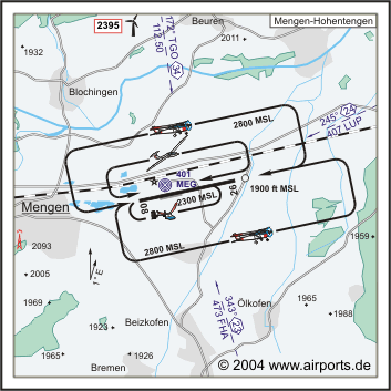
Mengen Hohentengen Airfield |
 ICAO
Code EDTM ICAO
Code EDTM
Name MENGEN - Hohentengen
Land Deutschland
Bundesland Baden-Württemberg
Letzte Änderung 22. August 2004
Kategorie Verkehrslandeplatz / Public Airfield
Betreiber / Operator Flugplatz Mengen GmbH
Lage / Location 1.6 NM E Mengen
Nachtflug / NVFR NVFR
LFZ / ACFT Bis / up to 5700 kg, 14000 kg PPR, HEL 6000 kg, HEL SAR 14000
kg
Helicopter Ja / Yes
Motorsegler / GLDP Ja / Yes
Segelflugzeuge / GLD Ja / Yes
Ballone Ja / Yes
UL Ja / Yes
H-GLD PPR
Summer 0700-SS+30/1800, 0330-0700 und/and SS+30/1800-2000 PPR
Winter 0800-SS+30/1900, 0430-0800 und/and SS+30/1900-2100 PPR
O/T PPR
Keine Starts und Landungen/no DEP and LDG 2100-0430 (2000-0330) Keine
Starts/No DEP 1900-2100 (1800-2000) Weitere Einschränkungen siehe
AD 1-6/ additional restrictions see AD 1-6
Luftaufsicht / OPS +49 (0)7572 / 711047, Fax 711049
PPR +49 (0)7572 / 711047, Fax 711049
AIS AIS-Centre EDDZ, +49 (0)69 / 78072500
ACC LSZH +49 (0)0411 / 8163908
MET (0190) 077225
Gafor 72
Zoll / Customs O/R 2 HR, Zollabfertigung nur für Personenbeförderung
im nicht gewerblichen Verkehr oder Gelegenheitsverkehr. / Custom clearance
for passenger transportation in non-commecial or non-scheduled traffic
only
Fuel 100 LL, Jet A1, Super plus
Oil 80, 100, D 80, D 100, 15W50
Hangar Beschränkt / Limited
Höhe / Elevation 1819 ft / 554 m
FIS Zürich Information 124.700
VDF / QDM 122.375
Rufzeichen / Call sign Mengen Info
Frequenz Tower 122.375 EN/GE
NAV Aids ABN NDB MEG 401 am Platz/at field 173°/34 NM from TGO VORTAC
112.50/Ch 72 246°/24 NM from LUP 407 347°/24 NM from FHA NDB 473
Koordinaten 48 03, 23 N / 09 22, 37 E
Platzrunde / Traffic circuit N/S 2800
Landebahnen / RWY 1
RWY 1601 x 30 m, CONCRETE
RWY 08 TKOF 1566 m; LDG 1301 m
RWY 26 TKOF 1301 m; LDG 1566 m
MTOW 5700 kg, 14000 kg PPR, HEL 6000 kg
Bemerkungen / Remarks Wohngebiete meiden! GLD! UL-Betrieb!
Restaurant Ja
Adresse
Postfach 440
Fon +49 (0)7571 / 102290
URL: http://www.airports.de/airport.php?ICAO=EDTM
Images and information placed
above are from http://www.airports.de/airport.php?ICAO=EDTM
We thank them for the data!
| General Info
|
| Country |
Germany
|
| ICAO ID |
EDTM
|
| Time |
UTC+1(+2DT)
|
| Latitude |
48.053833
48° 03' 13.80" N
|
| Longitude |
9.372833
009° 22' 22.20" E
|
| Elevation |
1820 feet
555 meters
|
| Type |
Civil
|
| Magnetic Variation |
001° E (01/05)
|
| Beacon |
Yes
|
| Operating Agency |
CIVIL GOVERNMENT, (LANDING FEES AND DIPLOMATIC CLEARANCE MAY BE REQUIRED)
|
| Alternate Name |
MENGEN
|
| Operating Hours |
SEE REMARKS FOR OPERATING HOURS OR COMMUNICATIONS FOR POSSIBLE HOURS
|
| Daylight Savings Time |
Last Sunday in March to last Sunday in October
|
| Communications
|
| INFO |
122.375
|
| ZURICH INFO |
124.7
|
| Runways
|
ID
|
Dimensions |
Surface |
PCN |
ILS
|
| 08/26 |
5253 x 98 feet
1601 x 30 meters |
CONCRETE. |
- |
NO
|
| Navaids
|
| Type |
ID |
Name |
Channel |
Freq |
Distance From Field |
Bearing From Navaid
|
| NDB |
MEG |
MENGEN |
- |
401 |
At Field |
-
|
| Supplies/Equipment
|
| Fuel |
Jet A1, without icing nhibitor.
100/130 MIL Spec, low lead, aviation gasoline (BLUE)
|
| Remarks
|
| CSTMS/IMG |
Avbl 2 hr O/R, fone C(07572) 1202.
|
| FUEL |
(NC-100LL, A1)
|
| NS ABTMT |
No dep or ldg 2100-0430Z++, No dep 1900-2100Z++.
|
| OPR HOURS |
Opr 0800Z++-SS+30 but not later than 1900Z++, 0430-0800Z++ and SS+30/1900-2100Z++ PPR. Fone C(07572) 1202.
|
| RSTD |
Rdo ctc must be estab at least 5 min prior to arr. AUW31 PPR.
|
Runway 08/26
5253 x 98 feet
1601 x 30 meters
| Runway 08
|
| Surface |
CONCRETE.
|
| True Heading |
079.0
|
| Latitude |
48.052411
48° 03' 08.68" N
|
| Longitude |
9.362306
009° 21' 44.30" E
|
| Elevation |
1820.0 feet
555 meters
|
| Slope |
-0.2°
|
| Landing Distance |
4268 feet
1301 meters
|
| Takeoff Distance |
5253 feet
1601 meters
|
| Displaced Threshold Length |
985 feet
300 meters
|
| Lighting System |
HIRL
REIL |
| Runway 26
|
| Surface |
CONCRETE.
|
| True Heading |
259.0
|
| Latitude |
48.055253
48° 03' 18.91" N
|
| Longitude |
9.383361
009° 23' 00.10" E
|
| Elevation |
1810.0 feet
552 meters
|
| Slope |
0.2°
|
| Landing Distance |
5138 feet
1566 meters
|
| Takeoff Distance |
5253 feet
1601 meters
|
| Displaced Threshold Length |
115 feet
35 meters
|
| Lighting System |
HIRL
REIL
M |
Navaids
| MENGEN
|
| Type |
ID |
Channel |
Freq |
Country |
State
|
| NDB |
MEG |
- |
401 |
Germany |
-
|
| Latitude |
Longitude |
Airport
|
48.054350
48° 03' 15.66" N |
9.367547
009° 22' 03.17" E |
EDTM |
The content above was published at Airports-Worldwide.com in 2005.
We don't guarantee the information is fresh and accurate. The data may be wrong or outdated.
For more up-to-date information please refer to other sources.
|
|


