|
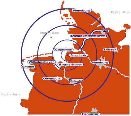 In the area between the rivers Elbe and Weser the Sea-Airport
Cuxhaven/Nordholz was recently taken into service.
It is located in close proximity to the maritime ports of Bremerhaven
and Cuxhaven. The Sea-Airport is focussed on international air transport.
By virtue of co-operation with the port of Cuxhaven it has at its disposal
all the attributes of a
First Point of Entry for dealing with freight.
The Sea-Airport Cuxhaven/Nordholz is making use of the runway and taxiways
as well as the landing procedures and aproach and runway lighting of the
naval air base Nordholz.
The runway with a length of almost 3000m equipped with the instrument
landing system ILS CAT 1 allows intercontinental air traffic to be handled.
The Sea-Airport is equipped in accordance with ICAO standards and connected
to the international SITA information network.
MISSION:
Our engagement for the airport of Cuxhaven/Nordholz follows the following
ideas:
We will complement infrastructure of traffic within the Elbe / Weser-
area by offering an additional und attractive traffic connection for the
economy and tourism in kind of an airport.
We consider the existing infrastructure of the runway as a macro economical
national wealth which can be used in addition for the civil airport.
We will strengthen our regional position within the logistic chain of
air cargo to European and intercontinental destinations.
We will offer attractive flight connections for regular service and charter
flights.
We will offer individual and demand-oriented service to our customers.
We will support the development of the adjoining industrial and commercial
area.
We will create demanding jobs and value added for the region.
ICAO Code ETMN
Name NORDHOLZ
Land Deutschland
Bundesland Niedersachsen
Letzte Änderung 15. September 2004
Kategorie Ziviler Verkehrsflughafen unter Mitbenut
Betreiber / Operator Flughafen - Betriebsgesellschaft Cuxhafen/Nordholz
mbH
Lage / Location 1 NM SE Nordholz
LFZ / ACFT Bis / up to PCN 4E 100
Helicopter Ja / Yes
Summer Mon-Thu 0600-1500, Fri 0600-1100, PPR Mon-Thu 0500-0600, 1500-1800,
Fri 0500-0600, 1100-1800, Sat, Sun, HOL 0600-0730, 0830-1000, 1330-1500
Winter Mon-Thu 0700-1600, Fri 0700-1200, PPR Mon-Thu 0600-0700, 1600-1900,
Fri 0600-0700, 1200-1900, Sat Sun HOL 0700-0830, 0930-1100, 1430-1600
O/T PPR
Luftaufsicht / OPS +49 (0)4741 / 18180, Fax 181818
AIS AIS-Centre +49 (0)69 / 78072500
MET (0190) 077221
Gafor 5
Zoll / Customs PPR
Fuel Jet A 1, 100 LL,
Oil alle Sorten PPR
Hangar Nein / No
Höhe / Elevation 74 ft / 22 m
FIS Bremen Information 125.100
Rufzeichen / Call sign Nordholz Tower
Frequenz Tower 131.250 EN/GE 122.100
NAV Aids 134°/36 NM from DHE 116.30 342°/27 NM from WSR 112.90
259°/6 NM from NDO 372
Koordinaten 53 46,06 N / 08 39,51 E
Landebahnen / RWY 1
RWY 2439 x 45 m, CONCRETE
RWY 08 TKOF 2439 m; LDG 2439 m
RWY 26 TKOF 2439 m; LDG 2439 m
MTOW LCN 120
Bemerkungen / Remarks Wohngebiete meiden
Nordholz (Sea) Airport
Flughafen - Betriebsgesellschaft Cuxhaven/Nordholz mbH
Walter Carstens Str.
27637 Nordholz
Germany
Telefon: +49.47 41.18 18 - 0
Telefax: +49.47 41.18 18 - 18
E-Mail: mail at sea-airport com
URL: http://www.sea-airport.de/
Images and information placed
above are from http://www.airports.de/airport.php?ICAO=ETMN
http://www.sea-airport.de/
We thank them for the data!
| General Info
|
| Country |
Germany
|
| ICAO ID |
ETMN
|
| Time |
UTC+1(+2DT)
|
| Latitude |
53.767667
53° 46' 03.60" N
|
| Longitude |
8.658500
008° 39' 30.60" E
|
| Elevation |
74 feet
23 meters
|
| Type |
Joint (Civil and Military)
|
| Magnetic Variation |
000° E (01/05)
|
| Beacon |
Yes
|
| Operating Agency |
GERMAN NAVY
|
| Operating Hours |
SEE REMARKS FOR OPERATING HOURS OR COMMUNICATIONS FOR POSSIBLE HOURS
|
| International Clearance Status |
Airport of Entry
|
| Daylight Savings Time |
Last Sunday in March to last Sunday in October
|
| Communications
|
| TWR |
142.9
122.1
343.4
257.8
(131.25 civ tfc)
|
| BREMEN RADAR |
124.075
338.8
|
| WING OPS |
301.025
|
| RADAR APP |
123.3
129.85
141.6
249.45
344.0
|
| BREMEN INFO |
125.1
376.7
|
| Communications Remarks |
|
| DIR |
MP 0700-0800Z++ Fri.
|
| Runways
|
ID
|
Dimensions |
Surface |
PCN |
ILS
|
| 08/26 |
8002 x 148 feet
2439 x 45 meters |
CONCRETE. |
- |
YES
|
| Navaids
|
| Type |
ID |
Name |
Channel |
Freq |
Distance From Field |
Bearing From Navaid
|
| TACAN |
NDO |
NORDHOLZ |
118X |
- |
At Field |
-
|
| NDB |
NDO |
NORDHOLZ |
- |
372 |
5.4 NM |
258.5
|
| Supplies/Equipment
|
| Fuel |
JP-8, SemiKeroscene MIL Spec T-83133, without icing inhibitor
|
| Oil |
O-148, MIL L 7808 (Synthetic Base), Turboprop/Turboshaft Engine
O-149, Aircraft Turbine Engine Synthetic 7.5c St
|
| Other Fluids |
PRESAIR, Air Compressors rated 3,000PSI or more
OXRB, Oxygen replacement bottles
|
| JASU |
RST-180
75kva AC 115/200v 400hz AIR 145-155lb/min at 47-51 psi
|
| Remarks
|
| A-GEAR |
Apch end engagement O/R 10 min.
|
| CAUTION |
Bird haz.
|
| FLUID |
PRESAIR OXRB
|
| FUEL |
J8
|
| JASU |
1(G-40) 1(RST-180)
|
| LGT |
ABn flg W/green.
|
| MISC |
Rwy 08-26 902' swy both ends. Rwy 08-26 TODA 8904'. Fone C04741-94-0 Base OPS extn 1528, 1529, Fax 1656; Wing OPS (for PPR) extn 1765, 1766; IVSN 312-1154.
|
| OIL |
O-148-149
|
| OPR HOURS |
Opr 0700-1600Z++ Mon-Thu, 0700-1200Z++ Fri, clsd hol.
|
| RSTD |
Practice apch proh 1100-1300Z++.
|
Runway 08/26
8002 x 148 feet
2439 x 45 meters
| Runway 08
|
| Surface |
CONCRETE.
|
| True Heading |
078.0
|
| Latitude |
53.765450
53° 45' 55.62" N
|
| Longitude |
8.640389
008° 38' 25.40" E
|
| Elevation |
69.0 feet
21 meters
|
| Slope |
-0.4°
|
| Landing Distance |
8002 feet
2439 meters
|
| Takeoff Distance |
8904 feet
2714 meters
|
| Overrun Length |
902 feet
275 meters
|
| Overrun Surface |
CONCRETE.
|
| Lighting System |
SF
CL
HIRL
BP
PAPI |
| Runway 26
|
| Surface |
CONCRETE.
|
| True Heading |
258.0
|
| Latitude |
53.769881
53° 46' 11.57" N
|
| Longitude |
8.676614
008° 40' 35.81" E
|
| Elevation |
39.0 feet
12 meters
|
| Slope |
0.4°
|
| Landing Distance |
8002 feet
2439 meters
|
| Takeoff Distance |
8904 feet
2714 meters
|
| Overrun Length |
902 feet
275 meters
|
| Overrun Surface |
CONCRETE.
|
| Lighting System |
SF
CL
HIRL
BP
PAPI |
Navaids
| NORDHOLZ
|
| Type |
ID |
Channel |
Freq |
Country |
State
|
| TACAN |
NDO |
118X |
- |
Germany |
-
|
| Latitude |
Longitude |
Airport
|
53.769000
53° 46' 08.40" N |
8.653500
008° 39' 12.60" E |
ETMN |
Navaids
| NORDHOLZ
|
| Type |
ID |
Channel |
Freq |
Country |
State
|
| NDB |
NDO |
- |
372 |
Germany |
-
|
| Latitude |
Longitude |
Airport
|
53.785167
53° 47' 06.60" N |
8.806167
008° 48' 22.20" E |
ETMN |
The content above was published at Airports-Worldwide.com in 2005.
We don't guarantee the information is fresh and accurate. The data may be wrong or outdated.
For more up-to-date information please refer to other sources.
|


