|
 ICAO
Code EDUW ICAO
Code EDUW
Name TUTOW
Land Deutschland
Bundesland Mecklenburg-Vorpommern
Letzte Änderung 31. März 2005
Kategorie Verkehrslandeplatz / Public Airfield
Betreiber / Operator Karl-Alfred Feußner
Adresse Flgplatz Tutow, Flughafenring 31
Lage / Location 6 NM E Demmin
LFZ / ACFT Bis / up to 14000 kg
Helicopter Ja / Yes
Motorsegler / GLDP Ja / Yes
Segelflugzeuge / GLD Ja / Yes
Ballone Ja / Yes
UL Ja / Yes
Fallschirmspringen / PJE Ja / Yes
Summer 0700-1600
Winter 0900-1400
O/T PPR
Luftaufsicht / OPS +49 (0)39999 / 76843
PPR +49 (0)39999 / 76843
AIS EDDB +49 (0)30 / 60918250
MET (0190) 077222
Gafor 12
Zoll / Customs Nein / No
Fuel Super O/R
Oil Nein / No
Hangar Nein / No
Höhe / Elevation 23 ft / 8 m
FIS Berlin Information 126.350
Rufzeichen / Call sign Tutow Info
Frequenz Tower 130.125 GE
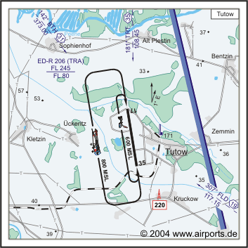
NAV Aids "181°/35NM from ""TRT"" 108.45 307°
16 NM from ""FLD"" 117.15"
Koordinaten 53 55, 32 N / 13 13, 13 E
Platzrunde / Traffic circuit W 800
Landebahnen / RWY 2
RWY 2200 x 60 m, CONCRETE
RWY 17 TKOF 2200 m; LDG 2200 m
RWY 35 TKOF 2200 m; LDG 2200 m
MTOW 14000 kg
RWY II 500 x 30 m, Gras
RWY 17 TKOF 500 m; LDG 500 m
RWY 35 TKOF 500 m; LDG 500 m
MTOW RWY II 2000 kg
Address:
ZIP / City D-58256
Ennepetal
Fon +49 (0)39999 / 76843
Images and information placed above are from
http://www.airports.de/airport.php?ICAO=EDUW
We thank them for the data!
| General Info
|
| Country |
Germany
|
| ICAO ID |
EDUW
|
| Time |
UTC+1(+2DT)
|
| Latitude |
53.922000
53° 55' 19.20" N
|
| Longitude |
13.218833
013° 13' 07.80" E
|
| Elevation |
23 feet
7 meters
|
| Magnetic Variation |
002° E (01/05)
|
| Operating Agency |
CIVIL GOVERNMENT, (LANDING FEES AND DIPLOMATIC CLEARANCE MAY BE REQUIRED)
|
| Alternate Name |
DEMMIN
|
| Operating Hours |
SEE REMARKS FOR OPERATING HOURS OR COMMUNICATIONS FOR POSSIBLE HOURS
|
| Daylight Savings Time |
Last Sunday in March to last Sunday in October
|
| Communications
|
| INFO |
130.125
|
| BERLIN INFO |
126.35
|
| Runways
|
| ID |
Dimensions |
Surface |
PCN |
ILS
|
| 17/35 |
7218 x 197 feet
2200 x 60 meters |
CONCRETE. |
- |
NO
|
| 17L/35R |
1640 x 98 feet
500 x 30 meters |
GRASS OR EARTH NOT GRADED OR ROLLED. |
- |
NO
|
| Supplies/Equipment
|
| Fuel |
Aviation Gasoline (AVGAS), octane unknown.
|
| Remarks
|
| OPR HOURS |
Opr 0900-1400Z (0700-1600Z DT) O/T PPR.
|
Runway 17/35
7218 x 197 feet
2200 x 60 meters
| Runway 17
|
| Surface |
CONCRETE.
|
| True Heading |
171.0
|
| Latitude |
53.931981
53° 55' 55.13" N
|
| Longitude |
13.216114
013° 12' 58.01" E
|
| Landing Distance |
7218 feet
2200 meters
|
| Takeoff Distance |
7218 feet
2200 meters
|
| Runway 35
|
| Surface |
CONCRETE.
|
| True Heading |
351.0
|
| Latitude |
53.912464
53° 54' 44.87" N
|
| Longitude |
13.221431
013° 13' 17.15" E
|
| Landing Distance |
7218 feet
2200 meters
|
| Takeoff Distance |
7218 feet
2200 meters
|
Runway 17L/35R
1640 x 98 feet
500 x 30 meters
| Runway 17L
|
| Surface |
GRASS OR EARTH NOT GRADED OR ROLLED.
|
| True Heading |
170.0
|
| Latitude |
0.000000
-
|
| Longitude |
0.000000
-
|
| Landing Distance |
1640 feet
500 meters
|
| Takeoff Distance |
1640 feet
500 meters
|
| Runway 35R
|
| Surface |
GRASS OR EARTH NOT GRADED OR ROLLED.
|
| True Heading |
350.0
|
| Latitude |
0.000000
-
|
| Longitude |
0.000000
-
|
| Landing Distance |
1640 feet
500 meters
|
| Takeoff Distance |
1640 feet
500 meters
|
The content above was published at Airports-Worldwide.com in 2005.
We don't guarantee the information is fresh and accurate. The data may be wrong or outdated.
For more up-to-date information please refer to other sources.
|


