 |
 |
|
||||
|
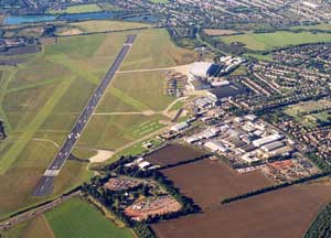
The airport provides access to the North, East and City of London as well as the fast growing businesses in the East Anglia region, it has excellent public transport connections and is close to the motorway network. Cambridge City Airport has excellent road and rail links to destinations throughout the uk. Situated close to the M11 and A14 the M25 is only 40 minutes away. Cambridge City Centre and the main line railway station are about 3 miles from the airport and are linked by a frequent bus service. A short and frequent train service - 45 minute journey time - makes London very accessible.
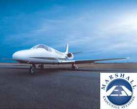
Cambridge City Airport Images and information placed above are from http://airline-tickets.co.uk/cambridge-city-airport.htm We thank them for the data!
Runway 05/236207 x 151 feet
|
||||||||||||||||||||||||||||||||||||||||||||||||||||||||||||||||||||||||||||||||||||||||||||||||||||||||||||||||||||||||||||||||||||||||||||||||||||||||||||||||||||||||||||||||||||||||||||||||||||||||||||||||||||||||||||||||||||||||||||||||||||||||||||||||||||||||||||||||||||||||||||
| Runway 05 | |
|---|---|
| Surface | ASPHALT |
| True Heading | 050.0 |
| Latitude | 52.199761 52° 11' 59.14" N |
| Longitude | 0.164867 000° 09' 53.52" E |
| Elevation | 35.0 feet 11 meters |
| Slope | 0.2° |
| Landing Distance | 5498 feet 1676 meters |
| Takeoff Distance | 6207 feet 1892 meters |
| Displaced Threshold Length | 709 feet 216 meters |
| Lighting System | HIRL
S PAPI |
| Runway 23 | |
|---|---|
| Surface | ASPHALT |
| True Heading | 230.0 |
| Latitude | 52.210697 52° 12' 38.51" N |
| Longitude | 0.186056 000° 11' 09.80" E |
| Elevation | 47.0 feet 14 meters |
| Slope | -0.2° |
| Landing Distance | 5730 feet 1747 meters |
| Takeoff Distance | 6207 feet 1892 meters |
| Displaced Threshold Length | 477 feet 145 meters |
| Lighting System | HIRL
J PAPI |
| Runway 05R | |
|---|---|
| Surface | GRASS OR EARTH NOT GRADED OR ROLLED. |
| True Heading | 050.0 |
| Latitude | 52.203089 52° 12' 11.12" N |
| Longitude | 0.175594 000° 10' 32.14" E |
| Elevation | 36.0 feet 11 meters |
| Slope | 0.0° |
| Landing Distance | 2949 feet 899 meters |
| Takeoff Distance | 2949 feet 899 meters |
| Runway 23L | |
|---|---|
| Surface | GRASS OR EARTH NOT GRADED OR ROLLED. |
| True Heading | 230.0 |
| Latitude | 52.208297 52° 12' 29.87" N |
| Longitude | 0.185667 000° 11' 08.40" E |
| Elevation | 36.0 feet 11 meters |
| Slope | 0.0° |
| Landing Distance | 2949 feet 899 meters |
| Takeoff Distance | 2949 feet 899 meters |
| Runway 10 | |
|---|---|
| Surface | GRASS OR EARTH NOT GRADED OR ROLLED. |
| True Heading | 100.0 |
| Latitude | 52.203258 52° 12' 11.73" N |
| Longitude | 0.168661 000° 10' 07.18" E |
| Elevation | 30.0 feet 9 meters |
| Slope | 0.2° |
| Landing Distance | 2293 feet 699 meters |
| Takeoff Distance | 2293 feet 699 meters |
| Runway 28 | |
|---|---|
| Surface | GRASS OR EARTH NOT GRADED OR ROLLED. |
| True Heading | 280.0 |
| Latitude | 52.202178 52° 12' 07.84" N |
| Longitude | 0.178747 000° 10' 43.49" E |
| Elevation | 35.0 feet 11 meters |
| Slope | -0.2° |
| Landing Distance | 2293 feet 699 meters |
| Takeoff Distance | 2293 feet 699 meters |
| CAMBRIDGE | |||||
|---|---|---|---|---|---|
| Type | ID | Channel | Freq | Country | State |
| NDB | CAM | - | 332.5 | United Kingdom | - |
| Latitude | Longitude | Airport |
| 52.210850 52° 12' 39.06" N |
0.182792 000° 10' 58.05" E |
EGSC |
The content above was published at Airports-Worldwide.com in 2005.
We don't guarantee the information is fresh and accurate. The data may be wrong or outdated.
For more up-to-date information please refer to other sources.

 |
|
Copyright 2004-2026 © by Airports-Worldwide.com, Vyshenskoho st. 36, Lviv 79010, Ukraine Legal Disclaimer |
 Cambridge City Airport is a regional airport with a business focus three miles from the world famous Cambridge University and City.
 The Airport, Newmarket Road,