 |
 |
|
||||
|
The airport comes equipped with a bureau de change (ph: 01392 446 446), an ATM and a travel agent. The single terminal's ten check-in desks ensure fast and efficient check-in and boarding. A conference room is available with a seating capacity of 40 people and catering and presentation equipment provided (ph: +44 (0) 1392 367 433).
Facilities for disabled passengers include specially designed toilets, induction loops for the hard of hearing, low-level phones, ramps, an Ambulift, and information cards in Braille (tel: + 44 (0) 1392 367 433). There is a direct bus link between the terminal and Exeter city centre. Exeter St Davids Station lies on the London (Paddington) to Plymouth and Cornwall line, while Exeter Central Station lies on the London (Waterloo) to Exmouth line (ph: 08457 48 49 50).
Airport information: +44 (1392) 367433  Exeter International Airport:
Exeter, Devon, UK EX5 2BD tel: 01392 367 433 fax: 01392 364 593 E-mail: marketing at exeter-airport co uk WWW: http://www.exeter-airport.co.uk/ Images and information placed above are from http://www.robinsongroup.co.uk/slideshow_ea.htm http://www.worldparking.co.uk/ We thank them for the data!
Runway 08/266834 x 151 feet
|
|||||||||||||||||||||||||||||||||||||||||||||||||||||||||||||||||||||||||||||||||||||||||||||||||||||||||||||||||||||||||||||||||||||||||||||||||||||||||
| Runway 08 | |
|---|---|
| Surface | ASPHALT |
| True Heading | 076.0 |
| Latitude | 50.732042 50° 43' 55.35" N |
| Longitude | -3.428144 003° 25' 41.32" W |
| Elevation | 99.0 feet 30 meters |
| Slope | 0.0° |
| Landing Distance | 6801 feet 2073 meters |
| Takeoff Distance | 6834 feet 2083 meters |
| Displaced Threshold Length | 33 feet 10 meters |
| Lighting System | HIRL
X PAPI |
| Runway 26 | |
|---|---|
| Surface | ASPHALT |
| True Heading | 256.0 |
| Latitude | 50.736533 50° 44' 11.52" N |
| Longitude | -3.399503 003° 23' 58.21" W |
| Elevation | 102.0 feet 31 meters |
| Slope | 0.0° |
| Landing Distance | 6717 feet 2047 meters |
| Takeoff Distance | 6834 feet 2083 meters |
| Displaced Threshold Length | 117 feet 36 meters |
| Lighting System | HIRL
N PAPI |
The content above was published at Airports-Worldwide.com in 2005.
We don't guarantee the information is fresh and accurate. The data may be wrong or outdated.
For more up-to-date information please refer to other sources.

 |
|
Copyright 2004-2026 © by Airports-Worldwide.com, Vyshenskoho st. 36, Lviv 79010, Ukraine Legal Disclaimer |
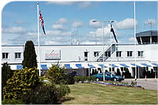 Exeter
International Airport is an important gateway to southwest England and
offers numerous European flights, trans-Atlantic connections and holiday
charter flights.
Exeter
International Airport is an important gateway to southwest England and
offers numerous European flights, trans-Atlantic connections and holiday
charter flights.
 The Food Village provides a good variety of food and refreshments, while there is a cafe and bar in the departures area. Books Plus offers newspapers, magazines, gifts, books and CDs, while after security there is an extensive duty free shop.
 Taxis may be pre-booked at Corporate Cars on +44 (0) 1395 233 728. The airport is well signposted along the A30, which joins the M5 motorway at Junction 29. Both short- and long-term parking are available (ph: 01392 361 028).