 |
 |
|
||||
|
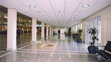
The single terminal comes equipped with ATMs, a left luggage facility, lost property service, baby change rooms, and a post office. The airport cafeteria is located on the first floor and offers meals, snacks, refreshments and a bar service. There is a small cafe and bar in the departure lounge. Opposite the cafeteria is a comprehensive shop stocking newspapers, books, and gifts. Fax, photocopy, and meeting room facilities may be accessed through the airport information desk during normal office hours. The desk is situated in the main hall (ph: +44 01624 821600) and also provides a Tourist Information Service. Facilities for disabled passengers include specially designed toilets, dedicated parking, induction loops, low-level phones, and lifts. Isle of Man Transport operates a bus service from the airport to several surrounding destinations (ph: +44 1624 662525). Taxis are available from outside the terminal building (ph: +44 01624 - 821678). Car hire is also available. No point on the island is more than an hour's drive away, with the airport well signposted on all main roads. The main car park is found opposite the terminal building. Airport information: +44 01624 821600
WWW: http://www.gov.im/airport/
Images and information placed above are from http://www.worldparking.co.uk/uk-airports/isle-of-man.php We thank them for the data!
Runway 03/214121 x 151 feet
|
|||||||||||||||||||||||||||||||||||||||||||||||||||||||||||||||||||||||||||||||||||||||||||||||||||||||||||||||||||||||||||||||||||||||||||||||||||||||||||||||||||||||||||||||||||||||||||||||||||||||||||||||||||||||||||||||||||||||||||||||||||||||
| Runway 03 | |
|---|---|
| Surface | ASPHALT |
| True Heading | 028.0 |
| Latitude | 54.077222 54° 04' 38.00" N |
| Longitude | -4.631944 004° 37' 55.00" W |
| Elevation | 23.0 feet 7 meters |
| Slope | 0.7° |
| Landing Distance | 4026 feet 1227 meters |
| Takeoff Distance | 4121 feet 1256 meters |
| Displaced Threshold Length | 95 feet 29 meters |
| Lighting System | HIRL
PAPI |
| Runway 21 | |
|---|---|
| Surface | ASPHALT |
| True Heading | 208.0 |
| Latitude | 54.087222 54° 05' 14.00" N |
| Longitude | -4.623333 004° 37' 24.00" W |
| Elevation | 52.0 feet 16 meters |
| Slope | -0.7° |
| Landing Distance | 4121 feet 1256 meters |
| Takeoff Distance | 4121 feet 1256 meters |
| Lighting System | HIRL
BO PAPI |
| Runway 08 | |
|---|---|
| Surface | ASPHALT |
| True Heading | 078.0 |
| Latitude | 54.081667 54° 04' 54.00" N |
| Longitude | -4.636944 004° 38' 13.00" W |
| Landing Distance | 4800 feet 1463 meters |
| Takeoff Distance | 5751 feet 1753 meters |
| Displaced Threshold Length | 951 feet 290 meters |
| Lighting System | CL
HIRL BO PAPI |
| Runway 26 | |
|---|---|
| Surface | ASPHALT |
| True Heading | 258.0 |
| Latitude | 54.084722 54° 05' 05.00" N |
| Longitude | -4.611111 004° 36' 40.00" W |
| Landing Distance | 5292 feet 1613 meters |
| Takeoff Distance | 5751 feet 1753 meters |
| Displaced Threshold Length | 459 feet 140 meters |
| Lighting System | CL
HIRL J PAPI |
| ISLE OF MAN | |||||
|---|---|---|---|---|---|
| Type | ID | Channel | Freq | Country | State |
| VOR-DME | IOM | 059X | 112.2 | Man, Isle of | - |
| Latitude | Longitude | Airport |
| 54.066867 54° 04' 00.72" N |
-4.763475 004° 45' 48.51" W |
EGNS |
The content above was published at Airports-Worldwide.com in 2005.
We don't guarantee the information is fresh and accurate. The data may be wrong or outdated.
For more up-to-date information please refer to other sources.

 |
|
Copyright 2004-2026 © by Airports-Worldwide.com, Vyshenskoho st. 36, Lviv 79010, Ukraine Legal Disclaimer |
 The busy Isle of Man Airport handles over a million passengers annually flying to and from destinations throughout the UK and Europe as well as several trans-Atlantic flights.
 Isle of Man Airport