|
 |
|
||||
|
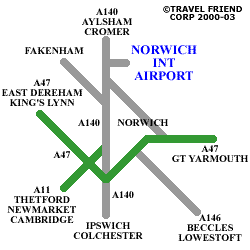
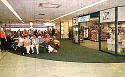
The single terminal comes equipped with a bureau de change, ATM, baby change and nursing mother's rooms, and a children's play area. The airport information desk is situated in main terminal. A shop stocking a wide selection of products is located in the main concourse, while there is extensive duty-free after security. Two bars, a restaurant and a cafe are available in the main concourse and departure lounge. An executive lounge offers complimentary refreshments and newspapers, as well as Internet, phone and fax facilities. Facilities for disabled passengers include specially designed toilets, wide entry and exit points, and easy access to all facilities due to the terminal's single level. Passengers should advise their airline of any special needs in advance. Norwich train station is easily reached by taxi, from where there are regular services to and from London's Liverpool St station. Bus no.24 operates regularly between the airport and Norwich city centre (ph: + 44 (0) 1603 622 800). The airport is well signposted along the A140, and is close to the A11 (Cambridge). Car hire is available from the terminal. Both short- and long-stay parking is available (NCP: 0800 128 128). Airport information: +44 (0) 1603 420653
Images and information placed above are from http://www.worldparking.co.uk/uk-airports/norwich-international.php http://www.travel-friend.co.uk/airports/airports_norwich.htm http://www.455th.ukpc.net/tomfeise/455th/458th.htm We thank them for the data!
Runway 04/224154 x 148 feet
|
|||||||||||||||||||||||||||||||||||||||||||||||||||||||||||||||||||||||||||||||||||||||||||||||||||||||||||||||||||||||||||||||||||||||||||||||||||||||||||||||||||||||||||||||||||||
| Runway 04 | |
|---|---|
| Surface | ASPHALT |
| True Heading | 037.0 |
| Latitude | 52.674286 52° 40' 27.43" N |
| Longitude | 1.282081 001° 16' 55.49" E |
| Elevation | 107.0 feet 33 meters |
| Slope | -0.1° |
| Landing Distance | 4154 feet 1266 meters |
| Takeoff Distance | 4154 feet 1266 meters |
| Runway 22 | |
|---|---|
| Surface | ASPHALT |
| True Heading | 217.0 |
| Latitude | 52.683436 52° 41' 00.37" N |
| Longitude | 1.293206 001° 17' 35.54" E |
| Elevation | 101.0 feet 31 meters |
| Slope | 0.1° |
| Landing Distance | 4154 feet 1266 meters |
| Takeoff Distance | 4154 feet 1266 meters |
| Runway 09 | |
|---|---|
| Surface | ASPHALT |
| True Heading | 090.0 |
| Latitude | 52.675831 52� 40' 32.99" N |
| Longitude | 1.269053 001� 16' 08.59" E |
| Elevation | 117.0 feet 36 meters |
| Slope | -0.2� |
| Landing Distance | 6040 feet 1841 meters |
| Takeoff Distance | 6040 feet 1841 meters |
| Lighting System | CL
HIRL BF PAPI |
| Runway 27 | |
|---|---|
| Surface | ASPHALT |
| True Heading | 270.0 |
| Latitude | 52.676036 52� 40' 33.73" N |
| Longitude | 1.296272 001� 17' 46.58" E |
| Elevation | 106.0 feet 32 meters |
| Slope | 0.2� |
| Landing Distance | 6040 feet 1841 meters |
| Takeoff Distance | 6040 feet 1841 meters |
| Lighting System | CL
HIRL BO PAPI |
The content above was published at Airports-Worldwide.com in 2005.
We don't guarantee the information is fresh and accurate. The data may be wrong or outdated.
For more up-to-date information please refer to other sources.

 |
|
Copyright 2004-2026 © by Airports-Worldwide.com, Vyshenskoho st. 36, Lviv 79010, Ukraine Legal Disclaimer |
 Norwich International is a popular airport serving the East Anglia area with numerous scheduled European and UK flights, along with connecting flights to destinations worldwide.