 |
|
Nashua Municipal Airport
Boire Field |
| IATA: ASH – ICAO: KASH – FAA LID: ASH |
| Summary |
| Airport type |
Public |
| Owner |
Nashua Airport Authority |
| Operator |
Nashua Airport Authority |
| Location |
Nashua, New Hampshire |
| Elevation AMSL |
199 ft / 60.7 m |
| Coordinates |
42°46′54″N 071°30′53″W / 42.78167°N 71.51472°W / 42.78167; -71.51472Coordinates: 42°46′54″N 071°30′53″W / 42.78167°N 71.51472°W / 42.78167; -71.51472 |
| Website |
http://www.nashuaairport.com |
| Runways |
| Direction |
Length |
Surface |
| ft |
m |
| 14/32 |
5,501 |
1,677 |
Asphalt |
| Statistics (2009) |
| Aircraft operations |
128,043 |
| Based aircraft |
364 |
| Source: Federal Aviation Administration |
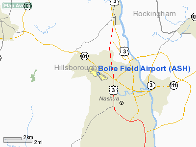
Nashua Municipal Airport (IATA: ASH, ICAO: KASH, FAA LID: ASH), also known as Boire Field, is a public airport located three miles (5 km) northwest of the central business district (CBD) of Nashua, a city in Hillsborough County, New Hampshire, USA.
This general aviation airport covers 392 acres (159 ha) and has one runway. There is space for 441 aircraft located on the field. Air Traffic Control is at the airport from 7:00 a.m. until 9:00 p.m. It has no scheduled commercial service.
Nashua Municipal is one of the busiest airports in New England in terms of take-offs and landings due to its use for flight training by adjacent Daniel Webster College, which maintains more than a dozen single-engine aircraft at the airport.
Frequencies:
- ATIS = 125.1
- Ground Control and Clearance Delivery = 121.8
- Tower (Local) = 133.2
History
The airport dates back to 1934, when the city of Nashua bought a small existing airport, which lacked a hangar and had a grass runway. Over the next several years Nashua, with federal help, paved the 2,000-foot (610 m) runway and put up some buildings. According to the history in the airport Web site, the hangar was constructed from bricks reused from a Nashua factory that burned in 1930 in what was known here as the Crown Hill Fire.
In 1943 it was named Boire Field, after Ensign Paul Boire, who was Nashua's first casualty in World War II.
The Nashua Airport Authority was established to oversee the airport in 1961. The New England Aeronautical Institute was founded here in 1965. The NEIA's Daniel Webster Junior College division was founded in 1967. The two schools merged in 1978 to form the current Daniel Webster College.
The control tower was built in 1972.
The airport was one of the first to operate with a Non-Federal Control Tower in the early 1990s. This type of air traffic service, called a contract tower, is common today.
Airport Services
In addition to the professional pilot flight training offered at Daniel Webster College, the airport has private flight schools offering training and certification in fixed-wing airplanes and helicopters.
Also offered from the Nashua airport is on-demand air charter. One of these providers is Infinity Aviation which operates a number of Hawker mid-size jet aircraft.
There are two FBOs or fixed base operators that provide aircraft servicing, fueling and maintenance and flight planning resources: Infinity Aviation Services and GFW Aeroservices.
The second-floor Midfield Cafe is open for breakfast and lunch on weekends and a few weekdays.
The above content comes from Wikipedia and is published under free licenses – click here to read more.
Location & QuickFacts
| FAA Information Effective: | 2008-09-25 |
| Airport Identifier: | ASH |
| Airport Status: | Operational |
| Longitude/Latitude: | 071-30-53.2000W/42-46-54.3000N
-71.514778/42.781750 (Estimated) |
| Elevation: | 199 ft / 60.66 m (Surveyed) |
| Land: | 400 acres |
| From nearest city: | 3 nautical miles NW of Nashua, NH |
| Location: | Hillsborough County, NH |
| Magnetic Variation: | 16W (1995) |
Owner & Manager
| Ownership: | Publicly owned |
| Owner: | Nashua Airport Authority |
| Address: | 93 Perimeter Road
Nashua, NH 03063 |
| Phone number: | 603-882-0661 |
| Manager: | Roy Rankin |
| Address: | 93 Perimeter Rd
Nashua, NH 03063 |
| Phone number: | 603-882-0661 |
Airport Operations and Facilities
| Airport Use: | Open to public |
| Wind indicator: | Yes |
| Segmented Circle: | Yes |
| Control Tower: | Yes |
| Lighting Schedule: | DUSK-DAWN
ACTVT HIRL RY 14/32 & MALSR RY 14 AFT HRS - CTAF. |
| Beacon Color: | Clear-Green (lighted land airport) |
| Landing fee charge: | No |
| Sectional chart: | New York |
| Region: | ANE - New England |
| Boundary ARTCC: | ZBW - Boston |
| Tie-in FSS: | BGR - Bangor |
| FSS on Airport: | No |
| FSS Toll Free: | 1-800-WX-BRIEF |
| NOTAMs Facility: | ASH (NOTAM-d service avaliable) |
| Federal Agreements: | NGY |
Airport Communications
Airport Services
| Fuel available: | 100LLA1+ |
| Airframe Repair: | MAJOR |
| Power Plant Repair: | MAJOR |
| Bottled Oxygen: | HIGH/LOW |
| Bulk Oxygen: | HIGH/LOW |
Runway Information
Runway 14/32
| Dimension: | 5501 x 100 ft / 1676.7 x 30.5 m |
| Surface: | ASPH, Fair Condition |
| Weight Limit: | Single wheel: 62000 lbs.
Dual wheel: 80000 lbs.
Dual tandem wheel: 133000 lbs. |
| Edge Lights: | High |
| |
Runway 14 |
Runway 32 |
| Longitude: | 071-31-24.2190W | 071-30-22.1519W |
| Latitude: | 42-47-09.0077N | 42-46-39.6542N |
| Elevation: | 199.00 ft | 186.00 ft |
| Alignment: | 123 | 127 |
| ILS Type: | ILS
| |
| Traffic Pattern: | Left | Left |
| Markings: | Precision instrument, Good Condition | Precision instrument, Good Condition |
| Crossing Height: | 51.00 ft | 47.00 ft |
| VASI: | 4-light PAPI on left side | 2-box on left side |
| Visual Glide Angle: | 3.00° | 3.00° |
| Approach lights: | MALSR | |
| Runway End Identifier: | | Yes |
| Obstruction: | 42 ft tree, 1966.0 ft from runway, 639 ft left of centerline, 42:1 slope to clear | 43 ft tree, 531.0 ft from runway, 295 ft left of centerline, 8:1 slope to clear |
|
Radio Navigation Aids
| ID |
Type |
Name |
Ch |
Freq |
Var |
Dist |
| BVY | FAN MARKER | Beverly | | | | 27.3 nm |
| ORW | FAN MARKER | Canton | | | 15W | 40.7 nm |
| LCI | FAN MARKER | Laconia | | | | 47.3 nm |
| AS | NDB | Chern | | 359.00 | 16W | 4.6 nm |
| DRY | NDB | Derry | | 338.00 | 16W | 7.4 nm |
| FIT | NDB | Fitchburg | | 365.00 | 15W | 17.5 nm |
| CO | NDB | Epsom | | 216.00 | 16W | 20.4 nm |
| SKR | NDB | Shaker Hill | | 251.00 | 16W | 24.6 nm |
| TOF | NDB | Topsfield | | 269.00 | 16W | 26.5 nm |
| LQ | NDB | Lyndy | | 382.00 | 16W | 31.4 nm |
| ORE | NDB | Orange | | 205.00 | 15W | 36.4 nm |
| ESG | NDB | Rollins | | 260.00 | 16W | 40.1 nm |
| LC | NDB | Blnap | | 328.00 | 16W | 45.4 nm |
| IHM | NDB | Mansfield | | 220.00 | 16W | 48.9 nm |
| NZW | TACAN | South Weymouth | 061X | | 15W | 45.8 nm |
| MHT | VOR/DME | Manchester | 091X | 114.40 | 15W | 8.3 nm |
| LWM | VOR/DME | Lawrence | 072X | 112.50 | 15W | 18.7 nm |
| PSM | VOR/DME | Pease | 112X | 116.50 | 16W | 35.1 nm |
| CON | VORTAC | Concord | 076X | 112.90 | 15W | 26.5 nm |
| GDM | VORTAC | Gardner | 043X | 110.60 | 14W | 27.9 nm |
| EEN | VORTAC | Keene | 031X | 109.40 | 14W | 34.3 nm |
| BOS | VORTAC | Boston | 074X | 112.70 | 16W | 34.5 nm |
| BED | VOT | Laurence G Hanscom Fld | | 110.00 | | 21.3 nm |
| BOS | VOT | Boston Logan Intl | | 111.00 | | 32.7 nm |
| ORH | VOT | Worcester | | 108.20 | | 34.7 nm |
Remarks
- ARPT HAS NOISE ABATEMENT PROCEDURES CONTACT AMGR 603-882-0661.
- MIGRATORY BIRDS & WILDLIFE ON & INVOF ARPT.
Images and information placed above are from
http://www.airport-data.com/airport/ASH/
We thank them for the data!
| General Info
|
| Country |
United States
|
| State |
NEW HAMPSHIRE
|
| FAA ID |
ASH
|
| Latitude |
42-46-54.347N
|
| Longitude |
071-30-53.206W
|
| Elevation |
200 feet
|
| Near City |
NASHUA
|
We don't guarantee the information is fresh and accurate. The data may
be wrong or outdated.
For more up-to-date information please refer to other sources.
|
|


