 |
|
Dole - Jura Airport
Aéroport de Dole - Jura |
 |
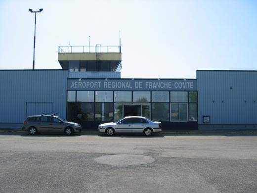
| Aéroport Régional de Franche-Comté |
| IATA: DLE – ICAO: LFGJ
Location of airport in France
|
| Summary |
| Airport type |
Public |
| Operator |
CCI du Jura |
| Serves |
Dole |
| Location |
Tavaux, Jura, France |
| Elevation AMSL |
645 ft / 197 m |
| Coordinates |
47°02′34″N 005°26′06″E / 47.04278°N 5.435°E / 47.04278; 5.435 |
| Website |
AeroportFrancheComte.com |
| Runways |
| Direction |
Length |
Surface |
| m |
ft |
| 05/23 |
2,230 |
7,316 |
Asphalt |
| 05L/23R |
800 |
2,625 |
Grass |
| Sources: French AIP, UAF, DAFIF |
Dole – Jura Airport (French: Aéroport de Dole - Jura) (IATA: DLE, ICAO: LFGJ), also known as Franche-Comté Regional Airport (Aéroport Régional de Franche-Comté), is an airport serving Dole, a commune in the Jura department in the Franche-Comté region in eastern France. The airport is located 7 km (4 NM) southwest of Dole, and southeast of Tavaux. It was formerly known as Dole - Tavaux Airport.
The airport is used for general aviation, with no commercial airline service. Facilities
The airport resides at an elevation of 645 feet (197 m) above mean sea level. It has one paved runway designated 05/23 which measures 2,230 by 45 metres (7,316 × 148 ft). It also has a parallel runway with a grass surface measuring 800 by 50 metres (2,625 × 164 ft).
History
During World War II the airport was used by the German Luftwaffe during the occupation of France as an Air intelligence training facility (Luftnachrichten-Ausbildungs-Regiment 302). It was attacked by the United States Army Air Force on several occasions in the spring of 1944. After the airfield was liberated by Allied forces in early September 1944, the United States Army Air Forces IX Engineer Command repaired the airfield and made it ready for operational use by combat units. The field was made ready by 15 September. It was known as Dole/Tavaux Airfield or Advanced Landing Ground Y-7. Units that were assigned to the airfield were:
- 320th Bombardment Group, 1 April-18 June 1945, B-25 Mitchell (12th AF)
- 324th Fighter Group, 20 September 1944-4 January 1945, P-40 Warhawk (12th AF)
- 371st Fighter Group, 1 October-20 December 1944, P-47 Thunderbolt, (9th AF)
With the end of the war in Europe in May, 1945 the Americans began to withdraw their aircraft and personnel. Control of the airport was returned to French civil authorities on 17 July 1945.
The above content comes from Wikipedia and is published under free licenses – click here to read more.
| General Info
|
| Country |
France
|
| ICAO ID |
LFGJ
|
| Time |
UTC+1(+2DT)
|
| Latitude |
47.039014
47° 02' 20.45" N
|
| Longitude |
5.427250
005° 25' 38.10" E
|
| Elevation |
645 feet
197 meters
|
| Type |
Civil
|
| Magnetic Variation |
000° E (01/06)
|
| Operating Agency |
CIVIL GOVERNMENT, (LANDING FEES AND DIPLOMATIC CLEARANCE MAY BE REQUIRED)
|
| Near City |
Dole
|
| Operating Hours |
NO OPERATING HOURS LISTED
|
| Daylight Saving Time |
Last Sunday in March to last Sunday in October
|
| Communications
|
DOLE TWR
Opr 0700-1900Z++ Mon-Fri; 0800-1200Z++, 1300-1700Z++ Sat, Sun & hol; OT PPR
|
130.775
|
AFIS
Opr 1900-0200Z++ Mon-Fri.
|
130.775
|
| Runways
|
| ID |
Dimensions |
Surface |
PCN |
ILS
|
| 05/23 |
7318 x 148 feet
2231 x 45 meters |
ASPHALT |
- |
YES
|
| Supplies/Equipment
|
| Fuel |
Jet A1, without icing nhibitor.
100/130 MIL Spec, low lead, aviation gasoline (BLUE)
|
| Remarks
|
| CSTMS/AG/IMG |
Avbl O/R to CCI 4 hr PN fr 0700-1900Z++ Mon-Fri; aft 1900Z++ PN rqr before 1100Z++; Sat, Sun, hol 24 hr PN. Fone C03 81 41 41 50.
|
| FUEL |
Avbl 0700-0200Z++ Mon-Fri exc hol. (NC-100LL, A1)
|
| LGT |
PAPI Rwy 05 GS 3.1 MEHT 57', PAPI Rwy 23 GS 3 MEHT 36'.
|
The content above was published at Airports-Worldwide.com in 2010.
We don't guarantee the information is fresh and accurate. The data may be wrong or outdated.
For more up-to-date information please refer to other sources.
|
 |


