 |
|
Tours Val de Loire Airport
Aéroport Tours Val de Loire |
 |
IATA: TUF – ICAO: LFOT
 |
| Summary |
| Airport type |
Public / Military |
| Operator |
Ministère de la Défense (FAF) |
| Serves |
Tours, France |
| Elevation AMSL |
357 ft / 109 m |
| Coordinates |
47°25′55″N 000°43′23″E / 47.43194°N 0.72306°E / 47.43194; 0.72306 |
| Website |
www.Tours.Aeroport.fr |
| Runways |
| Direction |
Length |
Surface |
| m |
ft |
| 02/20 |
2,404 |
7,887 |
Concrete |
| Source: French AIP |
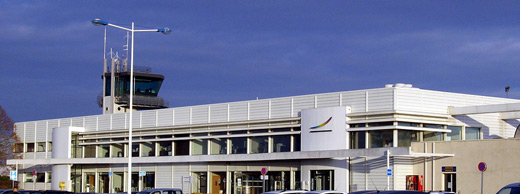
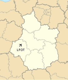
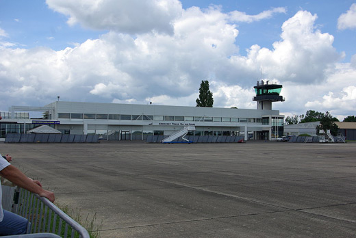
Tours Val de Loire Airport (French: Aéroport Tours Val de Loire) (IATA: TUF, ICAO: LFOT) is an airport in the French department of Indre-et-Loire, 6 km (3.2 NM) north-northeast of the city of Tours in the Loire Valley (Val de Loire). The airport is located partly on the territory of the communes of Tours and Parçay-Meslay.

The airport is open to both national and international carriers, private planes and is certified for both instrument flight and visual flight. It has daily flights to several European destinations operated by Ryanair using Boeing 737-800 aircraft, as well as non-regular flights to Lyon and Bastia. Due to its limited security measures, the airport is not open to larger carriers.
The airport is home to around 40 Alpha Jets belonging to the French Air Force , as well as a couple of Mirage fighters as part of the Vigipirate defence plan. History
The airport dates back to the 1930s, and was first used as a military base. During World War II, it was destroyed by German and British bombers}: Afterwards, the airport was used by NATO and the US Air Force before becoming a flying school in the 1950s. From the early 1960s, Tours Airport was opened to the public. During the end of the 1970s the airport enjoyed a golden period due to the local airline Touraine Air Transport (TAT), but that airline suffered a slow slump, from which the airport never really recovered until the late 1990s, when it received subventions by the Conseil Général.
Facilities
The airport resides at an elevation of 357 feet (109 m) above mean sea level. It has one paved runway designated 02/20 which measures 2,404 by 45 metres (7,887 × 148 ft).
Airlines and destinations
| Airlines |
Destinations |
| Ryanair |
Dublin [seasonal], London-Stansted, Marseille, Porto |
The above content comes from Wikipedia and is published under free licenses – click here to read more.
| General Info
|
| Country |
France
|
| ICAO ID |
LFOT
|
| Time |
UTC+1(+2DT)
|
| Latitude |
47.432222
47° 25' 56.00" N
|
| Longitude |
0.727606
000° 43' 39.38" E
|
| Elevation |
357 feet
109 meters
|
| Type |
Military
|
| Magnetic Variation |
001° W (01/06)
|
| Operating Agency |
MILITARY
|
| Near City |
Tours
|
| Operating Hours |
SEE REMARKS FOR OPERATING HOURS OR COMMUNICATIONS FOR POSSIBLE HOURS
|
| Daylight Saving Time |
Last Sunday in March to last Sunday in October
|
| Communications
|
| TOURS TWR |
118.3
122.1
339.0
257.8
|
| TOURS GND |
122.1
|
| TOURS APP |
121.0
142.45
233.275
284.025
362.3
|
| TOURS INFO |
118.3
|
| Communications Remarks |
|
| AFIS |
Opr 1600-1900Z++ Mon-Thu; 1400-1900Z++ Fri; 0800-1800Z++ Sat, Sun and hol.OT PPR, fone C02.47.49.37.00.
|
| Runways
|
| ID |
Dimensions |
Surface |
PCN |
ILS
|
| 02/20 |
7887 x 148 feet
2404 x 45 meters |
CONCRETE. |
- |
YES
|
| Navaids
|
| Type |
ID |
Name |
Channel |
Freq |
Distance From Field |
Bearing From Navaid
|
| TACAN |
TUR |
TOURS |
085X |
- |
At Field |
-
|
| VOR-DME |
AMB |
AMBOISE |
084X |
113.7 |
9.9 NM |
274.0
|
| NDB |
TUR |
TOURS |
- |
331 |
8.3 NM |
195.6
|
| Supplies/Equipment
|
| Fuel |
Jet A1, without icing nhibitor.
100/130 MIL Spec, low lead, aviation gasoline (BLUE)
|
| Oil |
O-156, MIL L 23699 (Synthetic Base)Turboprop/Turboshaft Engine
|
| Other Fluids |
LOX, Liquid oxygen servicing
|
| Remarks
|
| CSTMS/IMG |
CSTMS avbl 24 hr with 4 hr PN.
|
| FLUID |
LOX
|
| FUEL |
Avbl 0700-1830Z++ Mon-Fri, OT O/R before 1400Z++ prev bus day. (NC-100LL, A1).
|
| OIL |
O-156
|
| OPR HOURS |
Opr 0700-1600Z++ Mon-Thu, 0700-1400Z++ Fri.
|
| RSTD |
LDG and TKOF proh for Jet acft btn 1100-1300Z++ exc emerg. PPR, fone C33.02.47.51.56.15 extn 22335. Show apvl Nr on line 18 of FPL. NORDO proh.
|
The content above was published at Airports-Worldwide.com in 2010.
We don't guarantee the information is fresh and accurate. The data may be wrong or outdated.
For more up-to-date information please refer to other sources.
|
 |


