 |
|
Faa'a International Airport
Aéroport International Tahiti Faa'a |
 |
| IATA: PPT – ICAO: NTAA |
| Summary |
| Airport type |
Public |
| Operator |
SETIL - Aéroports |
| Serves |
Tahiti, French Polynesia |
| Location |
Papeete |
| Hub for |
Air Tahiti
Air Tahiti Nui |
| Elevation AMSL |
5 ft / 2 m |
| Coordinates |
17°33′24″S 149°36′41″W / 17.55667°S 149.61139°W / -17.55667; -149.61139 (Faa'a International Airport)Coordinates: 17°33′24″S 149°36′41″W / 17.55667°S 149.61139°W / -17.55667; -149.61139 (Faa'a International Airport) |
| Website |
www.tahiti-aeroport.pf |
| Runways |
| Direction |
Length |
Surface |
| m |
ft |
| 04/22 |
3,420 |
11,220 |
Bitumen |
| Sources: French AIP |
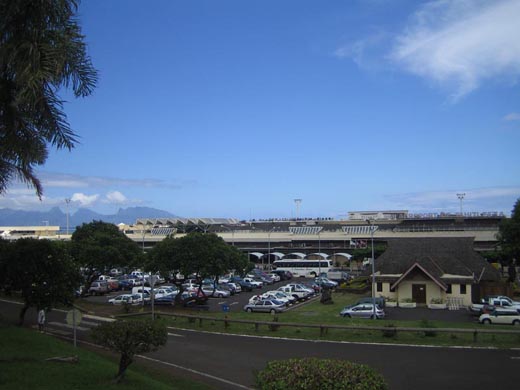
Faa'a International Airport or Tahiti Faa'a International Airport (French: Aéroport International Tahiti Faa'a) (IATA: PPT, ICAO: NTAA) is located in the commune (municipality) of Faa'a, on the island of Tahiti, French Polynesia, 5 km (3.1 mi) west southwest from the town center of Papeete, the capital of French Polynesia. It is the only airport in French Polynesia serving international flights.
Because of limited level terrain, rather than leveling large stretches of sloping agricultural land, the airport is built primarily on reclaimed land on the coral reef just off-shore. The airport, operated by Setil Aéroports, has a single 3,420 m (11,220 ft) runway, large and sound enough to accommodate all commercial and military aircraft. Airlines and destinations
| Airlines |
Destinations |
| Aircalin |
Nouméa |
| Air France |
Los Angeles |
| Air Moorea |
Moorea |
| Air New Zealand |
Auckland |
| Air Tahiti |
Ahe, Atuona, Arutua, Bora Bora, Fakarava, Gambier, Hao, Huahine, Kaukura, Manihi, Maupiti, Makemo, Moorea, Matavia, Nuku Hiva, Raiatea, Rangiroa, Rarotonga, Rimatara, Rurutu, Raivavae, Tikehau, Takapoto, Takaroa, Tubuai, Ua Huka, Ua Pou |
| Air Tahiti Nui |
Auckland, Los Angeles, Paris-Charles de Gaulle, Sydney [seasonal], Tokyo-Narita |
| Hawaiian Airlines |
Honolulu |
| LAN Airlines |
Hanga Roa, Santiago de Chile |
Incidents
 | |
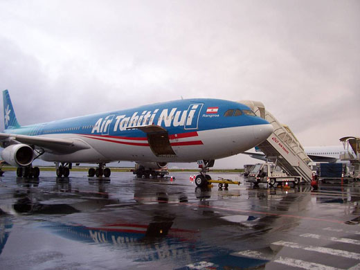
Air Tahiti Nui Airbus A340 at the airport |
- On 13 July 1973, Pan Am Flight 816, a Boeing 707, crashed into the sea just after take-off. 72 of the 73 on board were killed.
- On 12 September 1993, Air France flight 72, a 747-428, ran off the runway on landing, running into the reef at the end of the tarmac. The nose of the 747 was submerged in the water. There were no fatalities.
- On 24 December 2000, Hawaiian Airlines flight 481, a DC-10-10, overshot the runway landing and slid off the tarmac during a bad storm. There was one minor injury and no fatalities.
The above content comes from Wikipedia and is published under free licenses – click here to read more.
| General Info
|
| Country |
French Polynesia
|
| ICAO ID |
NTAA
|
| Time |
UTC-10
|
| Latitude |
-17.553750
17° 33' 13.50" S
|
| Longitude |
-149.607236
149° 36' 26.05" W
|
| Elevation |
5 feet
2 meters
|
| Type |
Civil
|
| Magnetic Variation |
012° E (01/06)
|
| Operating Agency |
CIVIL GOVERNMENT, (LANDING FEES AND DIPLOMATIC CLEARANCE MAY BE REQUIRED)
|
| Island Group |
Society I
|
| Operating Hours |
24 HOUR OPERATIONS
|
| International Clearance Status |
Airport of Entry
|
| Communications
|
| TWR |
118.1
|
| GND |
121.9
|
| ATIS |
128.8
|
| APP |
118.1
121.3
|
| Communications Remarks |
|
| TWR |
ATS C (689)86-1150 or (689)86-1151.
|
| Runways
|
| ID |
Dimensions |
Surface |
PCN |
ILS
|
| 04/22 |
11360 x 148 feet
3463 x 45 meters |
ASPHALT |
053FAWU |
YES
|
| Navaids
|
| Type |
ID |
Name |
Channel |
Freq |
Distance From Field |
Bearing From Navaid
|
| VOR-DME |
TAF |
TAHITI FAAA |
076X |
112.9 |
At Field |
-
|
| NDB |
MO |
MOOREA |
- |
377.5 |
9.9 NM |
102.6
|
| Supplies/Equipment
|
| Fuel |
115/145 octane gasoline, leaded, MIL-L-5572F (PURPLE)
100/130 octane gasoline, leaded, MIL-L-5572F (GREEN)
|
| Oil |
O-123, 1065,(Dispersant)Reciprocating Engine Oil(MIL L 22851 Type III)
O-128, 1100,(Dispersant)Reciprocating Engine Oil(MIL L 22851 Type II)
O-132, 1005, Jet Engine Oil (MIL L 6081)
O-133, 1010, jet Engine Oil (MIL l 6081)
O-148, MIL L 7808 (Synthetic Base), Turboprop/Turboshaft Engine
|
| Remarks
|
| CAUTION |
BASH. Partial absence of Rwy shoulder NW thld of Rwy 22. Canal parl to left of Rwy 22 to parking area.
|
| FUEL |
SOMSTAT BP 60 Faa'a C (689)80-3235 or (689)86-3425 (100, A1).
|
| LGT |
PAPI Rwy 04 MEHT 75'; Rwy 22 MEHT 80'. Rwy edge lgt on ldg are yellow last 1969'.
|
| OIL |
O-123-128-132-133-148
|
| OPR HOURS |
H24
|
| RSTD |
Loop twy at Rwy 22 clsd.
|
| TFC PAT |
Rwy 22 rgt hand tfc.
|
The content above was published at Airports-Worldwide.com in 2020.
We don't guarantee the information is fresh and accurate. The data may be wrong or outdated.
For more up-to-date information please refer to other sources.
|
 |


