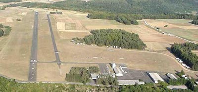
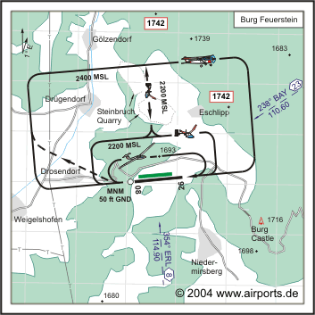
 |
|

ICAO Code EDQE
Name BURG FEUERSTEIN
Land Deutschland
Bundesland Bayern
Letzte Änderung 8. Dezember 2004
Kategorie Verkehrslandeplatz / Public Airfield
Betreiber / Operator Fränkische Fliegerschule Feuerstein e.V.

Lage / Location 2.2 NM NW Ebermannstadt
LFZ / ACFT Bis / up to 2000 kg, 5700 kg PPR, HEL 5700 kg
Helicopter Ja / Yes
Motorsegler / GLDP Ja / Yes
Segelflugzeuge / GLD Ja / Yes
Ballone Ja / Yes
UL Ja / Yes
Fallschirmspringen / PJE Ja / Yes
Summer 0800 - 1600/SS
Winter bis/to 30. 11. und/and ab/from 01.02. Mon-Fri 0800 - 1600/SS
O/T PPR
Einschränkungen siehe AIP AD 1-6/restrictions see AIP AD 1-6
Luftaufsicht / OPS +49 (0)9194 / 797577
PPR +49 (0)9194 / 797575
AIS AIS-Centre EDDZ, +49 (0)69 / 78072500
APP EDDN +49 (0)89 / 9780330
MET (0190)077225
Gafor 56
Zoll / Customs Nein / No
Fuel 100 LL, Super bleifrei
Oil SAE 15W50, D100
Hangar Nein / No
Höhe / Elevation 1674 ft / 510 m
FIS Langen Information 127.975
Frequenz Tower 130.775 EN / GE
NAV Aids 354°/8 NM from ERL VOR/DME 114.90/Ch 96 238°/23 NM from
BAY VOR 110.60
Koordinaten 49 47, 63 N / 11 07, 99 E
Platzrunde / Traffic circuit N 2400
Landebahnen / RWY 2
RWY 973 x 15 m, ASPHALT
RWY 08 TKOF 973 m; LDG 863 m
RWY 26 TKOF 863 m; LDG 973 m
MTOW 2000 kg, PPR 5700 kg,
RWY II 650 x 30 m, Gras
RWY 08 TKOF 650 m; LDG 625 m
RWY 26 TKOF 650 m; LDG 650 m
MTOW RWY II 2000 kg, PPR Heli 5700 kg
Bemerkungen / Remarks Starker GLD- Betrieb + PJE! UL acft PPR! Bei E-Wind
starke Abwinde im Anflug auf RWY 09! Wohngebiete meiden!
Restaurant - Yes
Adresse
Flugplatz
ZIP / City D-91320 Ebermannstadt
Tel. 09194 - 79 75 75
Fax 09194 - 79 75 76
E-Mail: info at fffeuerstein de
WWW: http://www.fffeuerstein.de/
Images and information placed above are from
http://www.fffeuerstein.de/
http://www.airports.de/airport.php?ICAO=EDQE
We thank them for the data!
| General Info
|
| Country |
Germany
|
| ICAO ID |
EDQE
|
| Time |
UTC+1(+2DT)
|
| Latitude |
49.793833
49° 47' 37.80" N
|
| Longitude |
11.133167
011° 07' 59.40" E
|
| Elevation |
1674 feet
510 meters
|
| Magnetic Variation |
001° E (01/05)
|
| Operating Agency |
CIVIL GOVERNMENT, (LANDING FEES AND DIPLOMATIC CLEARANCE MAY BE REQUIRED)
|
| Operating Hours |
NO OPERATING HOURS LISTED
|
| Daylight Savings Time |
Last Sunday in March to last Sunday in October
|
| Communications
|
| LANGEN INFO |
127.975
|
| FEUERSTEIN INFO |
130.775
|
| Runways
|
| ID |
Dimensions |
Surface |
PCN |
ILS
|
| 08/26 |
3190 x 49 feet
972 x 15 meters |
ASPHALT |
- |
NO
|
| 08L/26R |
2317 x 85 feet
706 x 26 meters |
GRASS OR EARTH NOT GRADED OR ROLLED. |
- |
NO
|
| Supplies/Equipment
|
| Fuel |
100/130 MIL Spec, low lead, aviation gasoline (BLUE)
|
| Remarks
|
| CAUTION |
Gldr act.
|
| FUEL |
(NC-100LL)
|
| NS ABTMT |
Before 0600Z++, btn 1200-1400Z++, aft SS Mon-Fri. Before 0800Z++ and aft 1200Z++Sat, Sun, hol.
|
| OPR HOURS |
Opr 0800-1600Z++ -SS, O/T PPR.
|
Runway 08/26
3190 x 49 feet
972 x 15 meters
| Runway 08
|
| Surface |
ASPHALT
|
| True Heading |
088.0
|
| Latitude |
49.793422
49° 47' 36.32" N
|
| Longitude |
11.125669
011° 07' 32.41" E
|
| Elevation |
1633.0 feet
498 meters
|
| Slope |
1.2°
|
| Landing Distance |
2895 feet
882 meters
|
| Takeoff Distance |
3190 feet
972 meters
|
| Displaced Threshold Length |
295 feet
90 meters
|
| Runway 26
|
| Surface |
ASPHALT
|
| True Heading |
268.0
|
| Latitude |
49.793742
49° 47' 37.47" N
|
| Longitude |
11.139164
011° 08' 20.99" E
|
| Elevation |
1670.0 feet
509 meters
|
| Slope |
-1.2°
|
| Landing Distance |
3190 feet
972 meters
|
| Takeoff Distance |
3190 feet
972 meters
|
Runway 08L/26R
2317 x 85 feet
706 x 26 meters
| Runway 08L
|
| Surface |
GRASS OR EARTH NOT GRADED OR ROLLED.
|
| True Heading |
087.0
|
| Latitude |
49.794264
49° 47' 39.35" N
|
| Longitude |
11.128256
011° 07' 41.72" E
|
| Landing Distance |
2317 feet
706 meters
|
| Takeoff Distance |
2317 feet
706 meters
|
| Runway 26R
|
| Surface |
GRASS OR EARTH NOT GRADED OR ROLLED.
|
| True Heading |
267.0
|
| Latitude |
49.794628
49° 47' 40.66" N
|
| Longitude |
11.138047
011° 08' 16.97" E
|
| Landing Distance |
2317 feet
706 meters
|
| Takeoff Distance |
2317 feet
706 meters
|
The content above was published at Airports-Worldwide.com in 2005.
We don't guarantee the information is fresh and accurate. The data may be wrong or outdated.
For more up-to-date information please refer to other sources.
|
 |


