 |
|
Etwa 10 km südlich vom Flugplatz befindet sich der Dümmer See.
Der Dümmer ist mit einer Wasserfläche von 16 km² der zweitgrößte
Binnensee Norddeutschlands. Jeder, der nicht nur am Strand liegen möchte,
wird hier viele Möglichkeiten der Freizeitgestaltung vorfinden. Für
Naturfreunde hat der Dümmer See mit seinen angrenzenden Naturschutzgebieten
viel zu bieten.
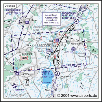
ICAO Code ETND
Name DIEPHOLZ
Land Deutschland
Bundesland Niedersachsen
Letzte Änderung 12. November 2003
Kategorie Militärflugplatz und Verkehrslandeplatz
Betreiber / Operator Bundeswehr-Flugplatz Diepholz Betr. GmbH & co.
KG
Lage / Location 1,5 NM SW Diepholz
Nachtflug / NVFR NVFR
LFZ / ACFT Bis / up to 2000 kg
Helicopter Ja / Yes
Motorsegler / GLDP Ja / Yes
UL Ja / Yes
Fallschirmspringen / PJE Ja / Yes
Luftschiffe/Airships - andere Luftfahrzeuge/other aircraft PPR
Summer SAT, SUN, HOL 0700-SS+30/1800, O/T PPR
Winter SAT, SUN, HOL 0800-SS+30, O7T PPR
CTR MON-FRI, EXC HOL PPR
Luftaufsicht / OPS +49 (0)5441 / 4426, 927400, Fax 4425
AIS AIS-Centre EDDZ +49 (0)69 / 78072500
MET (0190) 077221
Gafor 7
Zoll / Customs PPR 24HR
Fuel Jet A1, Avgas, Mogas
Oil 15W50
Hangar Nein / No
Höhe / Elevation 127 ft / 39 m
FIS Bremen Information 119.825
Rufzeichen / Call sign Diepholz Tower/Turm
Frequenz Tower 122.100 EN / GE, zu anderen Zeiten/ other times Diepholz
Info 122.600 GE
NAV Aids 006°/23 NM from OSN 114.30 - 268°/38 NM from NIE 116.50
Koordinaten 52 35, 13 N / 08 20, 44 E
Platzrunde / Traffic circuit S 1000
Landebahnen / RWY 1
RWY 1283 x 45 m, ASPHALT
RWY 08 TKOF 1283 m; LDG 1283 m
RWY 26 TKOF 1283 m; LDG 1283 m
MTOW 2000 kg, PPR LCN 120
Bemerkungen / Remarks SAT, SUN, HOL GLD im Nordbereich. Wohngebiete meiden
Beschränkungen / Restrictions Während der mil. Betriebszeiten
(HX) ist bei IMC vorher PPR einzuholen.
Restaurant Yes
Adresse
Lehmder Damm 3
ZIP / City D-49356 Diepholz
Fon +49 (0)5441 / 4426, 927400
Fax 4425
e-Mail: fdd at flugplatz-diepholz de
WWW: http://www.flugplatz-diepholz.de/
Images and information placed above are from
http://www.airports.de/airport.php?ICAO=ETND
http://www.mil-airfields.de/de/list_D.htm
We thank them for the data!
| General Info
|
| Country |
Germany
|
| ICAO ID |
ETND
|
| Time |
UTC+1(+2DT)
|
| Latitude |
52.585500
52° 35' 07.80" N
|
| Longitude |
8.340667
008° 20' 26.40" E
|
| Elevation |
127 feet
39 meters
|
| Type |
Joint (Civil and Military)
|
| Magnetic Variation |
000° E (01/05)
|
| Beacon |
Yes
|
| Operating Agency |
MILITARY - CIVIL JOINT USE AIRPORT
|
| Operating Hours |
SEE REMARKS FOR OPERATING HOURS OR COMMUNICATIONS FOR POSSIBLE HOURS
|
| International Clearance Status |
Airport of Entry
|
| Daylight Savings Time |
Last Sunday in March to last Sunday in October
|
| Communications
|
| TWR |
140.6
122.1
251.5
257.8
|
| BREMEN RADAR |
124.65
290.6
|
| INFO |
122.6
|
| BREMEN INFO |
119.825
385.2
|
| Runways
|
ID
|
Dimensions |
Surface |
PCN |
ILS
|
| 08/26 |
4209 x 148 feet
1283 x 45 meters |
ASPHALT |
- |
YES
|
| Navaids
|
| Type |
ID |
Name |
Channel |
Freq |
Distance From Field |
Bearing From Navaid
|
| NDB |
DP |
DIEPHOLZ |
- |
325 |
4.1 NM |
264.5
|
| Supplies/Equipment
|
| Fuel |
JP-8, SemiKeroscene MIL Spec T-83133, without icing inhibitor
|
| Oil |
O-133, 1010, jet Engine Oil (MIL l 6081)
O-156, MIL L 23699 (Synthetic Base)Turboprop/Turboshaft Engine
|
| Remarks
|
| CAUTION |
Hvy stu trng dur opr hr wi 10 NM rad of arpt to 3000'. Ant mast 242' MSL/119' AGL, 344 (T) 1837' fr thld Rwy 26, day and ngt mrk. Two ant mast 216' MSL/93' AGL, 309 (T) 1690' fr thld Rwy 26, day and ngt mrk. Chimney 239' MSL/116' AGL, 317(T) 2215' fr thld Rwy 26, day and ngt mrk.
|
| CSTMS/AG/IMG |
PPR 24 hr. No cargo.
|
| FUEL |
J8
|
| MISC |
If destn of acft is LW WERFT 23 this shall be inserted in item 18 of the FPL as follows: LW WERFT 23. Fone C05441-5900-2265.
|
| OIL |
O-133-156
|
| RSTD |
PPR 24 hr.
|
| TRAN ALERT |
No cross svc exc reful.
|
Runway 08/26
4209 x 148 feet
1283 x 45 meters
| Runway 08
|
| Surface |
ASPHALT
|
| True Heading |
085.0
|
| Latitude |
52.584956
52° 35' 05.84" N
|
| Longitude |
8.331333
008° 19' 52.80" E
|
| Elevation |
127.0 feet
39 meters
|
| Slope |
-0.1°
|
| Landing Distance |
4209 feet
1283 meters
|
| Takeoff Distance |
4209 feet
1283 meters
|
| Lighting System |
HIRL
|
| Runway 26
|
| Surface |
ASPHALT
|
| True Heading |
265.0
|
| Latitude |
52.586044
52° 35' 09.76" N
|
| Longitude |
8.350089
008° 21' 00.32" E
|
| Elevation |
124.0 feet
38 meters
|
| Slope |
0.1°
|
| Landing Distance |
4209 feet
1283 meters
|
| Takeoff Distance |
4209 feet
1283 meters
|
| Lighting System |
HIRL
J |
The content above was published at Airports-Worldwide.com in 2005.
We don't guarantee the information is fresh and accurate. The data may be wrong or outdated.
For more up-to-date information please refer to other sources.
|
|


