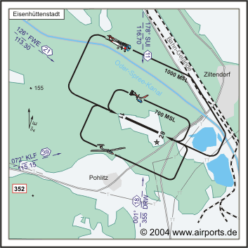
Eisenhuttenstadt Airfield |
ICAO Code EDAE
Name EISENHÜTTENSTADT
Land Deutschland
Bundesland Brandenburg
Letzte Änderung 15. September 2004
Kategorie Verkehrslandeplatz / Public Airfield
Betreiber / Operator Flugplatzgesellschaft Eisenhüttenstadt/Frankfurt
(Oder) mbH
Lage / Location 3.2 NM NNW Eisenhüttenstadt, 8.1 NM S Frankfurt/Oder
Nachtflug / NVFR NVFR
LFZ / ACFT Bis / up to 8000 kg
Helicopter Ja / Yes
Motorsegler / GLDP Ja / Yes
Segelflugzeuge / GLD Ja / Yes
Ballone Ja / Yes
Luftsportgeräte/Flying sports products, Flugmodelle/flying models
Summer 0700-1700
Winter 0800-1800
Luftaufsicht / OPS +49 (0)33653 / 5567, +49 (0)172 / 3286391, Fax 46514
AIS EDDB +49 (0)30 / 60918250
MET (0190) 077222
Gafor 19
Zoll / Customs JA/YES
Fuel 100 LL
Oil Nein / No
Hangar Ja / Yes
Höhe / Elevation 149 ft / 44 m
FIS Berlin Information 126.350
VDF / QDM 122.000
Rufzeichen / Call sign Eisenhüttenstadt Info
Frequenz Tower 122.000 GE
NAV Aids ABN 126°/22 NM from FWE VOR/DME 113.30/Ch 80 073°/39
NM from KLF VOR/DME 115.15/Ch 98y - 179°/11 NM from SUI 116.70 -
Koordinaten 52 11, 84 N / 14 35, 14 E
Platzrunde / Traffic circuit NE 1000
Landebahnen / RWY 1
RWY 1170 x 23 m, ASPHALT
RWY 11 TKOF 1170 m; LDG 1170 m
RWY 29 TKOF 1170 m; LDG 1170 m
MTOW 8000 kg
Bemerkungen / Remarks GLD + PJE! UL-Betrieb!
Restaurant - Yes
Adresse
Dorfstr. 45 a
ZIP / City D-15890 Pohlitz
Fon +49 (0)33653 / 465145
Fax 46514
WWW:
http://www.airports.de/airport.php?ICAO=EDAE
Images and information placed above are from
http://www.airports.de/airport.php?ICAO=EDAE
We thank them for the data!
| General Info
|
| Country |
Germany
|
| ICAO ID |
EDAE
|
| Time |
UTC+1(+2DT)
|
| Latitude |
52.197333
52° 11' 50.40" N
|
| Longitude |
14.585667
014° 35' 08.40" E
|
| Elevation |
149 feet
45 meters
|
| Magnetic Variation |
002° E (01/05)
|
| Beacon |
Yes
|
| Operating Agency |
CIVIL GOVERNMENT, (LANDING FEES AND DIPLOMATIC CLEARANCE MAY BE REQUIRED)
|
| Operating Hours |
SEE REMARKS FOR OPERATING HOURS OR COMMUNICATIONS FOR POSSIBLE HOURS
|
| Daylight Savings Time |
Last Sunday in March to last Sunday in October
|
| Communications
|
| INFO |
122.0
|
| BERLIN INFO |
126.35
|
| Runways
|
ID
|
Dimensions |
Surface |
PCN |
ILS
|
| 11/29 |
3839 x 75 feet
1170 x 23 meters |
ASPHALT |
- |
NO
|
| Supplies/Equipment
|
| Fuel |
100/130 MIL Spec, low lead, aviation gasoline (BLUE)
|
| Remarks
|
| CSTMS/IMG |
CSTMS avbl.
|
| FUEL |
(NC-100LL)
|
| OPR HOURS |
Opr 0800Z-SS+30, OT O/R (0700-1700Z, OT O/R DT).
|
Runway 11/29
3839 x 75 feet
1170 x 23 meters
| Runway 11
|
| Surface |
ASPHALT
|
| True Heading |
114.0
|
| Latitude |
52.199472
52° 11' 58.10" N
|
| Longitude |
14.577850
014° 34' 40.26" E
|
| Landing Distance |
3839 feet
1170 meters
|
| Takeoff Distance |
3839 feet
1170 meters
|
| Lighting System |
LIRL
BF |
| Runway 29
|
| Surface |
ASPHALT
|
| True Heading |
294.0
|
| Latitude |
52.195194
52° 11' 42.70" N
|
| Longitude |
14.593483
014° 35' 36.54" E
|
| Landing Distance |
3675 feet
1120 meters
|
| Takeoff Distance |
3839 feet
1170 meters
|
| Displaced Threshold Length |
164 feet
50 meters
|
| Lighting System |
LIRL
BF
PAPI |
The content above was published at Airports-Worldwide.com in 2005.
We don't guarantee the information is fresh and accurate. The data may be wrong or outdated.
For more up-to-date information please refer to other sources.
|


