 |
|
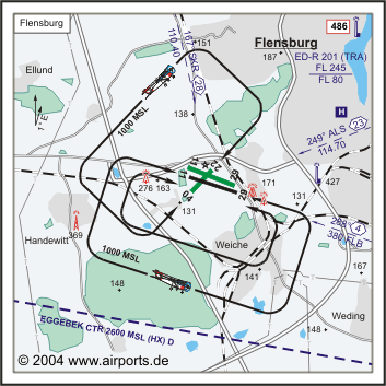
Flensburg Schäferhaus Airfield |

ICAO Code EDXF
Name FLENSBURG - Schäferhaus
Land Deutschland
Bundesland Schleswig-Holstein
Letzte Änderung 15. September 2004
Kategorie Verkehrslandeplatz / Public Airfield
Betreiber / Operator Flensburger Flughafen-Betriebsgesellschaft mbH
Lage / Location 1.6 NM SW Flensburg
Nachtflug / NVFR NVFR
LFZ / ACFT Bis / up to 30000 kg
Helicopter Ja / Yes
Motorsegler / GLDP Ja / Yes
Segelflugzeuge / GLD Ja / Yes
UL Ja / Yes
Fallschirmspringen / PJE Ja / Yes
UL mit Funksprechausrüstung/with radiotelephony equipment
Summer 0700-SS+30/1800
Winter 0800-SS+30/1900
O/T PPR
15 MAR-30 SEP 1200-1400 (1100-1300) Starts nur für Streckenflüge
zulässig/take offs only permitted for enroute flights. Die Sonderregelung
für die Übermittlung von Flugplänen ist zu beachten (ENR
1-35)./The special regulation for filing flight plans has to be observed
(ENR 1-35).
Luftaufsicht / OPS +49 (0)461 / 91700, Fax 95346, Außerhalb der
Betriebszeiten/outside operating hours +49 (0)461 / 32965, +49 (0)4625
/ 7930, 0171 / 3186101, +49 (0)4626 / 620
PPR +49 (0)461 / 32965, 97399, 92492, +49 (0)4626 / 620
AIS AIS-Centre EDDZ +49 (0)69 / 78072500
ACC EDDW +49 (0)421 / 5372120
MET (0190) 077221
Gafor 4
 Zoll / Customs 0800-2300 (0700-2200), O / R 1 HR, Für Ausflüge
keine Voranmeldung erforderlich/For exits no prior request required
Zoll / Customs Fon +49 (0)461 / 91700
Fuel 100 LL, Jet A1
Oil 80, 100, D 80, D 100, 20W50
Hangar Ja / Yes
Höhe / Elevation 130 ft / 40 m
FIS Bremen Information 125.100
VDF / QDM 122.850
Rufzeichen / Call sign Flensburg Info
Frequenz Tower 122.850 En/Ge
NAV Aids ABNVASIS NDB/L FLB 380 290°/4 NM TO RWY 29 250°/23 NM
from ALS VOR 114.70 169°/28 NM from SKR VOR 110.40
Koordinaten 54 46, 40 N / 09 22, 73 E
Platzrunde / Traffic circuit S 1000
Landebahnen / RWY 3
RWY 1220 x 30 m, ASPHALT
RWY 11 TKOF 1040 m; LDG 1220 m
RWY 29 TKOF 1220 m; LDG 1040 m
MTOW 30000 kg
RWY II 1200 x 60 m, Gras
RWY 11 TKOF 900 m; LDG 900 m
RWY 29 TKOF 900 m; LDG 900 m
MTOW RWY II 5700 kg
RWY III 700 x 45 m, GRAS
RWY 04 TKOF 700 m; LDG 615 m
RWY 22 TKOF 615 m; LDG 700 m
MTOW RWY III 5700 kg
Bemerkungen / Remarks Eggebek CTR (2600 MSL, HX) S des Platzes! Wohngebiete
meiden! PJE + GLD! UL-Betrieb mit Funk!
Restaurant - Yes
Adresse
Lecker Chaussee 127
ZIP / City D-24941 Flensburg
Fon +49 (0)461 / 91700
E-Mail: redaktion at flensburg-online
de
WWW: http://www.flensburg-online.de/flugplatz/
Images and information placed
above are from
http://www.airports.de/airport.php?ICAO=EDXF
We thank them for the data!
| General Info
|
| Country |
Germany
|
| ICAO ID |
EDXF
|
| Time |
UTC+1(+2DT)
|
| Latitude |
54.771772
54° 46' 18.38" N
|
| Longitude |
9.378214
009° 22' 41.57" E
|
| Elevation |
130 feet
40 meters
|
| Magnetic Variation |
000° E (01/05)
|
| Beacon |
Yes
|
| Operating Agency |
CIVIL GOVERNMENT, (LANDING FEES AND DIPLOMATIC CLEARANCE MAY BE REQUIRED)
|
| Operating Hours |
SEE REMARKS FOR OPERATING HOURS OR COMMUNICATIONS FOR POSSIBLE HOURS
|
| Daylight Savings Time |
Last Sunday in March to last Sunday in October
|
| Communications
|
| INFO |
122.85
|
| BREMEN INFO |
125.1
|
| Runways
|
ID
|
Dimensions |
Surface |
PCN |
ILS
|
| 04/22 |
2297 x 148 feet
700 x 45 meters |
GRASS OR EARTH NOT GRADED OR ROLLED. |
- |
NO
|
| 11/29 |
4003 x 98 feet
1220 x 30 meters |
ASPHALT |
- |
NO
|
| 11L/29R |
3937 x 197 feet
1200 x 60 meters |
GRASS OR EARTH NOT GRADED OR ROLLED. |
- |
NO
|
| Supplies/Equipment
|
| Fuel |
Jet A1, without icing nhibitor.
100/130 MIL Spec, low lead, aviation gasoline (BLUE)
|
| Remarks
|
| CSTMS/AG/IMG |
O/R 1 hr 0800-2300Z++. For exits no prior req rqrd.
|
| FUEL |
(NC-100LL, A1)
|
| MISC |
Fone C0461-91700.
|
| OPR HOURS |
Opr 0800Z++-SS+30 or 1900Z++, OT PPR.
|
Runway 04/22
2297 x 148 feet
700 x 45 meters
| Runway 04
|
| Surface |
GRASS OR EARTH NOT GRADED OR ROLLED.
|
| True Heading |
043.0
|
| Latitude |
54.770625
54° 46' 14.25" N
|
| Longitude |
9.372211
009° 22' 19.96" E
|
| Landing Distance |
2018 feet
615 meters
|
| Takeoff Distance |
2297 feet
700 meters
|
| Displaced Threshold Length |
279 feet
85 meters
|
| Runway 22
|
| Surface |
GRASS OR EARTH NOT GRADED OR ROLLED.
|
| True Heading |
223.0
|
| Latitude |
54.775069
54° 46' 30.25" N
|
| Longitude |
9.379322
009° 22' 45.56" E
|
| Landing Distance |
2297 feet
700 meters
|
| Takeoff Distance |
2297 feet
700 meters
|
Runway 11/29
4003 x 98 feet
1220 x 30 meters
| Runway 11
|
| Surface |
ASPHALT
|
| True Heading |
108.0
|
| Latitude |
54.772836
54° 46' 22.21" N
|
| Longitude |
9.367931
009° 22' 04.55" E
|
| Landing Distance |
4003 feet
1220 meters
|
| Takeoff Distance |
4200 feet
1280 meters
|
| Overrun Length |
197 feet
60 meters
|
| Overrun Surface |
SURFACE UNKNOWN.
|
| Lighting System |
HIRL
V |
| Runway 29
|
| Surface |
ASPHALT
|
| True Heading |
288.0
|
| Latitude |
54.769397
54° 46' 09.83" N
|
| Longitude |
9.385931
009° 23' 09.35" E
|
| Landing Distance |
3412 feet
1040 meters
|
| Takeoff Distance |
4987 feet
1520 meters
|
| Displaced Threshold Length |
591 feet
180 meters
|
| Overrun Length |
984 feet
300 meters
|
| Overrun Surface |
SURFACE UNKNOWN.
|
| Lighting System |
SF
HIRL
BO
V |
Runway 11L/29R
3937 x 197 feet
1200 x 60 meters
| Runway 11L
|
| Surface |
GRASS OR EARTH NOT GRADED OR ROLLED.
|
| True Heading |
113.0
|
| Latitude |
54.775497
54° 46' 31.79" N
|
| Longitude |
9.370869
009° 22' 15.13" E
|
| Landing Distance |
2953 feet
900 meters
|
| Takeoff Distance |
3937 feet
1200 meters
|
| Displaced Threshold Length |
984 feet
300 meters
|
| Runway 29R
|
| Surface |
GRASS OR EARTH NOT GRADED OR ROLLED.
|
| True Heading |
293.0
|
| Latitude |
54.771333
54° 46' 16.80" N
|
| Longitude |
9.388069
009° 23' 17.05" E
|
| Landing Distance |
2953 feet
900 meters
|
| Takeoff Distance |
3937 feet
1200 meters
|
| Displaced Threshold Length |
984 feet
300 meters
|
The content above was published at Airports-Worldwide.com in 2005.
We don't guarantee the information is fresh and accurate. The data may be wrong or outdated.
For more up-to-date information please refer to other sources.
|
 |


