 |
|
 The
new Hamburg Airport The
new Hamburg Airport
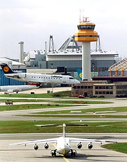
Hamburg Airport is a modern, customer-oriented service company. The
opening of the new Terminal 1 in May 2005 is a further important milestone
in the HAM 21 Extension Project. The completion of this spectacular project
will mark the end of Hamburg Airport¦s transition from metropolitan
hub to one of Europe¦s most convenient and appealing airports.
New access roads, more parking spaces and the unique metropolitan location
give air passengers from all over north Germany an unparalleled level
of service and outstanding convenience. With around 10 million passengers
every year Hamburg Airport is Germany¦s fifth-largest airport.
Key economic engine for the region
Hamburg Airport is a key feature of the economy in the greater Hamburg
region. The companies based at the Airport employ more than 13,000 people
and generate €1.5 billion every year. These companies play a decisive
role in driving the growth of the aviation industry in Hamburg and helping
the city to remain one of the world¦s top three aviation locations.
Gateway into the world
An attractive network of services makes Hamburg Airport the ideal starting
point for any trip. Mallorca, London, Riga, New York (from June 2005)
and Dubai (from October 2005), scheduled flights, charter services and
low cost airlines v Hamburg Airport offers a wide array of services and
destinations all around the world to meet the travel needs of all air
passengers.
Complete commitment to environmental protection
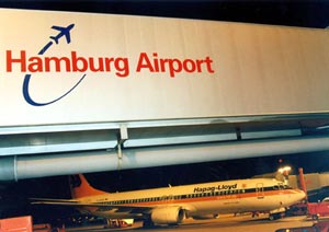
Hamburg Airport takes environmental protection very seriously. The noise
protection hangar, the only one of its kind in the world, is only one
of many examples that show how Hamburg Airport solves the environmental
responsibilities associated with being a metropolitan airport. Noise protection
schemes for local residents and complete information transparency underscore
the Airport¦s commitment to being a good neighbour.
Public-private partnership
Hamburg Airport is an excellent example for a highly successful public-private
partnership. The Airport¦s shareholders are the City of Hamburg
(51%) and HAP Hamburg Airport Partners GmbH & Co. KG (Hochtief Airport
GmbH and Aer Rianta International) 49%.
 ICAO Code EDDH
IATA Code HAM
Name HAMBURG
Land Deutschland
Bundesland Hamburg
Letzte Änderung 12. November 2003
Kategorie Int. Verkehrsflughafen / Int. Airport
Betreiber / Operator Flughafen Hamburg GmbH
Lage / Location 4.6 NM N Stadtmitte/Centre of Hamburg
Nachtflug / NVFR NVFR
Instrumentenflug / IFR IFR
LFZ / ACFT Bis / up to PCN 65 F/A/W/T
Helicopter Ja / Yes
Einschränkungen siehe Kartenteil/ restrictions see chart section
Summer H 24
Winter H 24
Nachtflugbeschränkung/Night flying restrictions 2100-0400 (2200-0500),
Tanken/Refueling 0400-2000 (0500-2100)
Luftaufsicht / OPS +49 (0)40 / 50752599, 50752600, Fax 50753359
AIS AIS-Centre +49 (0)69 / 78072500
Tower Turm +49 (0)40 / 596564, 50752381
MET (0190) 077221
Gafor 3
 Zoll / Customs H 24
Fuel 100 LL, Jet A1
Oil 80, 100, D 80, D 100, Turbo: ETO 274, ETO 2380, ETO 2389, ETO 25,
ETO 85, JET A2, JET 254
Hangar O / R
Höhe / Elevation 53 ft / 16 m
FIS Bremen Information 125.100
VDF / QDM O/R
Rufzeichen / Call sign Hamburg Tower/Turm
Frequenz Tower 121.275 EN/GE 126.850 EN/GE
Frequenz Ground 121.800 EN/GE
NAV Aids ABN PAPI DME ALF 115.80 am Platz/at field ILS RWY 23 111.50 ILS
15 111.10 ILS RWY 05 110.50
Koordinaten 53 37, 82 N / 09 59, 29 E
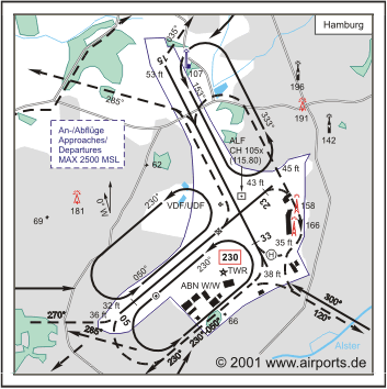
Landebahnen / RWY 2
RWY 3250 x 45,8 m, ASPHALT / CONCRETE
RWY 05 TKOF 3250 m; LDG 2952 m
RWY 23 TKOF 3250 m; LDG 3094 m
MTOW 65 F/A/W/T
RWY II 3666 x 45,8 m, ASPHALT / CONCRETE
RWY 15 TKOF 3666 m; LDG 3666 m
RWY 33 TKOF 3666 m; LDG 3220 m
MTOW RWY II 65 F/A/W/T
Restaurant - Yes
Address:
Flughafen Hamburg GmbH
Flughafenstr. 1-3
22335 Hamburg
T +49 (0) 40 / 50 75 v 0
F +49 (0) 40 / 50 75 v 12 34
E-mail: FHG at ham airport de
WWW: Hamburg Airport
Images and information placed
above are from
http://www.airport.de/
http://www.airports.de/airport.php?ICAO=EDDH
We thank them for the data!
| General Info
|
| Country |
Germany
|
| ICAO ID |
EDDH
|
| Time |
UTC+1(+2DT)
|
| Latitude |
53.630389
53° 37' 49.40" N
|
| Longitude |
9.988228
009° 59' 17.62" E
|
| Elevation |
53 feet
16 meters
|
| Type |
Civil
|
| Magnetic Variation |
001° E (01/05)
|
| Beacon |
Yes
|
| Operating Agency |
CIVIL GOVERNMENT, (LANDING FEES AND DIPLOMATIC CLEARANCE MAY BE REQUIRED)
|
| Alternate Name |
FUHLSBUTTEL
|
| International Clearance Status |
Airport of Entry
|
| Daylight Savings Time |
Last Sunday in March to last Sunday in October
|
| Communications
|
TWR
(121.275 Opr SR-SS, OT O/R.)
|
126.85
372.65
|
| APRON |
121.7
121.75
(121.7 Apron 1)(121.75 Apron 2)
|
| BREMEN RADAR |
134.25
124.225
299.85
East Radar 2 and 3 of BREMEN ACC
|
| GND |
121.8
|
| DIRECTOR |
118.2
124.625
299.85
|
ATIS
Opr 0420-2200Z++
|
123.125
|
| Runways
|
ID
|
Dimensions |
Surface |
PCN |
ILS
|
| 05/23 |
10663 x 150 feet
3250 x 46 meters |
ASPHALT |
065FAWT |
YES
|
| 15/33 |
12028 x 150 feet
3666 x 46 meters |
ASPHALT |
065FAWT |
YES
|
| Navaids
|
| Type |
ID |
Name |
Channel |
Freq |
Distance From Field |
Bearing From Navaid
|
| VORTAC |
HAM |
HAMBURG |
078X |
113.1 |
8.4 NM |
246.1
|
| NDB |
HAM |
HAMBURG |
- |
339 |
4.4 NM |
229.9
|
| DME |
ALF |
ALSTER |
105X |
- |
At Field |
-
|
| Supplies/Equipment
|
| Fuel |
Jet A1, without icing nhibitor.
100/130 MIL Spec, low lead, aviation gasoline (BLUE)
|
| Remarks
|
| CAUTION |
Const on sfc of Rwy 15/33. Rstd and chg will occur by NOTAM.
|
| FUEL |
Avbl 0500-2200Z++ (NC-100LL, A1). OT 2hr O/R.
|
| LGT |
PAPI Rwy 05 MEHT 69', PAPI Rwy 23 MEHT 59', PAPI Rwy 15 MEHT 65', PAPI Rwy 33 MEHT 62'.
|
| MISC |
Fone C(040) 50-75-25-99.
|
| RSTD |
No tkof or ldg btn 2200-0500Z++ exc sked and reg non-sked acft with reg arr times before 2200Z++, if delays unavoidable ldg and tkof perms til 2300Z++. Tkof other acft til 2130Z++.
|
Runway 05/23
10663 x 150 feet
3250 x 46 meters
| Runway 05
|
| Surface |
ASPHALT
|
| True Heading |
050.0
|
| Latitude |
53.618269
53° 37' 05.77" N
|
| Longitude |
9.963706
009° 57' 49.34" E
|
| Elevation |
36.0 feet
11 meters
|
| Slope |
0.1°
|
| Landing Distance |
9685 feet
2952 meters
|
| Takeoff Distance |
10860 feet
3310 meters
|
| Displaced Threshold Length |
978 feet
298 meters
|
| Overrun Length |
197 feet
60 meters
|
| Overrun Surface |
CONCRETE.
|
| Lighting System |
SF
CL
HIRL
REIL
T
PAPI |
| Runway 23
|
| Surface |
ASPHALT
|
| True Heading |
230.0
|
| Latitude |
53.637078
53° 38' 13.48" N
|
| Longitude |
10.001772
010° 00' 06.38" E
|
| Elevation |
45.0 feet
14 meters
|
| Slope |
-0.1°
|
| Landing Distance |
10151 feet
3094 meters
|
| Takeoff Distance |
10860 feet
3310 meters
|
| Displaced Threshold Length |
512 feet
156 meters
|
| Overrun Length |
197 feet
60 meters
|
| Overrun Surface |
CONCRETE.
|
| Lighting System |
SF
TDZL
CL
HIRL
REIL
A2
PAPI |
Runway 15/33
12028 x 150 feet
3666 x 46 meters
| Runway 15
|
| Surface |
ASPHALT
|
| True Heading |
153.0
|
| Latitude |
53.654411
53° 39' 15.88" N
|
| Longitude |
9.975211
009° 58' 30.76" E
|
| Elevation |
53.0 feet
16 meters
|
| Slope |
-0.1°
|
| Landing Distance |
12028 feet
3666 meters
|
| Takeoff Distance |
12225 feet
3726 meters
|
| Overrun Length |
197 feet
60 meters
|
| Overrun Surface |
CONCRETE.
|
| Lighting System |
SF
CL
HIRL
REIL
T
PAPI |
| Runway 33
|
| Surface |
ASPHALT
|
| True Heading |
333.0
|
| Latitude |
53.625128
53° 37' 30.46" N
|
| Longitude |
10.000525
010° 00' 01.89" E
|
| Elevation |
38.0 feet
12 meters
|
| Slope |
0.1°
|
| Landing Distance |
10564 feet
3220 meters
|
| Takeoff Distance |
12225 feet
3726 meters
|
| Displaced Threshold Length |
1464 feet
446 meters
|
| Overrun Length |
197 feet
60 meters
|
| Overrun Surface |
CONCRETE.
|
| Lighting System |
SF
CL
HIRL
REIL
A1
PAPI |
Navaids
| HAMBURG
|
| Type |
ID |
Channel |
Freq |
Country |
State
|
| VORTAC |
HAM |
078X |
113.1 |
Germany |
-
|
| Latitude |
Longitude |
Airport
|
53.685575
53° 41' 08.07" N |
10.204997
010° 12' 17.99" E |
EDDH |
Navaids
| HAMBURG
|
| Type |
ID |
Channel |
Freq |
Country |
State
|
| NDB |
HAM |
- |
339 |
Germany |
-
|
| Latitude |
Longitude |
Airport
|
53.676972
53° 40' 37.10" N |
10.083203
010° 04' 59.53" E |
EDDH |
Navaids
| ALSTER
|
| Type |
ID |
Channel |
Freq |
Country |
State
|
| DME |
ALF |
105X |
- |
Germany |
-
|
| Latitude |
Longitude |
Airport
|
53.635306
53° 38' 07.10" N |
9.994139
009° 59' 38.90" E |
EDDH |
The content above was published at Airports-Worldwide.com in 2005.
We don't guarantee the information is fresh and accurate. The data may be wrong or outdated.
For more up-to-date information please refer to other sources.
|
 |


