 |
 |
|
||||
|
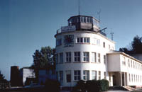
You’re coming to an enthusiastic community that supports approximately 13,000 Americans on 17 different installations. Hanau is located in the heart of Germany about 30 minutes from Frankfurt, which provides abundant travel and cultural opportunities. The local German cities are rich in history and offer many opportunities for recreation and excitement for the whole family to enjoy. Airport /Air Field Operations Mon-Fri 0900-1700 Phone CIV: (06183) 51-7564 Images and information placed above are from http://www.hanau.army.mil/ We thank them for the data!
Runway 05/238628 x 148 feet
|
||||||||||||||||||||||||||||||||||||||||||||||||||||||||||||||||||||||||||||||||||||||||||||||||||||||||||||||||||||||||||||||||||||||||||||||
| Runway 05 | |
|---|---|
| Surface | ASPHALT |
| True Heading | 052.0 |
| Latitude | 53.528564 53° 31' 42.83" N |
| Longitude | 9.821486 009° 49' 17.35" E |
| Elevation | 16.0 feet 5 meters |
| Slope | 0.0° |
| Landing Distance | 8287 feet 2526 meters |
| Takeoff Distance | 8628 feet 2630 meters |
| Displaced Threshold Length | 341 feet 104 meters |
| Lighting System | SF
CL LIRL REIL BO PAPI |
| Runway 23 | |
|---|---|
| Surface | ASPHALT |
| True Heading | 232.0 |
| Latitude | 53.543256 53° 32' 35.72" N |
| Longitude | 9.852656 009° 51' 09.56" E |
| Elevation | 15.0 feet 5 meters |
| Slope | 0.0° |
| Landing Distance | 6154 feet 1876 meters |
| Takeoff Distance | 8793 feet 2680 meters |
| Displaced Threshold Length | 2474 feet 754 meters |
| Overrun Length | 165 feet 50 meters |
| Overrun Surface | CONCRETE. |
| Lighting System | SF
CL HIRL REIL BO PAPI |
The content above was published at Airports-Worldwide.com in 2005.
We don't guarantee the information is fresh and accurate. The data may be wrong or outdated.
For more up-to-date information please refer to other sources.

 |
|
Copyright 2004-2026 © by Airports-Worldwide.com, Vyshenskoho st. 36, Lviv 79010, Ukraine Legal Disclaimer |
 The
mission of the U.S. Army Garrison Hessen is to provide equitable, effective
and efficient installation management support and services that enhance
the readiness and well-being of our mission commanders, Soldiers, civilians
and family members in a forward-deployed environment. USAG Hessen serves
the Baumholder, Büdingen, Butzbach, Dexheim, Friedberg, Gelnhausen,
Giessen, Hanau, Neubrücke, Strassburg, Wackernheim and Wiesbaden
military communities.
The
mission of the U.S. Army Garrison Hessen is to provide equitable, effective
and efficient installation management support and services that enhance
the readiness and well-being of our mission commanders, Soldiers, civilians
and family members in a forward-deployed environment. USAG Hessen serves
the Baumholder, Büdingen, Butzbach, Dexheim, Friedberg, Gelnhausen,
Giessen, Hanau, Neubrücke, Strassburg, Wackernheim and Wiesbaden
military communities.