 |
|
Unternehmensgrundsätze
Unternehmensgrundsätze der Flughafen Hannover-Langenhagen
GmbH
Wir entwickeln und betreiben unseren Flughafen wachstumsorientiert.
Wir handeln nach den Wünschen und Erwartungen unserer Kunden.
Wir nehmen die Herausforderungen des Marktes als Chance an.
Wir fördern und fordern unsere Mitarbeiterinnen und Mitarbeiter.
Wir begreifen Führung als Vorbildfunktion.
Wir führen unser Geschäft nach privatwirtschaftlichen Maßstäben.
Wir verstehen uns als Motor für die nachhaltige Entwicklung unserer
Region.
Wir übernehmen aktiv Verantwortung für unsere Umwelt.
Wir leben eine sich auf gegenseitiges Vertrauen und Akzeptanz gründende
Unternehmenskultur.
 Dates
and Facts Dates
and Facts
Geographical position of the airport:
52* 27' 42" North
09* 41' 05" East
Height above sea level: 53 m
Distance from Hannover City Centre: 11 km
Opening date:
April 1952
Operating times:
24 hours a day
Airport area:
2661 acres
Traffic connections:
Suburban Railway S5 will transport passengers from the central railway
station to the airport in only 12 minutes. Scheduled bus service No. 470
to Langenhagen connecting with the underground tramline No.1. Taxi stand
in front of the terminal. Direct transfer from your place of residence
to the airport and vice versa. Motorway access: via the A352 dual-carriageway
spur connecting the motorways A2/A7 Dortmund/Hamburg. After the year 2000
a rapid rail link (line S5) will be available directly to the main railway
station, extending to Hameln in the Hannover area rail network.
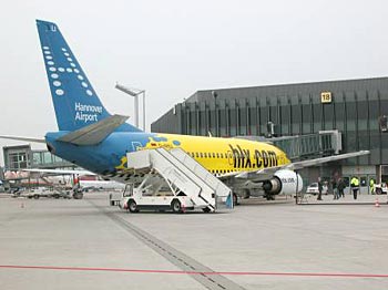
Passenger terminals:
Three compact triangular-shaped elements A, B, C with an effective working
area of about 75,000 m2. Horizontal separa-tion of the arrival and departure
levels, each with separate driveways. Connecting building between terminals
A and B as well as B and C with shopping arcade. Check-in: decentrally
in Halls A and B, centrally in Hall C. A total of 88 check-in desks, 20
passenger ramps, 3 departure bus gates. Capacity: up to 8 million passengers
per year. Underground railway station.
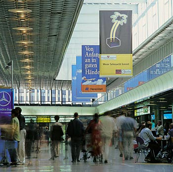
Service facilities for passengers and visitors
Restaurants, snack and expresso bars, retail shops, mini-market, duty
free shops, perfumery, leather wear goods, ties, exclusive writing utensils,
post office, bank, tour operators/last-minute, conference rooms, lounges,
observation terrace, children's play area, facilities for the disabled,
baby rooms, first-aid room, visitor service, airport service, lost property
office, baggage lockers, incoming service, tax-free refund, car rentals,
petrol station, airport hotels with congress and conference facilities.
Parking facilities:
A total of about 13,000 parking bays are available: 4285 in the near-terminal
multi-storey car parks P1, P2 and P3, 3750 bays in the three multi-storey
car parks 1, 2 , 3 located to the east as well 1450 bays in the multi-storey
car park located to the north. A further 2900 bays are available in the
open-air car park P10 as well as 480 short-term stay parking bays. A computer-controlled
parking guidance system is provided as an aid to orientation. Also available:
information parking bay, parking service as well as 50 exclusive parking
bays in a locked area with video surveillance.
Air freight facilities:
Cargo Centre capable of handling 60,000 tonnes yearly. Logistics, halls
and equipment for the handling and loading of special freight. Air freight
forwarders, customs. Automatic air freight handling procedure ALFA.
General Aviation:
Separate terminal (GAT 1) for private and business aircraft with all essential
check-in facilities - from the coffee bar to complete ground service.
Separate apron with parking positions for small aircraft.
Fire brigade:
In compliance with current ICAO standards the airport fire brigade has
all the necessary vehicles and equipment at its disposal and is ready
for action around the clock. A works fire brigade is available for fire-fighting
in airport buildings.
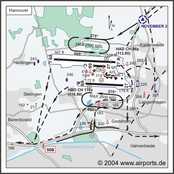
Take-off and landing runways:
The parallel runway system permits up to 50 aircraft movements per hour
in accordance with IFR. North runway, 3800 m long, 45 m wide, oriented
in the east-west direction (09L/27R). Instrument landing system (ILS)
for all-weather air traffic in accordance with traffic category CAT IIIb,
i.e. suitable for precision landing with horizontal visibility of only
50 m and vertical visibility of 0 m. High performance approach lighting
with approach flash; take-off lighting with threshold, centre-line, edge,
touchdown zone and end lighting; approach angle lighting (PAPI).
South runway, 2340 m long, 45 m wide, parallel to the north runway in
the east-west direction (O9L/27L). Instrument landing system (ILS) in
accordance with traffic category CAT 1. Approach lighting with flash lighting
in both landing directions; take-off lighting with threshold, centre-line,
edge, touchdown zone and end lighting; approach angle lighting (PAPI).
Short runway, 780 m long, 22.5 m wide, licensed for aircraft up to 5.7
tonnes take-off weight, visual landing strip in compliance with VFR.
Taxiing strips, 12 arrival and departure taxiing strips, rapid taxiing
strip (north runway).
Meteorological equipment:
Runway observation building: preparation of weather reports. Equipment
to determine runway visibility, cloud height in accordance with ICAO category
CAT IIIb as well as wind direction and speed.
Additional landing aids:
Airport scan radar (ASR), non-directed beacon (NDB), distance measurement
equipment (DME). Apron area:
About 272,000 m2 with 20 docking positions at the terminal building and
13 additional aircraft clearance positions on the apron.
Other facilities and workshops:
Five small aircraft hangars, three large aircraft hangars, fuel storage
tanks, refuelling service, catering service, customs, police station,
Lower Saxony police helicopter fleet, rescue services, frontier police,
security services, weather service, air traffic control, flying schools,
airport workshops, aircraft and building cleaning service, aircraft engine
maintenance workshops, noise damping facility for engine test runs, Hapag-Lloyd
technical base.
Companies/employees
About 135 companies and offices employing more than 5300 members of staff,
of which more than 1000 are employed by the airport company and its subsidiaries.
Airport management company:
Flughafen Hannover-Langenhagen GmbH
Shareholders:
State of Lower Saxony: 35 %
City of Hannover: 35 %
Flughafen Frankfurt/Main AG: 30 %
Sonstige Einrichtungen:
6 Kleinflugzeughallen, 2 Großflugzeughallen, Bürogebäude
General Aviation, General Aviation Terminal, technische Basis Hapag-Lloyd
Flug, Treibstoffversorgung durch BP, Bordverpflegungsbetrieb, Zollamt,
Polizeiwache, Grenzschutzstelle, Wetteramt, Flugsicherungsstelle.
Publisher:
Flughafen Hannover-Langenhagen GmbH
Public Relations
Postfach 420280
30662 Hannover
 ICAO Code EDDV
IATA Code HAJ
Name HANNOVER
Land Deutschland
Bundesland Niedersachsen
Letzte Änderung 15. September 2004
Kategorie Int. Verkehrsflughafen / Int. Airport
Betreiber / Operator Flughafen Hannover-Langenhagen GmbH
Adresse Postfach 420280
ZIP / City D-30662 Hannover
Fon +49 (0)511 / 9770
Fax 511 / 9771898
Internet Ja
URL http://www.flughafen.hannover.de
Lage / Location 6 NM N Stadtmitte/Centre of Hannover
Nachtflug / NVFR NVFR
Instrumentenflug / IFR IFR
LFZ / ACFT Bis / up to PCN 68 R/B/W/T
Helicopter Ja / Yes
Motorsegler / GLDP Ja / Yes
Segelflugzeuge / GLD Ja / Yes
Ballone PPR
UL Ja / Yes
Luftschiffe/Airships PPR
Summer H 24, CTR H 24
Winter H 24, CTR H 24
Luftaufsicht / OPS +49 (0)511 / 9771645 Fax
AIS AIS-Centre +49 (0)69 / 78072500
Tower Turm +49 (0)511 / 7797121
MET (0190) 077221
Gafor 8
Zoll / Customs 0500-2300 (0400-2200), 2300-0500 (2200-0400) 1 h O / R
Fuel 100 LL, Jet A1
Oil 80, 100, D 80, D 100
Hangar Ja / Yes
Höhe / Elevation 183 ft / 58 m
FIS Bremen Information 119.825, Hannover ATIS 115.200
VDF / QDM O/R
Rufzeichen / Call sign Hannover Tower/Turm
Frequenz Tower 120.175 EN/GE 120.225 EN/GE
Frequenz Ground 121.950 EN/GE
NAV Aids ABN PAPI ILS RWY 27 L 109.50 ILS RWY 27R 108.90 ILS 09L 108.30
ILS RWY 09R 108.70
Koordinaten 52 27, 61 N / 09 41, 01 E
Landebahnen / RWY 3
RWY 2340 x 45 m, CONCRETE
RWY 09R TKOF 2340 m; LDG 2340 m
RWY 27L TKOF 2340 m; LDG 2340 m
MTOW PCN 68 R/B/W/T
RWY II 3800 x 45 m, CONCRETE
RWY 09L TKOF 3200 m; LDG 3200 m
RWY 27R TKOF 3200 m; LDG 3200 m
MTOW RWY II PCN 68 R/B/W/T
RWY III 780 x 22,5 m, ASPHALT
RWY 09C TKOF 610 m; LDG 550 m
RWY 27C TKOF 720 m; LDG 550 m
MTOW RWY III 5700 kg
Restaurant - Yes
Address:
Hannover Airport - Langenhagen Ltd.
Petzelstrasse 84
30669 Hannover
Tel.: +49-511 / 977 - 13 38
Fax.: +49-511 / 977 13 09
Airport Service Center
fon: 0511 / 977-1899
fax: 0511 / 977-1374
E-mail: webmaster at hannover-airport
de
WWW: Hannover
Airport
Images and information placed
above are from
http://www.hannover-airport.de/
http://www.airports.de/airport.php?ICAO=EDDV
We thank them for the data!
| General Info
|
| Country |
Germany
|
| ICAO ID |
EDDV
|
| Time |
UTC+1(+2DT)
|
| Latitude |
52.461056
52° 27' 39.80" N
|
| Longitude |
9.685078
009° 41' 06.28" E
|
| Elevation |
183 feet
56 meters
|
| Type |
Civil
|
| Magnetic Variation |
001° E (01/05)
|
| Beacon |
Yes
|
| Operating Agency |
CIVIL GOVERNMENT, (LANDING FEES AND DIPLOMATIC CLEARANCE MAY BE REQUIRED)
|
| Operating Hours |
24 HOUR OPERATIONS
|
| International Clearance Status |
Airport of Entry
|
| Daylight Savings Time |
Last Sunday in March to last Sunday in October
|
| Communications
|
| TWR |
120.175
120.225
299.95
|
| BREMEN INFO |
119.825
|
| GND |
121.95
|
| DIRECTOR |
119.6
312.2
|
ATIS
Opr 0320-2320Z++.
|
115.2
132.125
(115.2 DLE VOR/DME)
|
| Runways
|
ID
|
Dimensions |
Surface |
PCN |
ILS
|
| 09C/27C |
2559 x 74 feet
780 x 23 meters |
ASPHALT |
- |
NO
|
| 09R/27L |
7677 x 148 feet
2340 x 45 meters |
CONCRETE. |
068RBWT |
YES
|
| 09L/27R |
12467 x 148 feet
3800 x 45 meters |
CONCRETE. |
068RBWT |
YES
|
| Navaids
|
| Type |
ID |
Name |
Channel |
Freq |
Distance From Field |
Bearing From Navaid
|
| NDB |
HW |
HANNOVER |
- |
358 |
5.1 NM |
095.0
|
| DME |
HBD |
HANNOVER |
116X |
- |
At Field |
-
|
| Supplies/Equipment
|
| Fuel |
Jet A1, without icing nhibitor.
100/130 MIL Spec, low lead, aviation gasoline (BLUE)
|
| Oil |
O-117, 1100, Reciprocating Engine Oil (MIL L 6082)
O-123, 1065,(Dispersant)Reciprocating Engine Oil(MIL L 22851 Type III)
|
| Remarks
|
| CAUTION |
Numerous cranes vcnty of rwy all quad.
|
| FUEL |
H24. Gen Avn 0500-2100Z++, OT O/R. (NC-100LL, A1)
|
| LGT |
PAPI Rwy 09L MEHT 61', PAPI Rwy 27R MEHT 63.3', PAPI Rwy 09R MEHT 64.3', PAPI Rwy 27L MEHT 54.8'.
|
| MISC |
Fone C(0511) 977-0.
|
| NS ABTMT |
Mand pro, See VFR ARR/DEP RTE EUR.
|
| RSTD |
Jet trng rstd to 0900-1200Z++, 1500-1800Z++ Mon-Fri.
|
| RWY |
Rwy 09L-27R rptd LDA 10,498', Rwy 09C-27C rptd LDA 1,804'.
|
Runway 09C/27C
2559 x 74 feet
780 x 23 meters
| Runway 09C
|
| Surface |
ASPHALT
|
| True Heading |
092.0
|
| Latitude |
52.464831
52° 27' 53.39" N
|
| Longitude |
9.683767
009° 41' 01.56" E
|
| Elevation |
178.0 feet
54 meters
|
| Slope |
-0.2°
|
| Landing Distance |
2345 feet
715 meters
|
| Takeoff Distance |
2559 feet
780 meters
|
| Displaced Threshold Length |
214 feet
65 meters
|
| Runway 27C
|
| Surface |
ASPHALT
|
| True Heading |
272.0
|
| Latitude |
52.464522
52° 27' 52.28" N
|
| Longitude |
9.695144
009° 41' 42.52" E
|
| Elevation |
174.0 feet
53 meters
|
| Slope |
0.2°
|
| Landing Distance |
2018 feet
615 meters
|
| Takeoff Distance |
2559 feet
780 meters
|
| Displaced Threshold Length |
541 feet
165 meters
|
Runway 09R/27L
7677 x 148 feet
2340 x 45 meters
| Runway 09R
|
| Surface |
CONCRETE.
|
| True Heading |
093.0
|
| Latitude |
52.454986
52° 27' 17.95" N
|
| Longitude |
9.676769
009° 40' 36.37" E
|
| Elevation |
172.0 feet
52 meters
|
| Slope |
0.1°
|
| Landing Distance |
7677 feet
2340 meters
|
| Takeoff Distance |
7677 feet
2340 meters
|
| Lighting System |
SF
CL
HIRL
REIL
A1
PAPI |
| Runway 27L
|
| Surface |
CONCRETE.
|
| True Heading |
273.0
|
| Latitude |
52.454031
52° 27' 14.51" N
|
| Longitude |
9.711150
009° 42' 40.14" E
|
| Elevation |
179.0 feet
55 meters
|
| Slope |
-0.1°
|
| Landing Distance |
7677 feet
2340 meters
|
| Takeoff Distance |
7677 feet
2340 meters
|
| Lighting System |
SF
CL
HIRL
REIL
A1
PAPI |
Runway 09L/27R
12467 x 148 feet
3800 x 45 meters
| Runway 09L
|
| Surface |
CONCRETE.
|
| True Heading |
093.0
|
| Latitude |
52.468364
52° 28' 06.11" N
|
| Longitude |
9.648286
009° 38' 53.83" E
|
| Elevation |
167.0 feet
51 meters
|
| Slope |
0.0°
|
| Landing Distance |
11483 feet
3500 meters
|
| Takeoff Distance |
12467 feet
3800 meters
|
| Displaced Threshold Length |
984 feet
300 meters
|
| Lighting System |
SF
TDZL
CL
HIRL
REIL
A1
PAPI |
| Runway 27R
|
| Surface |
CONCRETE.
|
| True Heading |
273.0
|
| Latitude |
52.466825
52° 28' 00.57" N
|
| Longitude |
9.704136
009° 42' 14.89" E
|
| Elevation |
169.0 feet
52 meters
|
| Slope |
0.0°
|
| Landing Distance |
11483 feet
3500 meters
|
| Takeoff Distance |
12467 feet
3800 meters
|
| Displaced Threshold Length |
984 feet
300 meters
|
| Lighting System |
SF
TDZL
CL
HIRL
REIL
A1
PAPI |
Navaids
| HANNOVER
|
| Type |
ID |
Channel |
Freq |
Country |
State
|
| NDB |
HW |
- |
358 |
Germany |
-
|
| Latitude |
Longitude |
Airport
|
52.468514
52° 28' 06.65" N |
9.546444
009° 32' 47.20" E |
EDDV |
Navaids
| HANNOVER
|
| Type |
ID |
Channel |
Freq |
Country |
State
|
| DME |
HBD |
116X |
- |
Germany |
-
|
| Latitude |
Longitude |
Airport
|
52.453775
52° 27' 13.59" N |
9.681397
009° 40' 53.03" E |
EDDV |
The content above was published at Airports-Worldwide.com in 2005.
We don't guarantee the information is fresh and accurate. The data may be wrong or outdated.
For more up-to-date information please refer to other sources.
|
|


