 |
|
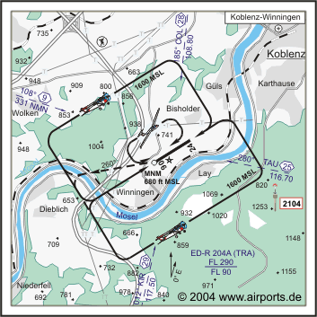
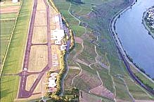
Koblenz-Winningen Airfield |
In zentraler Lage, mit kurzen Anfahrtzeiten, optimalen Start- und Landemöglichkeiten
ohne unnötige Wartezeiten beim Check-in, bei unbegrenztem und kostenlosem
Parken finden Sie ideale Voraussetzungen, Ihre geschäftlichen oder
privaten Ziele stressfrei zu erreichen. Unterbringungsmöglichkeiten
für Ihr Flugzeug, die moderne Tankstellenanlage, ein fachkundiger
Wartungs- und Reparaturservice, Räume für Besprechungen sowie
nicht zuletzt unser einladendes Flugplatz-Restaurant runden das Angebot
ab.
ICAO Code EDRK
Name KOBLENZ - Winningen
Land Deutschland
Bundesland Rheinland-Pfalz
Letzte Änderung 24. Juli 2003
Kategorie Verkehrslandeplatz / Public Airfield
Betreiber / Operator Flugplatz Koblenz-Winningen GmbH
Lage / Location 2.7 NM SW Koblenz
LFZ / ACFT Bis / up to 5700 kg, 10000 kg PPR
Helicopter Ja / Yes
Motorsegler / GLDP Ja / Yes
Segelflugzeuge / GLD Ja / Yes
UL Ja / Yes
Dreiachsgesteuerte/triple-axled UL
Summer MON-FRI 0600-SS+30/1900, SAT,SUN,HOL 0700-SS+30/1900
Winter MON-FRI 0700-SS+30/1900, SAT, SUN, HOL 0800-SS+30/1900,
O/T PPR
An SUN, HOL sind Schulflüge sowie Flüge zur Einweisung oder
zum Vertrautmachen von Luftfahrzeugführern, die in der Platzrunde
durchgeführt werden müssen, untersagt./ On SUN, HOL training
flights, as well as flights to brief and familiarize pilots which have
to be conducted in the traffic circuit, are prohibited. Weiter Einschränkungen
siehe AD 1-6/ additional restrictions see AD 1-6
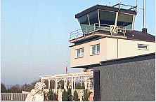
Luftaufsicht / OPS +49 (0)2606 / 822, 1030, Fax 348
AIS AIS-Centre EDDZ, +49 (0)69 / 78072500
ACC EDDF +49 (0)6103 / 7076200
MET (0190) 077223
Gafor 38
 Zoll / Customs O / R 1 HR vor/before ARR, Für Personenbeförderung
im nichtgewerblichen Verkehr oder im Gelegenheitsverkehr/for passengers-transportation
in non-commercial or non-scheduled traffic
Zoll / Customs O / R 1 HR vor/before ARR, Für Personenbeförderung
im nichtgewerblichen Verkehr oder im Gelegenheitsverkehr/for passengers-transportation
in non-commercial or non-scheduled traffic
Zoll / Customs Fon O/R 1HR vor/before ARR/DEP 02606 / 1030. Für Personenbeförderung
im nichtgewerblichen Verkehr oder im Gelegenheitsverkehr/for passenger-transportation
in non-commercial or non-scheduled traffic
Fuel 100 LL, Jet A1, Super plus, Kein Carnet,./ Carnets will not be accepted.Folgende
Kreditkarten werden akzeptiert/following creditcards are accepted: American
Express, Eurocard, Diners-Club, Visa
Oil D 80, D 100, 80, 100, 15W50
Hangar Beschränkt / Limited
Höhe / Elevation 640 ft / 195 m
FIS Langen Information 123.525
VDF / QDM 122.650
Rufzeichen / Call sign Koblenz Info
Frequenz Tower 122.650 EN/GE
NAV Aids 109°/9 NM from NMN NDB 331 186°/28 NM from COL DVORTAC
108.80/Ch 25 013°/29 NM from KIR VORTAC 117.50/Ch 122 281°/25
NM from TAU 116.70
Koordinaten 50 19, 53 N / 07 31, 72 E
Platzrunde / Traffic circuit SE 1600 NW 1600
Landebahnen / RWY 1
RWY 1175 x 20 m, ASPHALT
RWY 06 TKOF 1175 m; LDG 995 m
RWY 24 TKOF 995 m; LDG 1175 m
MTOW 5700 kg
Bemerkungen / Remarks Wohngebiete meiden! GLD + PJE! Hindernis/OBST (2104
MSL) 2 NM SE! Hochspannungsleitung 0.9 NM W THR 06! UL-Betrieb!
Restaurant - Yes
 Adresse
Flugplatz
ZIP / City D-56333
Winningen
Telefon: 02606 822
Telefax: 02606 348
URL http://www.flugplatz-koblenz-winningen.de
e-Mail: flugplatz_kowi at t-online
de
Images and information placed above are from http://www.flugplatz-koblenz-winningen.de
http://www.airports.de/airport.php?ICAO=EDRK
We thank them for the data!
| General Info
|
| Country |
Germany
|
| ICAO ID |
EDRK
|
| Time |
UTC+1(+2DT)
|
| Latitude |
50.325500
50° 19' 31.80" N
|
| Longitude |
7.528667
007° 31' 43.20" E
|
| Elevation |
640 feet
195 meters
|
| Magnetic Variation |
000° E (01/05)
|
| Beacon |
Yes
|
| Operating Agency |
CIVIL GOVERNMENT, (LANDING FEES AND DIPLOMATIC CLEARANCE MAY BE REQUIRED)
|
| Operating Hours |
SEE REMARKS FOR OPERATING HOURS OR COMMUNICATIONS FOR POSSIBLE HOURS
|
| Daylight Savings Time |
Last Sunday in March to last Sunday in October
|
| Communications
|
| INFO |
122.65
|
| LANGEN INFO |
123.525
|
| Runways
|
ID
|
Dimensions |
Surface |
PCN |
ILS
|
| 06/24 |
3855 x 66 feet
1175 x 20 meters |
ASPHALT |
- |
NO
|
| Supplies/Equipment
|
| Fuel |
Jet A1, without icing nhibitor.
100/130 MIL Spec, low lead, aviation gasoline (BLUE)
|
| Remarks
|
| CAUTION |
Rwy 06 pwr line 5600' prior to thld 880' MSL. PJE and gldr act.
|
| CSTMS/IMG |
CSTMS avbl O/R 1 hr PN.
|
| FUEL |
(NC-100LL, A1)
|
| NS ABTMT |
Avoid ovft of Bisholder, Guis, Moselweiss, Karthause, Lay, Winningen and Dieblich.
|
| OPR HOURS |
Opr 0700Z++-SS+30/1900Z Mon-Fri; 0800Z++-SS+30/1900Z Sat, Sun and hol; OT PPR.
|
| RSTD |
No acft dep when amber flg lgt at rwy hold posn on. PPR for acft AUW 12.5 to AUW22. Rwy 24 TODA 3264'.
|
Runway 06/24
3855 x 66 feet
1175 x 20 meters
| Runway 06
|
| Surface |
ASPHALT
|
| True Heading |
058.0
|
| Latitude |
50.321544
50° 19' 17.56" N
|
| Longitude |
7.520494
007° 31' 13.78" E
|
| Landing Distance |
3264 feet
995 meters
|
| Takeoff Distance |
3855 feet
1175 meters
|
| Displaced Threshold Length |
591 feet
180 meters
|
| Lighting System |
V
LIGHTS |
| Runway 24
|
| Surface |
ASPHALT
|
| True Heading |
238.0
|
| Latitude |
50.327122
50° 19' 37.64" N
|
| Longitude |
7.534506
007° 32' 04.22" E
|
| Landing Distance |
3855 feet
1175 meters
|
| Takeoff Distance |
3855 feet
1175 meters
|
| Lighting System |
V
LIGHTS |
The content above was published at Airports-Worldwide.com in 2005.
We don't guarantee the information is fresh and accurate. The data may be wrong or outdated.
For more up-to-date information please refer to other sources.
|
|


