|

Welcome to Rostock-Laage Airport
Modern, service-orientated, professional - that’s how passengers
and visitors see the airport in Mecklenburg-Western Pommerania.
Quality and customer care are matters of course for 60 airport employees.
Day after day they’re mastering their complex work flows (almost)
with perfection.
Every business section of the airport like ground traffic service, passage,
or traffic control is subject to a permanent quality management following
Lufthansa standards. Not least it’s due to the German Air Force
that the airport meets international standards.
Rostock-Laage is a popular airport. Both business travellers and tourists
appreciate the individual atmosphere and the extensive service which is
improved every day.
HISTORY:
1992
project planning, construction, and completion of the terminal
May 1994
start of the night airmail service for the entire state of Mecklenburg-Western
Pommerania
November 1995
first charter tour to Istanbul with PTI-Panoramica
April 1996
Neckermann, TUI, and PTI-Panoramica depart from Rostock-Laage for new
destinations: Majorca, Tunisia, Turkey, Gran Canaria, Malta, Paris
 1997
1997
ÖGER TOURS, Bucher Reisen, and 1,2 Fly offer new destinations from
Rostock-Laage: Malta, Tenerife und Lanzarote 80.000 passengers depart
from Rostock-Laage with different tour operators
March 1998
Completion of a new departure area (Departure B)
May 1998
ITS debut
14 October 1998
Rostock-Laage Airport welcomes its 250,000th passenger
May 1999
Inauguration of car park P4 - overall parking space for 600 cars, free
of charge
The airport becomes an airfreight base of LH Cargo
9 September 2000
1st airport celebration day
November 2001
Air Berlin is the first airline based in Rostock-Laage serving 22 destinations
2 May 2002
Cirrus-Airlines takes up regular service between Rostock and Munich
October 2002
Inauguration of car park P5, overall parking space for 800, free of charge
November 2003
Subsidies for the new terminal are granted
 ICAO Code ETNL
IATA Code RLG
Name LAAGE
Land Deutschland
Bundesland Mecklenburg-Vorpommern
Letzte Änderung 9. März 2002
Kategorie Militär- und ziviler Verkehrsflughafen /
Betreiber / Operator 1. Bundeswehr 2. FRLG Flughafen Rostock-Laage-Güstrow
GmbH
Lage / Location 2.4 NM W Laage
Nachtflug / NVFR NVFR
Instrumentenflug / IFR IFR
LFZ / ACFT Bis / up to PCN 66
Summer MON-FRI 0600-1900, SAT, SUN 0800-1600 CTR H 24
Winter MON-FRI 0700-2000, SAT, SUN 0900-1700 CTR H 24
Luftaufsicht / OPS +49 (0)38454 / 31331, Fax 31333
AIS EDDB +49 (0)30 / 60918250
MET (0190) 077222
Gafor 11
 Zoll / Customs JA/YES, PPR H 24
Fuel 100 LL, Jet A1, Super bleifrei/unleaded
Oil Aero Oil 80/100, W80/100, 15W/50, AW15W/50
Hangar Nein / No
Höhe / Elevation 138 ft / 42 m
FIS Berlin Information 126.350
Rufzeichen / Call sign Laage TowerITurm
Frequenz Tower 118.425 EN/GE
NAV Aids ABN DME/TACAN LAG Ch 89y/114.25 am Platz/at field NDB LAG 383
278°/2.2 NM TO THR 28
Koordinaten 53 55, 02 N / 12 16, 72 E
Landebahnen / RWY 1
RWY 2500 x 45 m, CONCRETE
RWY 10 TKOF 2500 m; LDG 2500 m
RWY 28 TKOF 2500 m; LDG 2500 m
MTOW PCN 66R/A/W/U
Bemerkungen / Remarks TWR/CTR: H 24!
Restaurant - Yes
Adresse
2. Parkstraße 105
ZIP / City D-18299 Weitendorf
Flughafen Rostock-Laage-Güstrow GmbH
Mr Jürgen Roske, ppa.
Manager Operation & Traffic Department
Tel. +49(0) 38454 313 30
Fax +49(0) 38454 313 35
Mobil +49(0) 172 3863284
j roske at rostock-airport de
URL http://www.rostock-airport.de
eMail Rostock-airport at t-online de
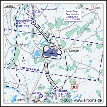
Images and information placed above are from http://www.airports.de/airport.php?ICAO=ETNL
http://www.rostock-airport.de
We thank them for the data!
| General Info
|
| Country |
Germany
|
| ICAO ID |
ETNL
|
| Time |
UTC+1(+2DT)
|
| Latitude |
53.918167
53° 55' 05.40" N
|
| Longitude |
12.278333
012° 16' 42.00" E
|
| Elevation |
138 feet
42 meters
|
| Type |
Joint (Civil and Military)
|
| Magnetic Variation |
001° E (01/05)
|
| Beacon |
Yes
|
| Operating Agency |
GERMAN AIR FORCE
|
| Alternate Name |
ROSTOCK LAAGE AIRPORT
|
| Operating Hours |
SEE REMARKS FOR OPERATING HOURS OR COMMUNICATIONS FOR POSSIBLE HOURS
|
| Daylight Savings Time |
Last Sunday in March to last Sunday in October
|
| Communications
|
| TWR |
118.425
122.1
143.925
336.4
257.8
|
| RADAR |
123.3
133.625
139.75
142.0
309.75
|
| BERLIN INFO |
126.35
|
| BERLIN RADAR |
134.65
126.175
241.725
379.925
|
| Runways
|
ID
|
Dimensions |
Surface |
PCN |
ILS
|
| 10/28 |
8202 x 148 feet
2500 x 45 meters |
CONCRETE. |
066RAWU |
YES
|
| Navaids
|
| Type |
ID |
Name |
Channel |
Freq |
Distance From Field |
Bearing From Navaid
|
| TACAN |
LAG |
LAAGE |
019Y |
- |
At Field |
-
|
| Supplies/Equipment
|
| Fuel |
JP-8, SemiKeroscene MIL Spec T-83133, without icing inhibitor
|
| Oil |
O-148, MIL L 7808 (Synthetic Base), Turboprop/Turboshaft Engine
O-155, MIL L 6068C, Aircraft Medium Grade
O-156, MIL L 23699 (Synthetic Base)Turboprop/Turboshaft Engine
|
| JASU |
RST-180
75kva AC 115/200v 400hz AIR 145-155lb/min at 47-51 psi
|
| Remarks
|
| A-GEAR |
HOOK 44B-2D(B) (966') both directions O/R 10 min. Net barrier Rwy 10/28 not avbl.
|
| FUEL |
J8 (NC-100LL, A1)
|
| MISC |
Class D Airspace, OT Class E. Fone 038459-62-2323 WOC, Ftr Wg 73.
|
| OIL |
O-148-155-156
|
| OPR HOURS |
Opr 0700-1600Z++ Mon-Thu; 0700-1100Z++ Fri, PPR 24 hr; clsd hol. (Civ 0700-2000Z++ Mon-Fri, 0900-1700Z++ Sat and Sun, OT PPR).
|
| RSTD |
PPR 24 hr due to ltd cross svc.
|
Runway 10/28
8202 x 148 feet
2500 x 45 meters
| Runway 10
|
| Surface |
CONCRETE.
|
| True Heading |
098.0
|
| Latitude |
53.919667
53° 55' 10.80" N
|
| Longitude |
12.260333
012° 15' 37.20" E
|
| Elevation |
138.0 feet
42 meters
|
| Slope |
-0.3°
|
| Landing Distance |
8202 feet
2500 meters
|
| Takeoff Distance |
9203 feet
2805 meters
|
| Overrun Length |
1001 feet
305 meters
|
| Overrun Surface |
GRASS OR EARTH NOT GRADED OR ROLLED.
|
| Lighting System |
SF
HIRL
BP
PAPI |
| Runway 28
|
| Surface |
CONCRETE.
|
| True Heading |
278.0
|
| Latitude |
53.916500
53° 54' 59.40" N
|
| Longitude |
12.298167
012° 17' 53.40" E
|
| Elevation |
110.0 feet
34 meters
|
| Slope |
0.3°
|
| Landing Distance |
8202 feet
2500 meters
|
| Takeoff Distance |
9203 feet
2805 meters
|
| Overrun Length |
1001 feet
305 meters
|
| Overrun Surface |
GRASS OR EARTH NOT GRADED OR ROLLED.
|
| Lighting System |
SF
HIRL
BP
PAPI |
Navaids
| LAAGE
|
| Type |
ID |
Channel |
Freq |
Country |
State
|
| TACAN |
LAG |
019Y |
- |
Germany |
-
|
| Latitude |
Longitude |
Airport
|
53.920167
53° 55' 12.60" N |
12.286000
012° 17' 09.60" E |
ETNL |
The content above was published at Airports-Worldwide.com in 2005.
We don't guarantee the information is fresh and accurate. The data may be wrong or outdated.
For more up-to-date information please refer to other sources.
|


