 |
|
 ICAO
Code EDWF ICAO
Code EDWF
Name LEER - Papenburg
Land Deutschland
Bundesland Niedersachsen
Letzte Änderung 31. März 2005
Kategorie Verkehrslandeplatz / Public Airfield
Betreiber / Operator Flugplatzgesellschaft Leer-Papenburg GmbH
Internet Nein
Lage / Location 1.9 NM N Leer
Nachtflug / NVFR NVFR
LFZ / ACFT Bis / up to 5700 kg, 10000 kg PPR,
Helicopter Ja / Yes
Motorsegler / GLDP Ja / Yes
Segelflugzeuge / GLD Ja / Yes
UL Ja / Yes
Summer MON-FRI 0600-1700/MAX SS, SAT, SUN +HOL 0700-1700/MAX SS
Winter MON-FRI 0700-SS, SAT, SUN + HOL 0800-SS
O/T PPR
Luftaufsicht / OPS +49 (0)491 / 5566, Fax 9261388
PPR +49 (0)491 / 5566, Fax 9261388
AIS AIS-Centre +49 (0)69 / 78072500
ACC EDDW +49 (0)421 / 5372120
MET (0190) 077221
Gafor 5
Zoll / Customs O / R 2 HR vor/before ARR
Fuel 100 LL, Jet A1
Oil W 80, W 100, unl. 80, W15/50
Hangar Ja / Yes
Höhe / Elevation 3 ft / 1 m
FIS Bremen Information 125.100
VDF / QDM 130.775 122.500 123.000 123.650
Rufzeichen / Call sign Leer Info
Frequenz Tower 130.775 GE
NAV Aids ABN 077°/29 NM from EEL VOR/DME 112.40/Ch 71 235°/25
NM from JEV NDB 390, 234°/35NM From "BMN"(117.45)
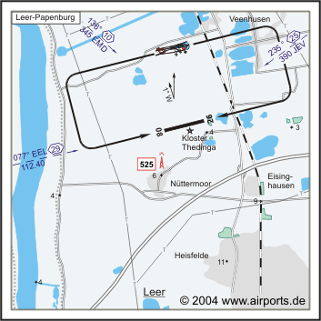
Koordinaten 53 16, 33 N / 07 26, 58 E
Platzrunde / Traffic circuit N 1000
Landebahnen / RWY 1
RWY 1200 x 20 m, ASPHALT
RWY 08 TKOF 1200 m; LDG 1200 m
RWY 26 TKOF 1200 m; LDG 1200 m
MTOW 5700 kg. PPR 10000kg, HEL 5700 kg
Bemerkungen / Remarks Fernmeldeturm/Telecomm. Tower 0.5 NM SSW (525 MSL)!
GLD! UL acft PPR!
Restaurant - Yes
Adresse
Friesenstraße 46
ZIP / City D-26787 Leer
Fon +49 (0)491 / 9260, 9261252
WEB: http://www.airports.de/airport.php?ICAO=EDWF
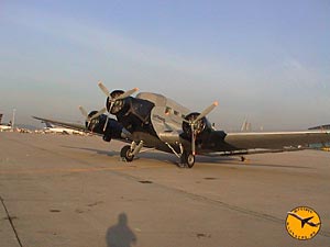 Picture by Ludwig Lohwieser
Images and information placed above are from http://www.airports.de/airport.php?ICAO=EDWF
http://aircraftpicturesde.piranho.com/lufthansaju52.html
We thank them for the data!
| General Info
|
| Country |
Germany
|
| ICAO ID |
EDWF
|
| Time |
UTC+1(+2DT)
|
| Latitude |
53.271592
53° 16' 17.73" N
|
| Longitude |
7.442344
007° 26' 32.44" E
|
| Elevation |
3 feet
1 meters
|
| Magnetic Variation |
000° E (01/05)
|
| Beacon |
Yes
|
| Operating Agency |
CIVIL GOVERNMENT, (LANDING FEES AND DIPLOMATIC CLEARANCE MAY BE REQUIRED)
|
| Alternate Name |
LEER NUTTERMOOR
|
| Communications
|
| INFO |
130.775
|
| BREMEN INFO |
125.1
|
| Runways
|
ID
|
Dimensions |
Surface |
PCN |
ILS
|
| 08/26 |
3937 x 66 feet
1200 x 20 meters |
ASPHALT |
- |
NO
|
| Supplies/Equipment
|
| Fuel |
100/130 octane gasoline, leaded, MIL-L-5572F (GREEN)
100/130 MIL Spec, low lead, aviation gasoline (BLUE)
|
| Remarks
|
| CSTMS/IMG |
Avbl O/R 2 hr before arr.
|
| FUEL |
(NC-100LL, A1)
|
| OPR HOURS |
Opr 0700Z-SS Mon- Fri; 0800Z-SS Sat, Sun, hol; OT PPR. (0600-1700Z/Max SS Mon-Fri; 0700-1700Z/Max SS Sat, Sun, hol; OT PPR DT).
|
Runway 08/26
3937 x 66 feet
1200 x 20 meters
| Runway 08
|
| Surface |
ASPHALT
|
| True Heading |
079.0
|
| Latitude |
53.270581
53° 16' 14.09" N
|
| Longitude |
7.433511
007° 26' 00.64" E
|
| Landing Distance |
3937 feet
1200 meters
|
| Takeoff Distance |
3937 feet
1200 meters
|
| Lighting System |
LIRL
PAPI |
| Runway 26
|
| Surface |
ASPHALT
|
| True Heading |
259.0
|
| Latitude |
53.272597
53° 16' 21.35" N
|
| Longitude |
7.451086
007° 27' 03.91" E
|
| Landing Distance |
3937 feet
1200 meters
|
| Takeoff Distance |
4134 feet
1260 meters
|
| Overrun Length |
197 feet
60 meters
|
| Overrun Surface |
ASPHALT
|
| Lighting System |
LIRL
PAPI |
The content above was published at Airports-Worldwide.com in 2005.
We don't guarantee the information is fresh and accurate. The data may be wrong or outdated.
For more up-to-date information please refer to other sources.
|
|


