 |
|
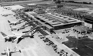
 Leipzig/Halle Airport celebrated its 70th anniversary in 1997.
It was on Easter Monday in 1927 that an airport - which was very modern
in its time - opened after very short construction time north of the town
of Schkeuditz, half way between the cities of Halle and Leipzig.
That date forms the clear starting point for the history of the airport,
you might think, and you would expect a continuous development towards
the efficient air traffic facilities we have today. But the history of
aviation in the region was very troubled. The ups and downs in the development
can only be understood in the context of the eventful German history of
the 20th century. Two world wars had crucial influence on the development
of the airports around Halle and Leipzig, as had the political difficulties
of the Weimar Republic, the National Socialists' preparations for the
war, and the political and economic post-war situation.
We will thus have to range further afield than the beginnings of air
traffic in Leipzig and Halle from which the airports in Halle Nietleben
and Leipzig Mockau evolved. We will then present a chronicle of the Schkeuditz
facilities from the early days to the present Leipzig/Halle Airport.
 ICAO Code EDDP
IATA Code LEJ
Name LEIPZIG/Halle
Land Deutschland
Bundesland Sachsen
Letzte Änderung 9. April 2004
Kategorie Int. Verkehrsflughafen / Int. Airport
Betreiber / Operator Flughafen Leipzig/Halle GmbH
Lage / Location 6.5 NM WNW von/of Leipzig, 9.7 NM ESE von/of Halle
Nachtflug / NVFR NVFR
Instrumentenflug / IFR IFR
LFZ / ACFT Bis / up to PCN 70 R/D/X/T
Helicopter Ja / Yes
Motorsegler / GLDP Ja / Yes
Ballone Ja / Yes
Summer H 24, CTR H 24
Winter H 24, CTR H 24
GAT täglich/daily 0500-2100 (0400-200) Traningsflüge: Die vorherige
Genehmigung durch den Flughafenunternehmer ist erforderlich für unmittelbar
aufeinanderfolgende, wiederholte ARR/DEP zu Übungszwecken. Trainingflights:
Previous permission by airport operator is necessary for repeated ARR/DEP
immediately following one another of AFCT at Leipzig-Halle APT for training
purposes.
Luftaufsicht / OPS +49 (0)341 / 2242863 (GAT)
AIS AIS-Centre EDDZ, +49 (0)69 / 78072500
MET (0190) 077226
Gafor 22
Zoll / Customs Ja/Yes
Fuel 100 LL, Jet A1
Oil 100, EE 80, EE 100, E 100, E80, Multigrade
Hangar Nein / No
Höhe / Elevation 465 ft / 142 m
FIS Berlin Information 125.800, Berlin Radar 124.175
VDF / QDM 121.100
Rufzeichen / Call sign Leipzig Tower/Turm
Frequenz Tower 121.100 EN/GE
Frequenz Ground 121.800 EN/GE
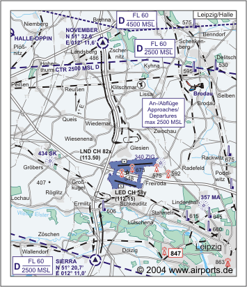
NAV Aids ABN PAPI DME LND 113.50/LED 112.15 am Platz/at field ILS RWY
26 108.35 ILS RWY 28 110.30 ILS RWY 08 110.55 ILS RWY 10 111.90
Koordinaten 51 25, 44 N / 12 14, 18 E
Landebahnen / RWY 2
RWY 3600 x 45 m, CONCRETE
RWY 08 TKOF 3600 m; LDG 3600 m
RWY 26 TKOF 3600 m; LDG 3600 m
MTOW PCN 80 R/C/X/T
RWY II 2500 x 51 m, CONCRETE
RWY 10 TKOF 2500 m; LDG 2500 m
RWY 28 TKOF 2500 m; LDG 2500 m
MTOW RWY II PCN 70 R/D/X/T
Restaurant - Yes
Adresse
Postfach 1
ZIP / City D-04029 Leipzig
Fon +49 (0)341 / 2240
URL http://www.leipzig-halle-airport.de
eMail mail_flh at leipzig-halle-airport de
Images and information placed above are from http://www.airports.de/airport.php?ICAO=EDDP
http://www.leipzig-halle-airport.de
We thank them for the data!
| General Info
|
| Country |
Germany
|
| ICAO ID |
EDDP
|
| Time |
UTC+1(+2DT)
|
| Latitude |
51.423992
51° 25' 26.37" N
|
| Longitude |
12.236383
012° 14' 10.98" E
|
| Elevation |
465 feet
142 meters
|
| Type |
Civil
|
| Magnetic Variation |
001° E (05/05)
|
| Beacon |
Yes
|
| Operating Agency |
CIVIL GOVERNMENT, (LANDING FEES AND DIPLOMATIC CLEARANCE MAY BE REQUIRED)
|
| Alternate Name |
SCHKEUDITZ
|
| Operating Hours |
24 HOUR OPERATIONS
|
| Daylight Savings Time |
Last Sunday in March to last Sunday in October
|
| Communications
|
| TWR |
121.1
119.7
376.55
|
| BERLIN INFO |
125.8
|
| GND |
121.8
|
| ATIS |
123.95
|
APP
Call BERLIN RADAR
|
124.175
387.675
|
| Runways
|
ID
|
Dimensions |
Surface |
PCN |
ILS
|
| 08/26 |
11810 x 148 feet
3600 x 45 meters |
CONCRETE. |
080RCXT |
YES
|
10/28
CLOSED |
8202 x 167 feet
2500 x 51 meters |
CONCRETE. |
070RDXT |
YES
|
| Navaids
|
| Type |
ID |
Name |
Channel |
Freq |
Distance From Field |
Bearing From Navaid
|
| VOR-DME |
LEG |
LEIPZIG |
105Y |
115.85 |
8.9 NM |
263.9
|
| NDB |
ZIG |
LEIPZIG |
- |
340 |
1.8 NM |
248.6
|
| DME |
LND |
LEIPZIG NORTH |
082X |
- |
At Field |
-
|
| Supplies/Equipment
|
| Fuel |
Jet A1, without icing nhibitor.
100/130 MIL Spec, low lead, aviation gasoline (BLUE)
|
| Remarks
|
| CAUTION |
Possible wake turb. Bird haz.
|
| CSTMS/IMG |
Avbl.
|
| FLUID |
De-Ice avbl.
|
| FUEL |
(NC-100LL, A1)
|
| LGT |
PAPI Rwy 10 MEHT 54', Rwy 28 MEHT 50', Rwy 08 MEHT 57', Rwy 26 MEHT 56'.
|
| MISC |
Ldg fees.
|
| RSTD |
Rwy 08-26 is prim rwy, Rwy 10-28 use PPR.
|
Runway 08/26
11810 x 148 feet
3600 x 45 meters
| Runway 08
|
| Surface |
CONCRETE.
|
| True Heading |
085.7
|
| Latitude |
51.431242
51° 25' 52.47" N
|
| Longitude |
12.215825
012° 12' 56.97" E
|
| Elevation |
418.0 feet
127 meters
|
| Slope |
0.3°
|
| Landing Distance |
11810 feet
3600 meters
|
| Takeoff Distance |
11810 feet
3600 meters
|
| Lighting System |
SF
TDZL
CL
HIRL
REIL
A
PAPI |
| Runway 26
|
| Surface |
CONCRETE.
|
| True Heading |
265.7
|
| Latitude |
51.433647
51° 26' 01.13" N
|
| Longitude |
12.267444
012° 16' 02.80" E
|
| Elevation |
448.0 feet
137 meters
|
| Slope |
-0.3°
|
| Landing Distance |
11810 feet
3600 meters
|
| Takeoff Distance |
11810 feet
3600 meters
|
| Lighting System |
SF
TDZL
CL
HIRL
REIL
A
PAPI |
Navaids
| LEIPZIG
|
| Type |
ID |
Channel |
Freq |
Country |
State
|
| VOR-DME |
LEG |
105Y |
115.85 |
Germany |
-
|
| Latitude |
Longitude |
Airport
|
51.436006
51° 26' 09.62" N |
12.473206
012° 28' 23.54" E |
EDDP |
Navaids
| LEIPZIG NORTH
|
| Type |
ID |
Channel |
Freq |
Country |
State
|
| DME |
LND |
082X |
- |
Germany |
-
|
| Latitude |
Longitude |
Airport
|
51.434314
51° 26' 03.53" N |
12.225706
012° 13' 32.54" E |
EDDP |
The content above was published at Airports-Worldwide.com in 2005.
We don't guarantee the information is fresh and accurate. The data may be wrong or outdated.
For more up-to-date information please refer to other sources.
|
 |


