 |
|
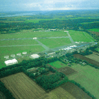
Lübeck Blankensee Airport |
 ICAO Code EDHL
IATA Code LBC
Name LUBECK - Blankensee
Land Deutschland
Bundesland Schleswig-Holstein
Letzte Anderung 30. Juni 2005
Kategorie Verkehrsflughafen / Airport
Betreiber / Operator Flughafen Lübeck GmbH
Lage / Location 2.5 NM S Lübeck
Nachtflug / NVFR NVFR
Instrumentenflug / IFR IFR
LFZ / ACFT Bis / up to PCN 55/R/B/W/T
Fallschirmspringen / PJE Ja / Yes
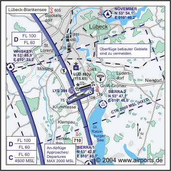
Summer MON-FRI 0530-2100, SAT, SUN, HOL 0530-1900 CTR HX
Winter MON-FRI 0630-2200, SAT, SUN, HOL 0630-2000 CTR HX
O/T PPR
Einschränkungen siehe Kartenteil/ restrictions see chart section
An Sonn- und Feiertagen in der Zeit von 1200-1400 (1100-1300) sind private
Platzrundenflüge, Rund und Besichtigungsflüge unter 1 Std Dauer,
sowie Absetzflüge für Fallschirmspringer untersagt.
Luftaufsicht / OPS +49 (0)451 / 52235, 583010, TWR 5830115
PPR +49 (0)451/ 5830138, 583010
AIS AIS-Centre +49 (0)69 / 78072500
ACC EDDW +49 (0)421 / 5372120
MET (0190) 077221
Gafor 4
 Zoll / Customs O / R 1 HR Für ARR+ DEP von Flugzeugen die im nichtgewerblichen
Verkehr und gewerblichen Gelegenheitsverkehr zur Personenbeförderung
in das Zollgebiet einfliegen oder aus dem Zollgebiet ausfliegen./ For
ARR+DEP of non-commercial non-scheduled aircraft transporting passengers
into or out of the customs area.
Zoll / Customs O / R 1 HR Für ARR+ DEP von Flugzeugen die im nichtgewerblichen
Verkehr und gewerblichen Gelegenheitsverkehr zur Personenbeförderung
in das Zollgebiet einfliegen oder aus dem Zollgebiet ausfliegen./ For
ARR+DEP of non-commercial non-scheduled aircraft transporting passengers
into or out of the customs area.
Fuel 100 LL, Jet A1
Oil E 80, E 100, 100, 15W50
Hangar O / R
Höhe / Elevation 53 ft / 16 m
FIS Bremen Information 125.100, Lübeck Atis 119.925
VDF / QDM 128.700
Rufzeichen / Call sign Lübeck Tower/Turm (Lübeck Info)
Frequenz Tower 128.700 EN/GE
Frequenz Ground Lübeck Ground 121.775
NAV Aids ABN PAPI NDB/ LYE 394 072°/0.4 NM TO THR 07 069°/20 NM
from HAM VORTAC 113.10/Ch 78 167°/9 NM from LUB VOR 110.60 DME LUD
115.65 am Platz/at field
Koordinaten 53 48, 32 N / 10 43, 15 E
Platzrunde / Traffic circuit S N 1000
Landebahnen / RWY 1
RWY 2102 x 60 m, ASPHALT
RWY 07 TKOF 2102 m; LDG 1802 m
RWY 25 TKOF 2102 m; LDG 2102 m
MTOW PCN 55 R/B/W/T
Bemerkungen / Remarks TWR/CTR: MON-FRI 0830-1730 (0730-1730) EXC HOL OT
INFO! GLD + PJE! UL-Betrieb! Wohngebiete meiden! Naturschutzgebiet Schaalsee
nicht unter 2000 GND überfliegen!
Restaurant - Yes
 Adresse Adresse
Adresse Blankenseerstraße 101
ZIP / City D-23560 Lübeck
Fon +49 (0)451 / 583010
Fax 5830124
URL http://www.flughafen-luebeck.de
eMail info at flughafen-luebeck de
Images and information placed above are from http://www.airports.de/airport.php?ICAO=EDHL
http://www.flughafen-luebeck.de
We thank them for the data!
| General Info
|
| Country |
Germany
|
| ICAO ID |
EDHL
|
| Time |
UTC+1(+2DT)
|
| Latitude |
53.805367
53° 48' 19.32" N
|
| Longitude |
10.719222
010° 43' 09.20" E
|
| Elevation |
53 feet
16 meters
|
| Type |
Civil
|
| Magnetic Variation |
001° E (01/05)
|
| Beacon |
Yes
|
| Operating Agency |
CIVIL GOVERNMENT, (LANDING FEES AND DIPLOMATIC CLEARANCE MAY BE REQUIRED)
|
| Operating Hours |
SEE REMARKS FOR OPERATING HOURS OR COMMUNICATIONS FOR POSSIBLE HOURS
|
| Daylight Savings Time |
Last Sunday in March to last Sunday in October
|
| Communications
|
TWR
Opr 0830-1730Z++Mon-Fri exc hol.
|
128.7
|
| BREMEN RADAR |
124.225
299.85
|
| INFO |
128.7
|
| GND |
121.775
|
| ATIS |
119.925
|
| BREMEN INFO |
125.1
376.7
|
| Runways
|
ID
|
Dimensions |
Surface |
PCN |
ILS
|
| 07/25 |
6896 x 197 feet
2102 x 60 meters |
ASPHALT |
055RBWT |
YES
|
| Navaids
|
| Type |
ID |
Name |
Channel |
Freq |
Distance From Field |
Bearing From Navaid
|
| VOR |
LUB |
LUBECK |
- |
110.6 |
8.3 NM |
166.4
|
| NDB |
LYE |
LUBECK BLANKENSEE |
- |
394 |
At Field |
-
|
| DME |
LUD |
LUBECK BLANKENSEE |
103Y |
- |
At Field |
-
|
| Supplies/Equipment
|
| Fuel |
Jet A1, without icing nhibitor.
100/130 MIL Spec, low lead, aviation gasoline (BLUE)
|
| Oil |
Available (Types unknown)
|
| Remarks
|
| CAUTION |
Windshear posssible on short final Rwy 25 with NW wind. PJE and gldr act vcnty arpt. Bird haz.
|
| CSTMS/IMG |
Avbl O/R 2 hrs PN.
|
| FUEL |
(NC-100LL, A1)
|
| MISC |
Class D Airspace eff 0830-1730Z Mon-Fri (0730-1730Z Mon-Fri DT); clsd hol; OT Class E.
|
| NS ABTMT |
Tfc pat circuits proh 1200-1400Z++, Sun and hol.
|
| OPR HOURS |
Opr 0630-2200Z++ Mon-Fri; 0630-2000Z++ Sat, Sun, hol. OT PPR.
|
| RSTD |
Ovft of built-up areas incl the wildlife reserve Schaalsee shall be avoided blw 2000'.
|
Runway 07/25
6896 x 197 feet
2102 x 60 meters
| Runway 07
|
| Surface |
ASPHALT
|
| True Heading |
072.0
|
| Latitude |
53.802047
53° 48' 07.37" N
|
| Longitude |
10.701886
010° 42' 06.79" E
|
| Elevation |
53.0 feet
16 meters
|
| Slope |
-0.1°
|
| Landing Distance |
5912 feet
1802 meters
|
| Takeoff Distance |
6896 feet
2102 meters
|
| Displaced Threshold Length |
984 feet
300 meters
|
| Lighting System |
HIRL
A2
PAPI |
| Runway 25
|
| Surface |
ASPHALT
|
| True Heading |
252.0
|
| Latitude |
53.807878
53° 48' 28.36" N
|
| Longitude |
10.732231
010° 43' 56.03" E
|
| Elevation |
47.0 feet
14 meters
|
| Slope |
0.1°
|
| Landing Distance |
6896 feet
2102 meters
|
| Takeoff Distance |
6896 feet
2102 meters
|
| Lighting System |
HIRL
A2
PAPI |
Navaids
| LUBECK
|
| Type |
ID |
Channel |
Freq |
Country |
State
|
| VOR |
LUB |
- |
110.6 |
Germany |
-
|
| Latitude |
Longitude |
Airport
|
53.940742
53° 56' 26.67" N |
10.667786
010° 40' 04.03" E |
EDHL |
Navaids
| LUBECK BLANKENSEE
|
| Type |
ID |
Channel |
Freq |
Country |
State
|
| NDB |
LYE |
- |
394 |
Germany |
-
|
| Latitude |
Longitude |
Airport
|
53.800825
53° 48' 02.97" N |
10.695858
010° 41' 45.09" E |
EDHL |
Navaids
| LUBECK BLANKENSEE
|
| Type |
ID |
Channel |
Freq |
Country |
State
|
| DME |
LUD |
103Y |
- |
Germany |
-
|
| Latitude |
Longitude |
Airport
|
53.806392
53° 48' 23.01" N |
10.718631
010° 43' 07.07" E |
EDHL |
The content above was published at Airports-Worldwide.com in 2005.
We don't guarantee the information is fresh and accurate. The data may be wrong or outdated.
For more up-to-date information please refer to other sources.
|
|


