|
ICAO Code EDKZ
Name MEINERZHAGEN
Land Deutschland
Bundesland Nordrhein-Westfalen
Letzte Änderung 13. November 2003
Kategorie Sonderlandeplatz / Special Airfield
Betreiber / Operator Flugplatz Meinerzhagen GmbH
Lage / Location 1,62 NM W Meinerzhagen
LFZ / ACFT Bis / up to 5700 kg HEL 5700 kg
Helicopter Ja / Yes
Motorsegler / GLDP Ja / Yes
Segelflugzeuge / GLD Ja / Yes
Summer PPR Tue-Sun 0800-1700
Winter PPR Tue-Sun 0900-1600
O/T PPR
Luftaufsicht / OPS +49 (0)2354 / 902941, Fax 902943
PPR +49 (0)177 6533716, 01714145600
AIS AIS-Centre EDDZ, +49 (0)69 / 78072500
ACC EDDL +49 (0)6103 / 7076600 / 6601
MET (0190) 077223
Gafor 35
Zoll / Customs MON-FRI O / R 3 HR, Anmeldung bis 1400 (1300) - Sat, Sun
O / R, Anmeldung bis vorhergehenden Werktag 1400 (1300) für Flüge
im nicht gewerblichen Verkehr und/oder Gelegenheitsverkehr zur Personenbeförderung/Mon-Fri
O / R 3 HR, request to be submitted until 1400 (1300) - Sat, Sun O / R,
request to be submitted until preceding Fri 1400 (1300) - HOL O / R, request
to be submitted until preceding work day 1400 (1300). clearance for non-commercial
traffic and/or non scheduled traffic transporting passengers.
Zoll / Customs Fon +49 (0)2354 / 2651
Fuel 100 LL, JET A1
Oil W 80, D 100
Hangar Ja / Yes
Höhe / Elevation 1548 ft / 472 m
FIS Langen Information 129.875
Rufzeichen / Call sign Meinerzhagen Info
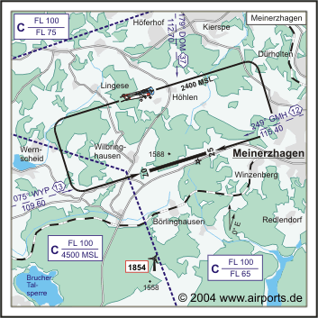
Frequenz Tower 130.600 EN/GE
NAV Aids ABN 076°/13 NM from WYP VOR 109.60 002°/19 NM from COL
VORTAC 108.80/Ch 25 251°/12 NM from GMH VOR 115.40
Koordinaten 51 06, 06 N / 07 35, 98 E
Platzrunde / Traffic circuit N/S 1300
Landebahnen / RWY 1
RWY 1170 x 20 m, ASPHALT / Antiskid
RWY 07 TKOF 820 m; LDG 1170 m
RWY 25 TKOF 1170 m; LDG 820 m
MTOW 5700 kg
Bemerkungen / Remarks Mast und Bäume (60 ft GND) Anflug 25 (500m
vor THR)/Mast and trees (60 ft GND) appoach sector 25 (500m from THR)
Restaurant Ja
Adresse
Steinsmark 2
ZIP / City D-58540 Meinerzhagen
Fon +49 (0)2354 / 902941
Fax 902343
info at flugplatz-meinerzhagen de
URL http://www.edkz.de
Images and information placed above are from http://www.airports.de/airport.php?ICAO=EDKZ
http://www.edkz.de
We thank them for the data!
| General Info
|
| Country |
Germany
|
| ICAO ID |
EDKZ
|
| Time |
UTC+1(+2DT)
|
| Latitude |
51.099444
51° 05' 58.00" N
|
| Longitude |
7.601944
007° 36' 07.00" E
|
| Elevation |
1548 feet
472 meters
|
| Magnetic Variation |
000° E (01/05)
|
| Beacon |
Yes
|
| Operating Agency |
PRIVATE
|
| Daylight Savings Time |
Last Sunday in March to last Sunday in October
|
| Communications
|
| INFO |
130.6
|
| LANGEN INFO |
129.875
|
| Runways
|
ID
|
Dimensions |
Surface |
PCN |
ILS
|
| 07/25 |
3839 x 66 feet
1170 x 20 meters |
ASPHALT |
- |
NO
|
| Supplies/Equipment
|
| Fuel |
Jet A1+, Jet A1 with icing inhibitor.
100/130 MIL Spec, low lead, aviation gasoline (BLUE)
|
| Remarks
|
| CAUTION |
Mast and trees 60' AGL 1640' fr thld Rwy 25.
|
| FUEL |
(NC-100LL, A1)
|
| MISC |
Fone C02354/902941.
|
| OPR HOURS |
Opr PPR 0900-1600Z Tue-Sun; (PPR 0800-1700Z Tue-Sun DT).
|
Runway 07/25
3839 x 66 feet
1170 x 20 meters
| Runway 07
|
| Surface |
ASPHALT
|
| True Heading |
073.0
|
| Latitude |
51.098803
51° 05' 55.69" N
|
| Longitude |
7.595167
007° 35' 42.60" E
|
| Landing Distance |
3839 feet
1170 meters
|
| Takeoff Distance |
3839 feet
1170 meters
|
| Runway 25
|
| Surface |
ASPHALT
|
| True Heading |
253.0
|
| Latitude |
51.101861
51° 06' 06.70" N
|
| Longitude |
7.610750
007° 36' 38.70" E
|
| Landing Distance |
2690 feet
820 meters
|
| Takeoff Distance |
3839 feet
1170 meters
|
| Displaced Threshold Length |
1149 feet
350 meters
|
The content above was published at Airports-Worldwide.com in 2005.
We don't guarantee the information is fresh and accurate. The data may be wrong or outdated.
For more up-to-date information please refer to other sources.
|


