|
 ICAO Code EDAM
Name MERSEBURG
Land Deutschland
Bundesland Sachsen-Anhalt
Letzte Änderung 30. Januar 2003
Kategorie Sonderlandeplatz / Special Airfield
Betreiber / Operator Merseburger Luftsportverein e. V.
Lage / Location W Merseburg
LFZ / ACFT Bis / up to 5700 kg, 14000 kg PPR,
Helicopter Ja / Yes
Motorsegler / GLDP Ja / Yes
Flugmodelle/Flying models PPR
Summer PPR
Winter PPR
O/T PPR
Luftaufsicht / OPS +49 (0)3461 / 723326, Fax 794831
PPR +49 (0)3461 / 794831
AIS EDDP +49 (0)69 / 78072614
MET (0190) 077226
Gafor 22
Zoll / Customs Nein / No
Fuel Nein / No
Oil PPR
Hangar Ja / Yes
Höhe / Elevation 340 ft / 104 m
FIS Berlin Information 125.800 Berlin Radar 124.175
Rufzeichen / Call sign Merseburg Info
Frequenz Tower 122.900 GE
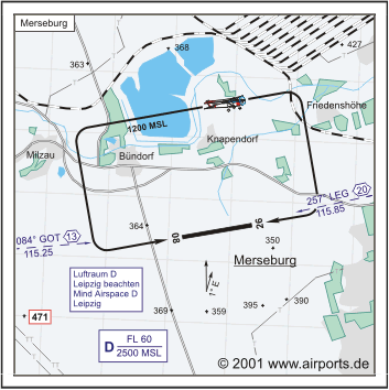
NAV Aids 084°/13 NM from GOT VOR/DME 115.25/Ch 99y 257°/20 NM
from LEG 115.85
Koordinaten 51 21, 78 N / 11 56, 45 E
Platzrunde / Traffic circuit N 1200
Landebahnen / RWY 1
RWY 1140 x 30 m, CONCRETE
RWY 08 TKOF 1140 m; LDG 1140 m
RWY 26 TKOF 1140 m; LDG 1140 m
MTOW 5700 kg, PPR 14000 kg
Bemerkungen / Remarks Airspace D Leipzig (2500 MSL/FL 60) Frequenz: 124.175!
Wohngebiete meiden!
Adresse
Postfach 1215
ZIP / City D-06202 Merseburg
URL: http://www.airports.de/airport.php?ICAO=EDAM
Images and information placed
above are from http://www.airports.de/airport.php?ICAO=EDAM
We thank them for the data!
| General Info
|
| Country |
Germany
|
| ICAO ID |
EDAM
|
| Time |
UTC+1(+2DT)
|
| Latitude |
51.363000
51° 21' 46.80" N
|
| Longitude |
11.940833
011° 56' 27.00" E
|
| Elevation |
340 feet
104 meters
|
| Magnetic Variation |
001° E (01/05)
|
| Operating Agency |
PRIVATE
|
| Daylight Savings Time |
Last Sunday in March to last Sunday in October
|
| Communications
|
| BERLIN RADAR |
124.175
|
| INFO |
122.9
|
| BERLIN INFO |
125.8
|
| Runways
|
ID
|
Dimensions |
Surface |
PCN |
ILS
|
| 08/26 |
3740 x 98 feet
1140 x 30 meters |
CONCRETE. |
- |
NO
|
| Remarks
|
| CAUTION |
PJE, gldr and unmanned acft act.
|
| RSTD |
PPR.
|
Runway 08/26
3740 x 98 feet
1140 x 30 meters
| Runway 08
|
| Surface |
CONCRETE.
|
| True Heading |
081.0
|
| Latitude |
51.362156
51° 21' 43.76" N
|
| Longitude |
11.932761
011° 55' 57.94" E
|
| Landing Distance |
3740 feet
1140 meters
|
| Takeoff Distance |
3740 feet
1140 meters
|
| Runway 26
|
| Surface |
CONCRETE.
|
| True Heading |
261.0
|
| Latitude |
51.363844
51° 21' 49.84" N
|
| Longitude |
11.948906
011° 56' 56.06" E
|
| Landing Distance |
3740 feet
1140 meters
|
| Takeoff Distance |
3740 feet
1140 meters
|
The content above was published at Airports-Worldwide.com in 2005.
We don't guarantee the information is fresh and accurate. The data may be wrong or outdated.
For more up-to-date information please refer to other sources.
|


