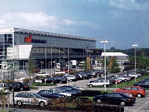
Münster Osnabrück International Airport |
 MÜNSTER OSNABRÜCK INTERNATIONAL AIRPORT: MÜNSTER OSNABRÜCK INTERNATIONAL AIRPORT:
Münster Osnabrück International Airport is one of the most
successful airports in Germany. Being located at the intersection of Western
Lower Saxony, the Northern Ruhr Area and the Netherlands, a good six million
people live in the immediate catchment area.
Further handling capacities, flight destinations, parking facilities
and further services are continuously added. The plans for an extension
of the runway are also making good progress so that intercontinental flights
will be possible in the next few years.
History
1966
On 21-12-1966 the towns of Münster, Osnabrück and Greven as
well as the counties of Münster, Tecklenburg and Steinfurt establish
"Flughafen Münster/Osnabrück GmbH".
1967
The first sod is turned for the construction of the airport on the fields
of Hüttrup Heath near Greven which have so far been used for agriculture
and forestry.
1968
On 24-09-1968 the Land North-Rhine-Westphalia approves the first construction
phase. The airfield and a runway with a length of 2000 m are completed.
Levelling of the ground is carried out by the British Army of the Rhine.
1972
After five years of construction Münster/Osnabrück Airport is
officially opened on 27-05-1972. Cimber Air takes off to Frankfurt/Main
three times a day with a 29-seater Nord 262. This was intended as a connecting
flight to one of Europe's largest hubs. In the first year of operation
a good 25,000 passengers are counted
1982
World-wide recession also shows its effects in air traffic. Scheduled
flights are drastically reduced due to low demand. Tour operators temporarily
move away to larger airports. The number of passengers drops to 80,000.
The Land NRW cancels subsidies. The operating loss rises to DM 3 million.
In this situation the people in charge even think about suspending flying
operations
 1992 1992
In the summer there are 150 scheduled flights and another 25 charter flights
per week. On 15th September green light is given: The Land NRW decides
to support the construction of the new terminal with DM 62 million from
structuring aid funds. Work starts immediately. In the same year the largest
growth jump in the history of the airport is accomplished with 100,000
additional passengers. Air Berlin takes off from FMO for the first time
2000
In April the new multi-storey car park P B is put into service. The topping-out
ceremony for the new terminal takes place in September. The project financed
by the airport itself costs approx. DM 100 million. For the extension
of the apron area another DM 15 million have to be provided. The new terminal
is supposed to be put into service in May/June 2001. With 1,774,739 passengers
and a rate of increase of 12.5% Münster/Osnabrück Airport is
once again the fastest growing airport in Germany in 2000. The airport
works out a new corporate identity. The guiding principle is "Relaxation
for the air passenger."
2002
Air Berlin intensifies its engagement at Münster/Osnabrück Airport
and plans to build a new aircraft maintenance hangar. The planned size
of this hangar is approx. 45 x 50 m with a headroom of 13.50 m where aircraft,
type Boeing 737-800 and also larger variants of this model can be serviced.
Air Berlin and the airport intend to put the new maintenance hangar into
service in 2003. It will be located east of the fire-brigade building.
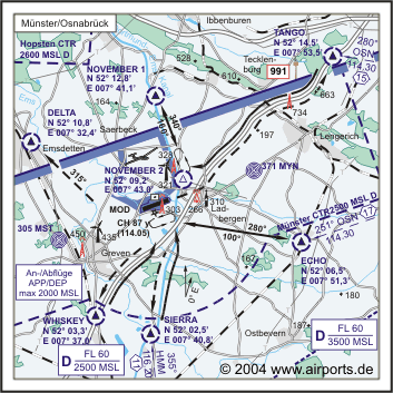
ICAO Code EDDG
IATA Code FMO
Name MÜNSTER - Osnabrück
Land Deutschland
Bundesland Nordrhein-Westfalen
Letzte Änderung 23. Juli 2003
Kategorie Int. Verkehrsflughafen / Int. Airport
Betreiber / Operator Flughafen Münster/Osnabrück GmbH
Lage / Location 3.7 NM NE Greven, 13 NM N Münster, 15 NM SW Osnabrück
Nachtflug / NVFR NVFR
Instrumentenflug / IFR IFR
LFZ / ACFT Bis / up to PCN 68 V/B/X/T
Helicopter Ja / Yes
Motorsegler / GLDP Ja / Yes
Segelflugzeuge / GLD Ja / Yes
Luftschiffe/Airships
Summer H 24, CTR H 24
Winter H 24, CTR H 24
Luftaufsicht / OPS +49 (0)2571 / 91333, 943870, Fax 921029, Luftaufsicht,
Verkehrszentrale +49 (0)2571/ 943340, Fax 943349, Telex SITA FMOAPXH
AIS AIS-Centre EDDZ, +49 (0)69 / 78072500
ACC EDDL +49 (0)6103 / 7076600 / 6601
MET (0190) 077223
Gafor 32
Zoll / Customs H 24
Fuel 100 LL, Jet A1
Oil EE 80, EE 100, 20W50, AVOIL 100
Hangar O / R
Höhe / Elevation 159 ft / 48 m
FIS Langen Information 129.875Münster-Osnabrück ATIS 127.175
VDF / QDM O/R
Rufzeichen / Call sign Münster Tower/Turm
Frequenz Tower 129.800 EN/GE
Frequenz Ground 121.875 EN/GE
NAV Aids ABN PAPI DME MOD 114.05 am Platz/at field ILS RWY 25 110.10 ILS
RWY 07 111.90
Koordinaten 52 08, 08 N / 07 41, 09 E
Landebahnen / RWY 1
RWY 2170 x 45 m, ASPHALT
RWY 07 TKOF 2170 m; LDG 2170 m
RWY 25 TKOF 2170 m; LDG 1970 m
MTOW PCN 68 F/B/X/T
Restaurant Ja
Adresse
Hüttrupper Heide 71-81
ZIP / City D-48268 Greven
Fon +49 (0)2571 / 940
URL http://www.fmo.de
eMail info at fmo de
Images and information placed
above are from http://www.airports.de/airport.php?ICAO=EDDG
http://www.fmo.de
We thank them for the data!
| General Info
|
| Country |
Germany
|
| ICAO ID |
EDDG
|
| Time |
UTC+1(+2DT)
|
| Latitude |
52.134642
52° 08' 04.71" N
|
| Longitude |
7.684831
007° 41' 05.39" E
|
| Elevation |
160 feet
49 meters
|
| Type |
Civil
|
| Magnetic Variation |
000° E (01/05)
|
| Beacon |
Yes
|
| Operating Agency |
CIVIL GOVERNMENT, (LANDING FEES AND DIPLOMATIC CLEARANCE MAY BE REQUIRED)
|
| Near City |
Osnabruck
|
| Daylight Savings Time |
Last Sunday in March to last Sunday in October
|
| Communications
|
| TWR |
129.8
369.9
|
| LANGEN RADAR |
129.3
242.2
|
GND
Opr 0430-1930Z++.
|
121.875
369.9
|
ATIS
Opr 0520-2050Z++.
|
127.175
|
| LANGEN INFO |
129.875
|
| Runways
|
ID
|
Dimensions |
Surface |
PCN |
ILS
|
| 07/25 |
7119 x 148 feet
2170 x 45 meters |
ASPHALT |
068FBXT |
YES
|
| Navaids
|
| Type |
ID |
Name |
Channel |
Freq |
Distance From Field |
Bearing From Navaid
|
| NDB |
MYN |
MUNSTER |
- |
371 |
4.5 NM |
250.9
|
| DME |
MOD |
MUNSTER |
087Y |
- |
At Field |
-
|
| Supplies/Equipment
|
| Fuel |
Jet A1, without icing nhibitor.
100/130 MIL Spec, low lead, aviation gasoline (BLUE)
|
| Oil |
Available (Types unknown)
|
| Remarks
|
| CAUTION |
Bird haz.
|
| CSTMS/IMG |
Avbl.
|
| FUEL |
Avbl 0400-2200Z++ Sat, Sun. OT 30 min PN. (NC-100LL, A1)
|
| LGT |
PAPI Rwy 07 MEHT 50', PAPI Rwy 25 MEHT 51'.
|
| MISC |
Gldr act N of arpt. Arpt fone C02571-91333.
|
| RSTD |
Avoid ovft of towns Ladbergen and Greven. IAP unavbl 2200-0500Z++.
|
Runway 07/25
7119 x 148 feet
2170 x 45 meters
| Runway 07
|
| Surface |
ASPHALT
|
| True Heading |
071.0
|
| Latitude |
52.131511
52° 07' 53.44" N
|
| Longitude |
7.670058
007° 40' 12.21" E
|
| Elevation |
156.0 feet
48 meters
|
| Slope |
0.0°
|
| Landing Distance |
7119 feet
2170 meters
|
| Takeoff Distance |
7119 feet
2170 meters
|
| Lighting System |
SF
CL
HIRL
T
PAPI |
| Runway 25
|
| Surface |
ASPHALT
|
| True Heading |
251.0
|
| Latitude |
52.137858
52° 08' 16.29" N
|
| Longitude |
7.700022
007° 42' 00.08" E
|
| Elevation |
159.0 feet
48 meters
|
| Slope |
0.0°
|
| Landing Distance |
6463 feet
1970 meters
|
| Takeoff Distance |
7316 feet
2230 meters
|
| Displaced Threshold Length |
656 feet
200 meters
|
| Overrun Length |
197 feet
60 meters
|
| Overrun Surface |
GRASS OR EARTH NOT GRADED OR ROLLED.
|
| Lighting System |
SF
TDZL
CL
HIRL
REIL
A1
PAPI |
Navaids
| MUNSTER
|
| Type |
ID |
Channel |
Freq |
Country |
State
|
| NDB |
MYN |
- |
371 |
Germany |
-
|
| Latitude |
Longitude |
Airport
|
52.159328
52° 09' 33.58" N |
7.799994
007° 47' 59.98" E |
EDDG |
Navaids
| MUNSTER
|
| Type |
ID |
Channel |
Freq |
Country |
State
|
| DME |
MOD |
087Y |
- |
Germany |
-
|
| Latitude |
Longitude |
Airport
|
52.137969
52° 08' 16.69" N |
7.687242
007° 41' 14.07" E |
EDDG |
The content above was published at Airports-Worldwide.com in 2005.
We don't guarantee the information is fresh and accurate. The data may be wrong or outdated.
For more up-to-date information please refer to other sources.
|


