 |
|
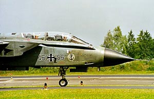
German airforce fighter base
Location - 3 km SE Neuburg
 Photographer - Gerhard Plomitzer
| General Info
|
| Country |
Germany
|
| ICAO ID |
ETSN
|
| Time |
UTC+1(+2DT)
|
| Latitude |
48.711000
48° 42' 39.60" N
|
| Longitude |
11.211500
011° 12' 41.40" E
|
| Elevation |
1249 feet
381 meters
|
| Type |
Civil
|
| Magnetic Variation |
001° E (04/05)
|
| Beacon |
Yes
|
| Operating Agency |
GERMAN AIR FORCE
|
| Operating Hours |
SEE REMARKS FOR OPERATING HOURS OR COMMUNICATIONS FOR POSSIBLE HOURS
|
| International Clearance Status |
Airport of Entry
|
| Daylight Savings Time |
Last Sunday in March to last Sunday in October
|
| Communications
|
| DONAU TWR |
122.1
129.85
138.15
257.8
269.7
|
| DONAU RADAR |
123.3
130.15
138.8
139.15
275.4
|
| MUNCHEN RADAR |
136.525
371.7
|
| Runways
|
ID
|
Dimensions |
Surface |
PCN |
ILS
|
| 09/27 |
8005 x 98 feet
2440 x 30 meters |
ASPHALT |
- |
NO
|
| Navaids
|
| Type |
ID |
Name |
Channel |
Freq |
Distance From Field |
Bearing From Navaid
|
| TACAN |
NEU |
NEUBURG |
026X |
- |
At Field |
-
|
| Supplies/Equipment
|
| Fuel |
JP-8, SemiKeroscene MIL Spec T-83133, without icing inhibitor
|
| Oil |
O-133, 1010, jet Engine Oil (MIL l 6081)
O-148, MIL L 7808 (Synthetic Base), Turboprop/Turboshaft Engine
O-156, MIL L 23699 (Synthetic Base)Turboprop/Turboshaft Engine
|
| Other Fluids |
LOX, Liquid oxygen servicing
OX, Indicates oxygen servicing when type of servicing is unknown
|
| JASU |
RST-180
75kva AC 115/200v 400hz AIR 145-155lb/min at 47-51 psi
|
| Remarks
|
| A-GEAR |
Rwy 09 HOOK 44B-2D (1503') O/R 10 min. Rwy 27 HOOK 44B-2D (1300') O/R 10 min.
|
| CAUTION |
Gldr act 0900Z++-SS Sat, SR-SS Sun and hol to 3000' 3 NM rad of arpt in VMC only. Exp apch dly.
|
| FLUID |
LOX
|
| FUEL |
J8
|
| JASU |
A(GPE-160/180) 1(RST-180)
|
| MISC |
Cross svcg ltd Mon-Thu aft 1600Z++ and Fri aft 1100Z++. Touch and go ldg or lo apch allowed only once aft 1600Z++. Rwy ldg sfc has anti-skid layer. Fone C08431-643-0 extn 2722. R/W reful only at R/W ldg area SE of rwy cntr.
|
| OIL |
O-133-148-156
|
| OPR HOURS |
Opr 0700-1600Z++ Mon-Thu, 0700-1100Z++ Fri, clsd hol.
|
| RSTD |
PPR 48 hr PN. No practice apch btn 1130-1300Z++.
|
Runway 09/27
8005 x 98 feet
2440 x 30 meters
| Runway 09
|
| Surface |
ASPHALT
|
| True Heading |
091.0
|
| Latitude |
48.711167
48° 42' 40.20" N
|
| Longitude |
11.195000
011° 11' 42.00" E
|
| Elevation |
1249.0 feet
381 meters
|
| Slope |
0.0°
|
| Landing Distance |
8005 feet
2440 meters
|
| Takeoff Distance |
8956 feet
2730 meters
|
| Overrun Length |
951 feet
290 meters
|
| Overrun Surface |
PART CONCRETE, PART ASPHALT, OR PART BITUMEN-BOUND MACADAM.
|
| Lighting System |
SF
HIRL
REIL
J
PAPI |
| Runway 27
|
| Surface |
ASPHALT
|
| True Heading |
271.0
|
| Latitude |
48.710833
48° 42' 39.00" N
|
| Longitude |
11.228167
011° 13' 41.40" E
|
| Elevation |
1245.0 feet
379 meters
|
| Slope |
0.0°
|
| Landing Distance |
8005 feet
2440 meters
|
| Takeoff Distance |
8907 feet
2715 meters
|
| Overrun Length |
902 feet
275 meters
|
| Overrun Surface |
PART CONCRETE, PART ASPHALT, OR PART BITUMEN-BOUND MACADAM.
|
| Lighting System |
SF
HIRL
REIL
J
PAPI |
Navaids
| NEUBURG
|
| Type |
ID |
Channel |
Freq |
Country |
State
|
| TACAN |
NEU |
026X |
- |
Germany |
-
|
| Latitude |
Longitude |
Airport
|
48.712500
48° 42' 45.00" N |
11.211000
011° 12' 39.60" E |
ETSN |
The content above was published at Airports-Worldwide.com in 2005.
We don't guarantee the information is fresh and accurate. The data may be wrong or outdated.
For more up-to-date information please refer to other sources.
|
|


