|
ICAO Code EDON
Name NEUHARDENBERG
Land Deutschland
Bundesland Brandenburg
Letzte Änderung 14. August 2004
 Kategorie
Sonderlandeplatz / Special Airfield Kategorie
Sonderlandeplatz / Special Airfield
Betreiber / Operator Airport Berlin-Neuhardenberg GmbH
Lage / Location 1 NM N Neuhardenberg
Nachtflug / NVFR Nein/No
Instrumentenflug / IFR Nein/No
LFZ / ACFT Bis / up to PCN 53 R/B/W/T bis Spannweite/up to wing span 24
m
Helicopter Ja/Yes
Motorsegler / GLDP Ja/Yes
Segelflugzeuge / GLD Ja/Yes
Ballone Ja/Yes
UL Ja/Yes
Fallschirmspringen / PJE Ja/Yes
Luftschiffe/airships, Luftsportgeräte/flying sports products
Summer PPR
Winter PPR
O/T PPR
Luftaufsicht / OPS +49 (0)33476 / 60480, Fax 604821
PPR +49 (0)33476 / 60480, Fax 604821
AIS EDDB +49 (0)30 / 60918250
MET 0190 077222
Gafor 18
Fuel Nein/No
Oil Nein/No
Hangar begrenzt/limited
Höhe / Elevation 35 ft / 12 m
FIS Berlin Information 126.350
Rufzeichen / Call sign Neuhardenberg Info
Frequenz Tower 126.350 GE
NAV Aids 017°/13 NM from FWE 113.30 316°/19NM from SUI 116.70
Koordinaten 52 36, 78 N / 14 14, 56 E
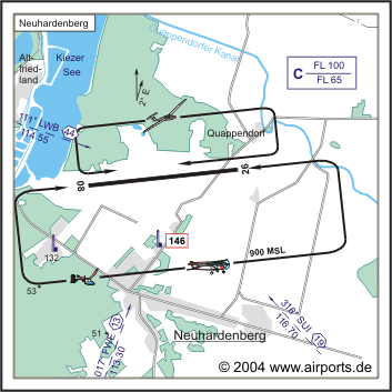
Platzrunde / Traffic circuit S 900
Landebahnen / RWY 1
RWY 2400 x 50 m, Concrete
RWY 08 TKOF 2400 m; LDG 2400 m
RWY 26 TKOF 2400 m; LDG 2400 m
MTOW PCN 53 R/B/W/T
Adresse
Oderbruchstr. 24 a
ZIP / City D-15320 Neuhardenberg
Fon +49 (0)33476 / 60480
Fax 604821
URL: http://www.airports.de/airport.php?ICAO=EDON
Images and information placed
above are from http://www.airports.de/airport.php?ICAO=EDON
We thank them for the data!
| General Info
|
| Country |
Germany
|
| ICAO ID |
EDON
|
| Time |
UTC+1(+2DT)
|
| Latitude |
52.613000
52° 36' 46.80" N
|
| Longitude |
14.242667
014° 14' 33.60" E
|
| Elevation |
35 feet
11 meters
|
| Magnetic Variation |
002° E (01/05)
|
| Operating Agency |
PRIVATE
|
| Alternate Name |
WRIEZEN
|
| Operating Hours |
SEE REMARKS FOR OPERATING HOURS OR COMMUNICATIONS FOR POSSIBLE HOURS
|
| Daylight Savings Time |
Last Sunday in March to last Sunday in October
|
| Communications
|
| INFO |
119.125
|
| BERLIN INFO |
126.35
|
| Runways
|
ID
|
Dimensions |
Surface |
PCN |
ILS
|
| 08/26 |
7874 x 164 feet
2400 x 50 meters |
CONCRETE. |
053RBWT |
NO
|
| Supplies/Equipment
|
| Fuel |
Unknown fuel type or whether there is any fuel.
|
| Remarks
|
| OPR HOURS |
Opr PPR
|
Runway 08/26
7874 x 164 feet
2400 x 50 meters
| Runway 08
|
| Surface |
CONCRETE.
|
| True Heading |
082.0
|
| Latitude |
52.611497
52° 36' 41.39" N
|
| Longitude |
14.225125
014° 13' 30.45" E
|
| Landing Distance |
7874 feet
2400 meters
|
| Takeoff Distance |
7874 feet
2400 meters
|
| Runway 26
|
| Surface |
CONCRETE.
|
| True Heading |
262.0
|
| Latitude |
52.614494
52° 36' 52.18" N
|
| Longitude |
14.260211
014° 15' 36.76" E
|
| Landing Distance |
7874 feet
2400 meters
|
| Takeoff Distance |
7874 feet
2400 meters
|
The content above was published at Airports-Worldwide.com in 2005.
We don't guarantee the information is fresh and accurate. The data may be wrong or outdated.
For more up-to-date information please refer to other sources.
|


