 |
|
Neuhausen Ob Eck Airfield |
ICAO Code EDSN
Name NEUHAUSEN OB ECK
Land Deutschland
Bundesland Baden-Württemberg
Letzte Änderung 23. Juli 2003
 Kategorie
Sonderlandeplatz / Special Airfield Kategorie
Sonderlandeplatz / Special Airfield
Betreiber / Operator take-off Gewerbepark Betreibergesellschaft mbH
Lage / Location 3,5 NM E Tuttlingen
Nachtflug / NVFR NVFR
LFZ / ACFT Bis / up to 5700 kg
Helicopter Ja / Yes
Motorsegler / GLDP Ja / Yes
UL Ja / Yes
Summer Mon-Fri 0700-SS+30/1600
Winter Mon-Fri 0800-SS+30/1700
O/T PPR
Luftaufsicht / OPS +49 (0)7467 / 949030 Fax 949031
PPR +49 (0)7467 / 949030 Fax 949031
AIS AIS-Centre EDDZ, +49 (0)69 / 78072500
ACC EDDF +49 (0)6103 / 7076200
APP LSZH +41 18163908
MET (0190) 077227
Gafor 62
Zoll / Customs Nein / No
Fuel Avgas 100LL, Jet A1
Oil Nein / No
Hangar Ja/Yes
Höhe / Elevation 2648 ft / 804 m
FIS Zürich Information 127.700
Rufzeichen / Call sign Neuhausen ob Eck Info
Frequenz Tower 130.500 GE
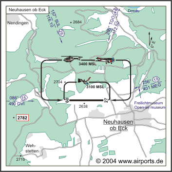
NAV Aids 157°/26 NM from SUL 116.10 200°/41 NM from TGO 112.50
256°/19 NM from MEG 401 086°/15NM from DVI 490
Koordinaten 47 58, 61 N / 08 54, 31 E
Platzrunde / Traffic circuit N 3400
Landebahnen / RWY 1
RWY 1248 x 30 m, ASPHALT
RWY 09 TKOF 1248 m; LDG 1248 m
RWY 27 TKOF 1248 m; LDG 1248 m
MTOW 20000 kg
Bemerkungen / Remarks Wohngebiete meiden
Restaurant Ja
Adresse
Haus 5
ZIP / City D-79579
Neuhausen ob Eck
Fon +49 (0)7467 / 94900
Fax 949019
URL: http://www.airports.de/airport.php?ICAO=EDSN
Images and information placed
above are from http://www.airports.de/airport.php?ICAO=EDSN
We thank them for the data!
| General Info
|
| Country |
Germany
|
| ICAO ID |
EDSN
|
| Time |
UTC+1(+2DT)
|
| Latitude |
47.976569
47° 58' 35.65" N
|
| Longitude |
8.903931
008° 54' 14.15" E
|
| Elevation |
2648 feet
807 meters
|
| Magnetic Variation |
000° E (01/05)
|
| Operating Agency |
PRIVATE
|
| Daylight Savings Time |
Last Sunday in March to last Sunday in October
|
| Communications
|
| INFO |
130.5
|
| ZURICH INFO |
124.7
|
| Runways
|
ID
|
Dimensions |
Surface |
PCN |
ILS
|
| 09/27 |
4094 x 98 feet
1248 x 30 meters |
ASPHALT |
- |
NO
|
| Supplies/Equipment
|
| Fuel |
Jet A1, without icing nhibitor.
100/130 MIL Spec, low lead, aviation gasoline (BLUE)
|
| Remarks
|
| CAUTION |
Self-launching gldr act.
|
| FUEL |
(NC-100LL, A1)
|
| OPR HOURS |
Opr 0700-SS+30/1600Z++, 0300-0700Z++ and 1600-2000Z++ PPR, Mon-Fri, O/T 2hr PPR.
|
Runway 09/27
4094 x 98 feet
1248 x 30 meters
| Runway 09
|
| Surface |
ASPHALT
|
| True Heading |
091.0
|
| Latitude |
47.976889
47° 58' 36.80" N
|
| Longitude |
8.896811
008° 53' 48.52" E
|
| Elevation |
2648.0 feet
807 meters
|
| Slope |
-1.1°
|
| Landing Distance |
4094 feet
1248 meters
|
| Takeoff Distance |
4291 feet
1308 meters
|
| Overrun Length |
197 feet
60 meters
|
| Overrun Surface |
ASPHALT
|
| Runway 27
|
| Surface |
ASPHALT
|
| True Heading |
271.0
|
| Latitude |
47.976778
47° 58' 36.40" N
|
| Longitude |
8.913522
008° 54' 48.68" E
|
| Elevation |
2601.0 feet
793 meters
|
| Slope |
1.1°
|
| Landing Distance |
4094 feet
1248 meters
|
| Takeoff Distance |
4291 feet
1308 meters
|
| Overrun Length |
197 feet
60 meters
|
| Overrun Surface |
ASPHALT
|
The content above was published at Airports-Worldwide.com in 2005.
We don't guarantee the information is fresh and accurate. The data may be wrong or outdated.
For more up-to-date information please refer to other sources.
|
|


