Nürnberg International Airport |
 Nuremberg
International Airport operated sucessfully during the first half of the
2005 financial year, having handled almost 2 million passengers; representing
a 6.5 % increase over the same period last year. In response the 2005/2006
winter schedules have also been prepared to take continued growth into
account, and cover popular some new low-cost routes, with Milan at the
top of the list. Nuremberg
International Airport operated sucessfully during the first half of the
2005 financial year, having handled almost 2 million passengers; representing
a 6.5 % increase over the same period last year. In response the 2005/2006
winter schedules have also been prepared to take continued growth into
account, and cover popular some new low-cost routes, with Milan at the
top of the list.
The Flughafen Nürnberg GmbH is concerned with the
operation and maintenance of the passenger terminal, runway system and
the hiring and letting of buildings, rooms and facilities to our partners
at the airport.
The Flughafen Nürnberg Service GmbH is responsible for the provision
and management of public shops, duty free sales and passenger car parks.
 The AirPart GmbH offers ground handling services. These include aircraft
handling (loading and unloading aircraft, baggage sorting, transport services,
interior cleaning of aircraft), passenger handling (passenger check-in,
ticketing, operations services and lost & found) and cargo handling
(handling import and export cargo). The AirPart GmbH offers ground handling services. These include aircraft
handling (loading and unloading aircraft, baggage sorting, transport services,
interior cleaning of aircraft), passenger handling (passenger check-in,
ticketing, operations services and lost & found) and cargo handling
(handling import and export cargo).
History:
Nuremberg International Airport was opened between the fields of the
Nuremberg "Knoblauchland" area in April 1955 and has developed
into one of the key infrastructure organizations in North Bavaria and
an important aviation hub at the heart of a growing Europe.
Nuremberg airport with around 3.3 million passengers is now approaching
its Jubilee Year 2005, which is to be celebrated with parties, shows and
other events.
 ICAO
Code EDDN ICAO
Code EDDN
IATA Code NUE
Name NÜRNBERG
Land Deutschland
Bundesland Bayern
Letzte Änderung 8. Dezember 2004
Kategorie Int. Verkehrsflughafen / Int. Airport
Betreiber / Operator Flughafen Nürnberg GmbH
Lage / Location 2.7 NM Stadtmitte/Centre of Nürnberg
Nachtflug / NVFR NVFR
Instrumentenflug / IFR IFR
LFZ / ACFT Bis / up to PCN 65 R/B/W/T (932 m) PCN 65 F/A/X/T (1768 m)
Helicopter Ja / Yes
PPR für alle Schulungs- und Übungsflüge (VFR Nachtflüge)/PPR
for all training and exercise flights (VFR night flights)Tel. 06103 /
7076200, VFR Nacht Platzrundenflüge 0911 36059145
Summer H 24, CTR H 24
Winter H 24, CTR H 24
Luftaufsicht / OPS +49 (0)911 / 3506576
AIS AIS-Centre EDDZ, +49 (0)69 / 78072500
APP EDDN +49 (0)89 / 9780330
MET (0190) 077225
Gafor 55
Zoll / Customs JA/YES
Fuel 100 LL, Jet A1 MON-SAT 0530-2130 (0430-2030) SUN 0530-2000 (0430-1900)
Oil 80, 100, D 80, D 100
Hangar O / R
Höhe / Elevation 1046 ft / 319 m
FIS Langen Information 127.975
VDF / QDM O/R
Rufzeichen / Call sign Nürnberg Tower/Turm
Frequenz Tower 118.300 EN/GE
Frequenz Ground 118.100
NAV Aids ABN PAPI DME NGD 113.10 am Platz/at field ILS RWY 28 109.10 ILS
RWY 10 111.30
Koordinaten 49 29, 92 N / 11 04, 69 E
Landebahnen / RWY 1
RWY 2700 x 45 m, ASPHALT / CONCRETE
RWY 10 TKOF 2700 m; LDG 2700 m
RWY 28 TKOF 2700 m; LDG 2700 m
MTOW 65 R/B/W/T, 65 F/A/X/T
Restaurant Ja
Adresse
Flughafenstr. 100
ZIP / City D-90411
Nürnberg
Fon +49 (0)911 / 9371576
Fax 911 / 9371579
E-mail: info at airport-nuernberg de
URL http://www.flughafen-nuernberg.de
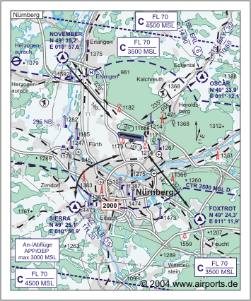
Images and information placed
above are from http://www.flughafen-nuernberg.de
http://www.airports.de/airport.php?ICAO=EDDN
We thank them for the data!
| General Info
|
| Country |
Germany
|
| ICAO ID |
EDDN
|
| Time |
UTC+1(+2DT)
|
| Latitude |
49.498644
49° 29' 55.12" N
|
| Longitude |
11.078106
011° 04' 41.18" E
|
| Elevation |
1046 feet
319 meters
|
| Type |
Civil
|
| Magnetic Variation |
001° E (01/05)
|
| Beacon |
Yes
|
| Operating Agency |
CIVIL GOVERNMENT, (LANDING FEES AND DIPLOMATIC CLEARANCE MAY BE REQUIRED)
|
| International Clearance Status |
Airport of Entry
|
| Daylight Savings Time |
Last Sunday in March to last Sunday in October
|
| Communications
|
| TWR |
118.3
337.75
|
| MUNCHEN RADAR |
118.975
344.5
|
| GND |
118.1
|
| DIR |
119.475
|
ATIS
Opr 0420-2250Z++.
|
123.075
|
| LANGEN INFO |
127.975
277.6
FIS-(127.975 TMA)
|
| Runways
|
ID
|
Dimensions |
Surface |
PCN |
ILS
|
| 10/28 |
8858 x 148 feet
2700 x 45 meters |
ASPHALT |
065FAXT |
YES
|
| Navaids
|
| Type |
ID |
Name |
Channel |
Freq |
Distance From Field |
Bearing From Navaid
|
| NDB |
RTB |
ROTHENBACH |
- |
415 |
6.9 NM |
278.0
|
| DME |
NGD |
NURNBERG |
078X |
- |
At Field |
-
|
| Supplies/Equipment
|
| Fuel |
Jet A1, without icing nhibitor.
100/130 MIL Spec, low lead, aviation gasoline (BLUE)
|
| Remarks
|
| CAUTION |
Twy F clsd tkof and ldg, exc copter.
|
| FUEL |
Opr 0400Z++ Mon-2300Z++ Sat, 0400-2300Z++ Sun. OT O/R 30 min. (NC-100LL, A1)
|
| LGT |
PAPI Rwy 10 MEHT 52', PAPI Rwy 28 MEHT 55'.
|
| MISC |
Fst 3058' Rwy 10 conc.
|
| RSTD |
PPR for all trng and exer flt (IFR and VFR ngt flt), ctc DFS watch supervisor atC(49)(0)89-9780330.
|
Runway 10/28
8858 x 148 feet
2700 x 45 meters
| Runway 10
|
| Surface |
ASPHALT
|
| True Heading |
099.0
|
| Latitude |
49.500550
49° 30' 01.98" N
|
| Longitude |
11.059169
011° 03' 33.01" E
|
| Elevation |
1022.0 feet
312 meters
|
| Slope |
0.3°
|
| Landing Distance |
8858 feet
2700 meters
|
| Takeoff Distance |
8858 feet
2700 meters
|
| Lighting System |
SF
HIRL
REIL
A1
PAPI
PORTABLE |
| Runway 28
|
| Surface |
ASPHALT
|
| True Heading |
279.0
|
| Latitude |
49.496925
49° 29' 48.93" N
|
| Longitude |
11.096025
011° 05' 45.69" E
|
| Elevation |
1046.0 feet
319 meters
|
| Slope |
-0.3°
|
| Landing Distance |
8858 feet
2700 meters
|
| Takeoff Distance |
8858 feet
2700 meters
|
| Lighting System |
SF
TDZL
CL
HIRL
REIL
A
PAPI
PORTABLE |
Navaids
| ROTHENBACH
|
| Type |
ID |
Channel |
Freq |
Country |
State
|
| NDB |
RTB |
- |
415 |
Germany |
-
|
| Latitude |
Longitude |
Airport
|
49.482689
49° 28' 57.68" N |
11.252861
011° 15' 10.30" E |
EDDN |
Navaids
| NURNBERG
|
| Type |
ID |
Channel |
Freq |
Country |
State
|
| DME |
NGD |
078X |
- |
Germany |
-
|
| Latitude |
Longitude |
Airport
|
49.501158
49° 30' 04.17" N |
11.080150
011° 04' 48.54" E |
EDDN |
The content above was published at Airports-Worldwide.com in 2005.
We don't guarantee the information is fresh and accurate. The data may be wrong or outdated.
For more up-to-date information please refer to other sources.
|


