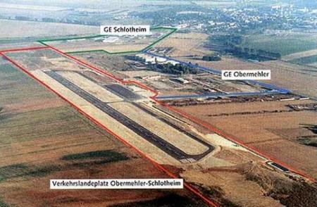
Obermehler Schlotheim Airfield |
ICAO Code EDCO
Name OBERMEHLER - Schlotheim
Land Deutschland
Bundesland Thüringen
Letzte Änderung 7. März 2002
Kategorie Verkehrslandeplatz / Public Airfield
Betreiber / Operator Flugplatz Obermehler GmbH
Lage / Location 10 NM NE Mühlhausen
LFZ / ACFT Bis / up to 14000 kg
Helicopter Ja / Yes
Fallschirmspringen / PJE Ja / Yes
Summer PPR
Winter PPR
O/T PPR
Luftaufsicht / OPS =AE282+49 (0)36021 / 94979, 0172 / 3619956, Fax 94981
PPR +49 (0)36021 / 94979, 0172 / 3619956, Fax 94981
AIS EDDB +49 (0)30 / 60918250
MET (0190) 077226
Gafor 24
 Zoll
/ Customs Nein / No Zoll
/ Customs Nein / No
Fuel 100 LL, Jet A1
Oil 20W50
Hangar Ja / Yes
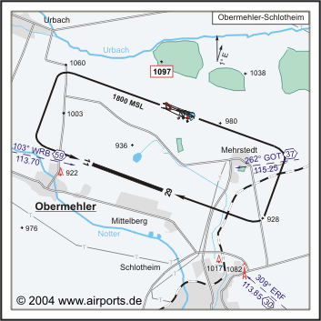
Höhe / Elevation 909 ft / 277 m
FIS Berlin Information 125.800
Rufzeichen / Call sign Obermehler Info
Frequenz Tower 122.900 GE
NAV Aids 103°/59 NM from WRB 113.70 263°/37 NM from GOT 115.25
310°/30 NM from ERF 113.85
Koordinaten 51 16, 06 N / 10 38, 09 E
Platzrunde / Traffic circuit N 1800
Landebahnen / RWY 1
RWY 1450 x 30 m, ASPHALT
RWY 11 TKOF 1450 m; LDG 1450 m
RWY 29 TKOF 1450 m; LDG 1450 m
MTOW 14000 kg
Bemerkungen / Remarks Wohngebiete meiden!
Address:
ZIP / City D-99996
Obermehler
Fon +49 (0)36021 / 94979, 94980
Fax 94981
URL http://www.obermehler.de
eMail flugplatz at obermehler de
Images and information placed
above are from http://www.obermehler.de
http://www.airports.de/airport.php?ICAO=EDCO
http://www.landkreis-unstrut-hainich.de/wirtschaft/flugplatz.htm
We thank them for the data!
| General Info
|
| Country |
Germany
|
| ICAO ID |
EDCO
|
| Time |
UTC+1(+2DT)
|
| Latitude |
51.267667
51° 16' 03.60" N
|
| Longitude |
10.634833
010° 38' 05.40" E
|
| Elevation |
909 feet
277 meters
|
| Magnetic Variation |
001° E (01/05)
|
| Operating Agency |
CIVIL GOVERNMENT, (LANDING FEES AND DIPLOMATIC CLEARANCE MAY BE REQUIRED)
|
| Alternate Name |
SCHLOTHEIM
|
| Operating Hours |
SEE REMARKS FOR OPERATING HOURS OR COMMUNICATIONS FOR POSSIBLE HOURS
|
| Daylight Savings Time |
Last Sunday in March to last Sunday in October
|
| Communications
|
| INFO |
122.9
|
BERLIN INFO
H24
|
125.8
375.325
|
| Runways
|
ID
|
Dimensions |
Surface |
PCN |
ILS
|
| 11/29 |
4757 x 98 feet
1450 x 30 meters |
ASPHALT |
- |
NO
|
| Supplies/Equipment
|
| Fuel |
Jet A1, without icing nhibitor.
100/130 MIL Spec, low lead, aviation gasoline (BLUE)
|
| Remarks
|
| FUEL |
(NC-100LL, A1)
|
| OPR HOURS |
Opr PPR
|
Runway 11/29
4757 x 98 feet
1450 x 30 meters
| Runway 11
|
| Surface |
ASPHALT
|
| True Heading |
110.0
|
| Latitude |
51.269864
51° 16' 11.51" N
|
| Longitude |
10.625053
010° 37' 30.19" E
|
| Landing Distance |
4757 feet
1450 meters
|
| Takeoff Distance |
4757 feet
1450 meters
|
| Runway 29
|
| Surface |
ASPHALT
|
| True Heading |
290.0
|
| Latitude |
51.265469
51° 15' 55.69" N
|
| Longitude |
10.644611
010° 38' 40.60" E
|
| Landing Distance |
4757 feet
1450 meters
|
| Takeoff Distance |
4757 feet
1450 meters
|
The content above was published at Airports-Worldwide.com in 2005.
We don't guarantee the information is fresh and accurate. The data may be wrong or outdated.
For more up-to-date information please refer to other sources.
|


