|
Rechlin is a small village in Mecklenburg-Vorpommern,
Germany. The town's airport was the Luftwaffe's main testing ground for
new aircraft designs during the Third Reich. The Rechlin data sheets on
Luftwaffe and captured Allied aircraft are considered by many aviation
historians to be among the most reliable sources for aircraft performance
data from the WW2 era.
The beginnings
Construction of the first airfield at Rechlin started in 1916; the airfield
was officially opened on 29 August, 1918. After the end of World War 1,
the airfield was closed again and many of its installations dismantled.
During the 1920s, the airfield was reopened as a civilian airbase, but
it was soon used as a testing ground for the secret German air force experiments
under the Treaty of Rapallo. The site was probably chosen for its remote
location in an almost uninhabited area.
During the Third Reich
In 1935, the Rechlin airfield became the official testing ground of the
newly-formed Luftwaffe. The site was designated Erprobungsstelle (E-Stelle)
and was expanded by constructing two more airfileds in nearby Roggenthin
and Lärz. Construction work on the airfields and the accompanying
barracks was partly carried out by forced labor from nearby concentration
camp Ravensbr?ck.
Many of the Luftwaffe's new plane models were test flown at the Rechlin
facilities; KG 200 with its array of captured planes was a regular guest
at the airfields. After several Allied bombing runs on the Rechlin and
Roggenthin airfields in 1944, testing of late-war planes was shifted to
Lärz. On April 10, 1945, a final bomber attack by the US Air Force
almost completely destroyed the airfields; what was left was blown up
by the German garrison before Soviet troops arrived at Rechlin on May
2.
Post-war history
In 1946, the Soviet Air Force established a permanent presence at the
airbase. An attack fighter squadron and later a helicopter squadron were
stationed at Lärz; the airfield at Rechlin was used by the NVA. Military
usage of the airfields continued until 1993, when the last Russian air
force units were moved home. The Rechlin airfield was reopened for civilian
use in 1994.
 ICAO
Code EDAX ICAO
Code EDAX
Name RECHLIN - LÄRZ
Land Deutschland
Bundesland Mecklenburg-Vorpommern
Letzte Änderung 13. November 2003
Kategorie Verkehrslandeplatz / Public Airfield
Betreiber / Operator Entwicklungs-und Betriebsgesellschaft Müritzflugplatz
Rechlin-Lärz mbH
Lage / Location 0.5 NM N Lärz
Nachtflug / NVFR NVFR
LFZ / ACFT Bis / up to 14000 kg
Helicopter Ja / Yes
Motorsegler / GLDP Ja / Yes
Segelflugzeuge / GLD Ja / Yes
Ballone Ja / Yes
UL Ja / Yes
Fallschirmspringen / PJE Ja / Yes
H-GLD, Luftsportgeräte / Flying sports products
Summer Mon-Fri 0700-SS/1700, Sat, Sun, HOL0800-SS/1700
Winter 0800-SS/1700, Sat, Sun, HOL 0900-SS/1700
O/T PPR
Luftaufsicht / OPS +49 (0)39833 / 22282, Fax 22283
PPR +49 (0)39833 / 22282
AIS EDDB +49 (0)30 / 60918250
MET (0190) 077222
Gafor 14
Zoll / Customs Nein / No
Fuel 100 LL
Oil 15W50
Hangar Nein / No
Höhe / Elevation 220 ft / 67 m
FIS Berlin Information 126.350
Rufzeichen / Call sign Lärz Info
Frequenz Tower 129.975 GE
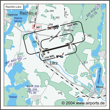
NAV Aids 069°/46 NM from BKD 117.70 226°/40 NM from FLD 117.15
Koordinaten 53 18, 31 N / 12 45, 13 E
Platzrunde / Traffic circuit N 1000
Landebahnen / RWY 1
RWY 2380 x 50 m, CONCRETE
RWY 08 TKOF 2080 m; LDG 2080 m
RWY 26 TKOF 2080 m; LDG 2080 m
MTOW PCN 37 R/A/W/T
Bemerkungen / Remarks Wohngebiete meiden!
Address:
ZIP / City D-17248 Lärz
Fon +49 (0)39833 / 22282
Images and information placed above are from http://www.airports.de/airport.php?ICAO=EDAX
We thank them for the data!
| General Info
|
| Country |
Germany
|
| ICAO ID |
EDAX
|
| Time |
UTC+1(+2DT)
|
| Latitude |
53.306417
53° 18' 23.10" N
|
| Longitude |
12.753139
012° 45' 11.30" E
|
| Elevation |
220 feet
67 meters
|
| Magnetic Variation |
002° E (01/05)
|
| Beacon |
Yes
|
| Operating Agency |
CIVIL GOVERNMENT, (LANDING FEES AND DIPLOMATIC CLEARANCE MAY BE REQUIRED)
|
| Alternate Name |
MURITZ
|
| Operating Hours |
SEE REMARKS FOR OPERATING HOURS OR COMMUNICATIONS FOR POSSIBLE HOURS
|
| Daylight Savings Time |
Last Sunday in March to last Sunday in October
|
| Communications
|
| LARZ INFO |
129.975
|
| Runways
|
ID
|
Dimensions |
Surface |
PCN |
ILS
|
| 08/26 |
7808 x 164 feet
2380 x 50 meters |
CONCRETE. |
037RAWT |
NO
|
| Supplies/Equipment
|
| Fuel |
100/130 MIL Spec, low lead, aviation gasoline (BLUE)
|
| Remarks
|
| CAUTION |
PJE; gldr act using winch launchers.
|
| FUEL |
(NC-100LL)
|
| MISC |
Ldg fees.
|
| OPR HOURS |
Opr 0800-SS/1700Z; 0900-SS/1700Z Sat, Sun, hol. OT PPR. (0700-SS/1700Z Mon-Fri; 0800-SS/1700Z Sat, Sun, hol. OT PPR DT).
|
| RSTD |
Avoid ovft Larz.
|
Runway 08/26
7808 x 164 feet
2380 x 50 meters
| Runway 08
|
| Surface |
CONCRETE.
|
| True Heading |
076.0
|
| Latitude |
53.303642
53° 18' 13.11" N
|
| Longitude |
12.735853
012° 44' 09.07" E
|
| Landing Distance |
6824 feet
2080 meters
|
| Takeoff Distance |
7808 feet
2380 meters
|
| Displaced Threshold Length |
984 feet
300 meters
|
| Lighting System |
MIRL
REIL |
| Runway 26
|
| Surface |
CONCRETE.
|
| True Heading |
256.0
|
| Latitude |
53.309189
53° 18' 33.08" N
|
| Longitude |
12.770428
012° 46' 13.54" E
|
| Landing Distance |
6824 feet
2080 meters
|
| Takeoff Distance |
7808 feet
2380 meters
|
| Displaced Threshold Length |
984 feet
300 meters
|
| Lighting System |
MIRL
REIL |
The content above was published at Airports-Worldwide.com in 2005.
We don't guarantee the information is fresh and accurate. The data may be wrong or outdated.
For more up-to-date information please refer to other sources.
|


