 |
|
Spangdahlem Military Airfield |
History
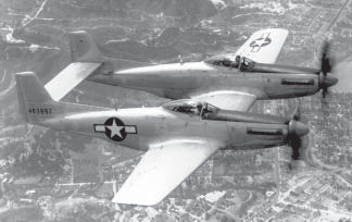
The 52d Fighter Wing, All Weather, was established on
10 May 1948, and activated on 9 June 1948. Stationed at Mitchel Field,
New York, the 52d was assigned to First Air Force and attached to Eastern
Air Defense Force from 10 November 1949 - 6 February 1952. During this
time, the 52d flew F-82 Twin Mustangs and F-94 Starfires.
 The
wing was redesignated as the 52d Fighter-All Weather Wing on 20 January
1950, and then became the 52d Fighter-Interceptor Wing on 1 May 1951.
The wing was inactivated on 6 February 1952, for a short time. However,
on 11 April 1963, the wing was redesignated and activated as the 52d Fighter
Wing (Air Defense). Stationed at Suffolk County AFB, New York, from 1
July 1963 - 30 September 1968, wing aircrews flew F-101 Voodoos. The
wing was redesignated as the 52d Fighter-All Weather Wing on 20 January
1950, and then became the 52d Fighter-Interceptor Wing on 1 May 1951.
The wing was inactivated on 6 February 1952, for a short time. However,
on 11 April 1963, the wing was redesignated and activated as the 52d Fighter
Wing (Air Defense). Stationed at Suffolk County AFB, New York, from 1
July 1963 - 30 September 1968, wing aircrews flew F-101 Voodoos.
Headquarters, United States Air Forces in Europe, activated the 52d Tactical
Fighter Wing at Spangdahlem AB, Germany, on 31 December 1971. Upon activation,
the 52d possessed two tactical units—the 23rd Tactical Fighter Squadron
(TFS) and the 39th Tactical Electronic Warfare Squadron (TEWS). The 23
TFS flew F-4D Phantom IIs while the 39 TEWS operated EB-66 Destroyer aircraft.
Headquarters USAFE activated the 39 TEWS at Spangdahlem AB on 1 January
1973. Meanwhile, the 81 TFS, equipped with F-4C Wild Weasel aircraft,
moved here from Zweibrucken AB, Germany, on 15 January 1973.
In April 1987, the wing began changing with the times and replaced its
aging F-4E jets with brand new F-16C/D Fighting Falcons just off the production
line. The last operational E model F-4 Phantom II aircraft departed Spangdahlem
AB in December 1987.
With this changeover, the 52 TFW secured a place in Air Force history
by becoming the first wing to successfully employ two completely different
fighters in a hunter/killer role within each of its tactical fighter squadrons.
Together, the F-4G and F-16C airplanes were capable of delivering almost
any munitions in the Air Force inventory with pinpoint accuracy.
On 6 April 1999, the 52d Fighter Wing (52d Air Expeditionary Wing) conducted
the first combat sorties flown from Germany since World War II in support
of Operation ALLIED FORCE (OAF). In addition to operating from Spangdahlem
AB, the 52d deployed personnel and equipment to Aviano AB and Lecce, Italy,
to support OAF. Operation ALLIED FORCE proved to be the largest military
endeavor undertaken by the 52d Fighter Wing since Operation DESERT STORM.
Units assigned to the 52d
generated over 3,000 sorties in support of OAF.
 In an effort to realign maintenance and logistics functions at Spangdahlem
AB, HQ USAFE reorganized the 52d Fighter Wing on 1 July 2002. Although
the reorganization did not begin until July 2002, the 52d began active
participation in the Chief of Staff of the Air Force Logistics Review
designed to streamline and improve USAF logistical and maintenance processes
on 24 Aug 2001. After being selected as one of seventeen test bases, the
52d began integrating the 52d Supply Squadron and 52d Transportation Squadron
functions into the 52d Logistics Readiness Squadron, Provisional. As part
of the reorganization, HQ USAFE redesignated several units 1 July 2002:
the 52d Logistics Group became the 52d Maintenance Group; the 52d Support
Group became the 52d Mission Support Group; the 52d Supply Squadron became
the 52d Logistics Readiness Squadron; the 52d Component Repair Squadron
became the 52d Component Maintenance Squadron; and the 52d Logistics Support
Squadron became the 52d Maintenance Operations Squadron. In addition,
HQ USAFE activated the 52d Aircraft Maintenance Squadron and inactivated
the 52d Transportation Squadron. Lastly, the 52d Contracting In an effort to realign maintenance and logistics functions at Spangdahlem
AB, HQ USAFE reorganized the 52d Fighter Wing on 1 July 2002. Although
the reorganization did not begin until July 2002, the 52d began active
participation in the Chief of Staff of the Air Force Logistics Review
designed to streamline and improve USAF logistical and maintenance processes
on 24 Aug 2001. After being selected as one of seventeen test bases, the
52d began integrating the 52d Supply Squadron and 52d Transportation Squadron
functions into the 52d Logistics Readiness Squadron, Provisional. As part
of the reorganization, HQ USAFE redesignated several units 1 July 2002:
the 52d Logistics Group became the 52d Maintenance Group; the 52d Support
Group became the 52d Mission Support Group; the 52d Supply Squadron became
the 52d Logistics Readiness Squadron; the 52d Component Repair Squadron
became the 52d Component Maintenance Squadron; and the 52d Logistics Support
Squadron became the 52d Maintenance Operations Squadron. In addition,
HQ USAFE activated the 52d Aircraft Maintenance Squadron and inactivated
the 52d Transportation Squadron. Lastly, the 52d Contracting
Squadron was moved from the 52d Logistics Group to the 52d Mission Support
Group.
In addition to the historically significant events already mentioned,
the men and women of Team Eifel remain involved in numerous deployments
around the globe—the members of the 52d Fighter Wing are always
prepared to SEEK ATTACK DESTROY.
PUBLIC AFFAIRS OFFICE
52d Fighter Wing Public Affairs
Unit 3680 Box 220
APO AE 09126
Tel DSN: 452-6012
Com: 06565-61-6012
FAX: 452-5254
URL: http://www.spangdahlem.af.mil/
Images and information placed above are from http://www.spangdahlem.af.mil/
We thank them for the data!
| General Info
|
| Country |
Germany
|
| ICAO ID |
ETAD
|
| Time |
UTC+1(+2DT)
|
| Latitude |
49.972667
49° 58' 21.60" N
|
| Longitude |
6.692500
006° 41' 33.00" E
|
| Elevation |
1197 feet
365 meters
|
| Type |
Military
|
| Magnetic Variation |
000° E (01/05)
|
| Beacon |
Yes
|
| Operating Agency |
U.S.AIR FORCE
|
| Near City |
Binsfeld
|
| Operating Hours |
SEE REMARKS FOR OPERATING HOURS OR COMMUNICATIONS FOR POSSIBLE HOURS
|
| International Clearance Status |
Airport of Entry
|
| Daylight Savings Time |
Last Sunday in March to last Sunday in October
|
| Communications
|
| TWR |
122.2
257.8
395.6
|
| LANGEN RADAR |
125.6
253.5
340.125
|
| PTD |
138.4
339.85
|
| COMD POST |
365.45
|
| PMSV METRO |
257.75
|
| GND |
138.8
279.2
|
| GND CLNC DEL |
279.2
|
GCA
Opr 0500-2100Z++ wkd.
|
129.475
290.4
|
| RHEIN RDR |
318.1
|
ATIS
Opr dur lcl Wg flying only.
|
143.425
369.45
|
| Runways
|
ID
|
Dimensions |
Surface |
PCN |
ILS
|
| 05/23 |
10007 x 148 feet
3050 x 45 meters |
ASPHALT |
078RAWT |
YES
|
| Navaids
|
| Type |
ID |
Name |
Channel |
Freq |
Distance From Field |
Bearing From Navaid
|
| TACAN |
SPA |
SPANGDAHLEM |
032X |
- |
At Field |
-
|
| Supplies/Equipment
|
| Fuel |
JP-8, SemiKeroscene MIL Spec T-83133, without icing inhibitor
|
| Oil |
O-148, MIL L 7808 (Synthetic Base), Turboprop/Turboshaft Engine
|
| Other Fluids |
SP, Single Point Refueling
DE-ICE, Anti-icing/De-icing/Defrosting Fluid (MIL A 8243)
LOX, Liquid oxygen servicing
|
| JASU |
A/M32A-86
AC:115/200v, 3 phase, 90 kva, 0.8pf, 4 wire, DC: 28v,1500 amp, 72kw
|
| Remarks
|
| A-GEAR |
BAK 12(B) 20 min PN req.
|
| CAUTION |
Large acft must use min pwr settings dur taxi OPS, inboard eng only. Ldg illusions exist on apch to Rwy 23. A 500' valley 0.5 NM short of thld may create the illusion that acft is abv GP on short final; Ceil often lo than rpt due to valley.Use ctn taxiing on ramp taxi lanes and ramps due to large volume of unctl veh tfc. Visual illusion on Rwy 05 and Rwy 23. Ovrn consists of 500' asphalt then 500' of conc leading to thld. The upslope of the ovrn and terrain causes a visualillusion of a steep GP. The asphalt/conc juncture creates a rwy/thld illusion short of the actual thld. Exer ctn while ldg when wet, a lower than avg BA and hydroplaning potential exists at ea rwy TD and cntrline 2000' fr the Rwy 23 end. Twy A, B, C, D, E and G, SE of Rwy 05/23, clsd and under const til aprx Aug 2005. Twy E hammerhead clsd FOD haz. 500' conc portion of ovrn/underrun apch end Rwy 05 and Rwy 23 keeled, may be used for taxi only. Midfield mnt lctd cntr 500' intoRwy 23 dep end ovrn. Textile A-G susceptible to pronounced 2 G-loading dur arrest potentially causing excessive rollback. 20' hi ILS ant 153' fr pavement end on cntrln ldg Rwy 23, 20' hi ILS ant 52' fr pavement end on cntrln ldg Rwy 05. Noauto-coupled apchs Rwy 05/23.
|
| FLUID |
SP De-Ice LOX
|
| FUEL |
J8
|
| JASU |
3(M32A-60) 3(32A-86)
|
| LGT |
Rwy 05/23 PAPI RRP not coincidental with ILS/PAR RPI. Rwy 23 apch lgt 2400'. Rwyedge lights are posn 13 ft fr edge of usable rwy sfc.
|
| MISC |
Rwy 05-23 ASP is grooved sfc, fst 986' Rwy 23 and 493' Rwy 05 is grooved conc sfc. VIS determined at 40' AGL. Wx full svc 0430-2100Z++ wkd, exc hol, hr vary according to lcl flying. When wx clsd, wx info avbl fr USAFE OPS Wx Squadron (OWS)DSN 496-6145/6. Wx and ATC facilities conduct cooperative wx watch for more accurate ceil and vis determination. Dur BWC Code MODERATE and SEVERE, aircrews should comply with owning MAJCOM/ unit guidance; aircrews can obtain current BWC frATIS/PTD/TWR. Classified stor at Comd Post. No COMSEC avbl.
|
| NS ABTMT |
Quiet hr in eff fr 2100-0600Z++ dly, Sun no tkof prior to 1200Z++ for jet acft. Dep after practice apch to Rwy 23 should avoid ovft of village 1.2 NM fr DER.
|
| OIL |
O-148
|
| OPR HOURS |
Opr 0500-2100Z++ wkd, clsd wkend and US hol.
|
| RSTD |
PPR at least 24 hr prior to arr. Ctc Base OPS ETS 452-6633/6048, C49-6565-61-6633/6048; fax: ETS 452-7467 C49-6565-61-7467 attn Base OPS; or thru AFTN: ETADYFYX. Pass VIP/haz cargo info 30 min prior to ldg to Comd Post/ or Base OPS. Airlift/ AMC acft ctc Comd Post 30 min out prior to ldg. 52 F/W Intel is avbl for mission support. Base OPS will provde point of ctc info. Ramp 4 rstd to C-17 and smaller. Conc portion of ovrn rstd to daylt use only. KC135 and larger proh fr taxing past arm/dearm pads on Twy P when acft are present. C17, KC10, C141 rstd fr using Twy B wo apvl fr Afld Mgr. Acft carrying haz cargo coord w Base OPS not later than 48 hr prior to arr. Crash recovery/emerg response capabilities ltd AMCacft.
|
| TFC PAT |
VFR tfc pat alt to SE, overhead 2700', rectangular 2200', lgt acft 1700'. Bitburg Arpt is 252 6 NM. USAFE acft only, reduced rwy separation apv for same type acft 3000' SR-SS and 6000' SR-SS when there is a reduced BA rpt or flw a formation or btn different type acft.
|
| TRAN ALERT |
Full svc 0600-2100Z++ Mon-Fri, 1100-1900Z++ US hol. Ltd svc avbl on wkend-prior coord rqr. Ltd tran fac/prk. No fleet svc avbl.
|
Runway 05/23
10007 x 148 feet
3050 x 45 meters
| Runway 05
|
| Surface |
ASPHALT
|
| True Heading |
045.0
|
| Latitude |
49.966792
49° 58' 00.45" N
|
| Longitude |
6.683561
006° 41' 00.82" E
|
| Elevation |
1127.0 feet
344 meters
|
| Slope |
0.7°
|
| Landing Distance |
10007 feet
3050 meters
|
| Takeoff Distance |
10500 feet
3200 meters
|
| Overrun Length |
493 feet
150 meters
|
| Overrun Surface |
ASPHALT
|
| Lighting System |
SF
CL
HIRL
REIL
A1
PAPI |
| Runway 23
|
| Surface |
ASPHALT
|
| True Heading |
225.0
|
| Latitude |
49.986292
49° 59' 10.65" N
|
| Longitude |
6.713456
006° 42' 48.44" E
|
| Elevation |
1197.0 feet
365 meters
|
| Slope |
-0.7°
|
| Landing Distance |
10007 feet
3050 meters
|
| Takeoff Distance |
10507 feet
3203 meters
|
| Overrun Length |
500 feet
152 meters
|
| Overrun Surface |
PART CONCRETE, PART ASPHALT, OR PART BITUMEN-BOUND MACADAM.
|
| Lighting System |
SF
CL
HIRL
REIL
A
PAPI |
Navaids
| SPANGDAHLEM
|
| Type |
ID |
Channel |
Freq |
Country |
State
|
| TACAN |
SPA |
032X |
- |
Germany |
-
|
| Latitude |
Longitude |
Airport
|
49.978994
49° 58' 44.38" N |
6.697697
006° 41' 51.71" E |
ETAD |
The content above was published at Airports-Worldwide.com in 2005.
We don't guarantee the information is fresh and accurate. The data may be wrong or outdated.
For more up-to-date information please refer to other sources.
|
|


