 |
 |
|
||||
|
Flying abroad with customer friendly (Customs) clearance are any time and without booking worldwide possible. One of the Especially experiences for our guests are the low priced Sightseeing flights over the town and the county of Straubing-Bogen, even over the Bavarian Forest and the famous alps. For vacation- and weekendtrips the airport is offering itself especially. Hospitality is a big word here in Straubing-Wallmühle. Our Airport-Restaurant has atmosphere. The extraordinary kitchen is glad to charm you. A special conference room is provided. Modern furnished hotel rooms invite you for an overnight stay. You will feel well in our cozy pilot´s-bar.The sightseeing platform with a view of the airfield is well visited at good weather conditions. Parking lots for cars and bicycles are, plentyful, at the front of the door available. The directly at the airport located lakes invite you in the summer to a refreshing swim, windsurfing or camping. In the winter will the "Eisstock-Sport"(similar to: curling) be indulgeded. Also for your plane will be well taken care. During the saison we are glad to provide service as aircraftwash, refuelling a.s.o.. In 10 aircrafthangars is enough space for approximately 100 airplanes. Aircraft parking lots outside and in hangar are available at convenient conditions. The Airport Straubing offers together with the resident companies 97 persons a safe job. The Airportfestival captures annually thousands of aviation enthusiastic spectators . There is no charge for admission and parking. The Organizer, the "Förderverein der Flieger e.V." spares no effort for annually new attractions;like vintage planes, hot airballoonride, reduced sightseeingflights a.s.o.. Worldclass-aerobatics will be showed by our aerobatic friends from all over the world. Also the German Air Force with its transport aircraft C130 "TRANSALL" as well as the German Army Helicopters are gladly seen guests. Also for the kids ("jumpercastle") and the physical well-being (aircrafthangar as beer-tent) is, also outdoors, best taken care of.
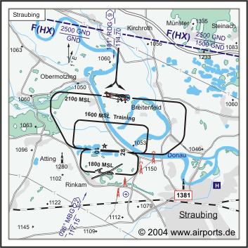
Kategorie Verkehrslandeplatz / Public Airfield Zoll / Customs Nur für Reisende ohne Handelsware/for passengers
without merchandise only 30 MIN Wartezeit vor Ausreise/nach Landung/30
MIN delay before DEP/after ARR Images and information placed above are from http://www.airports.de/airport.php?ICAO=EDMS http://www.airport-straubing.de We thank them for the data!
Runway 10/284429 x 98 feet
|
||||||||||||||||||||||||||||||||||||||||||||||||||||||||||||||||||||||||||||||||||||||||||||||||||||||||||||||||||||||||||||||||||||||||||||||||||||||
| Runway 10 | |
|---|---|
| Surface | ASPHALT |
| True Heading | 097.0 |
| Latitude | 48.901622 48° 54' 05.84" N |
| Longitude | 12.507517 012° 30' 27.06" E |
| Elevation | 1053.0 feet 321 meters |
| Slope | -0.2° |
| Landing Distance | 4101 feet 1250 meters |
| Takeoff Distance | 4560 feet 1390 meters |
| Displaced Threshold Length | 328 feet 100 meters |
| Overrun Length | 131 feet 40 meters |
| Overrun Surface | ASPHALT |
| Lighting System | HIRL
REIL PAPI |
| Runway 28 | |
|---|---|
| Surface | ASPHALT |
| True Heading | 277.0 |
| Latitude | 48.900136 48° 54' 00.49" N |
| Longitude | 12.525806 012° 31' 32.90" E |
| Elevation | 1045.0 feet 319 meters |
| Slope | 0.2° |
| Landing Distance | 4429 feet 1350 meters |
| Takeoff Distance | 4626 feet 1410 meters |
| Overrun Length | 197 feet 60 meters |
| Overrun Surface | ASPHALT |
| Lighting System | HIRL
REIL T PAPI |
The content above was published at Airports-Worldwide.com in 2005.
We don't guarantee the information is fresh and accurate. The data may be wrong or outdated.
For more up-to-date information please refer to other sources.

 |
|
Copyright 2004-2026 © by Airports-Worldwide.com, Vyshenskoho st. 36, Lviv 79010, Ukraine Legal Disclaimer |
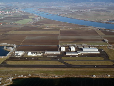 The
airport Straubing-Wallmühle has an opening function for
Straubing, for Regensburg as well as for the entire East Bayaria. It belongs
to the most extended airfields in Bavaria. Business-, Work- und airtraffic
on demand form the daily picture in Wallmühle. Flying in Straubing
has a long tradition, which is well cultivated.
The
airport Straubing-Wallmühle has an opening function for
Straubing, for Regensburg as well as for the entire East Bayaria. It belongs
to the most extended airfields in Bavaria. Business-, Work- und airtraffic
on demand form the daily picture in Wallmühle. Flying in Straubing
has a long tradition, which is well cultivated.
 ICAO
Code EDMS
ICAO
Code EDMS