 |
|
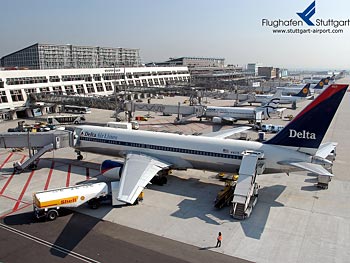
Stuttgart International Airport |
 Gotthilf Fischer gehört zu den bekanntesten Gesichtern im deutschen
Fernsehen – das besagt zumindest eine Studie des SWR. Ob auch seine
Stimme zu den markantesten im deutschen Radio zählt, ist zwar nicht
untersucht, aber sehr wahrscheinlich. Wer ihn hören will, hat dazu
am Montag, 25. Juli, die Gelegenheit. Dann ist er von 10 bis 12 Uhr zu
Gast bei SWR1 Leute, live vom Stuttgarter Flughafen. Wolfgang Heim moderiert
die Sendung im Terminal 1, Ebene 5 unter dem roten Doppeldecker. Karten
sind bei der Esslinger Zeitung und SWR1 Baden-Württemberg zu gewinnen.
Gotthilf Fischer gehört zu den bekanntesten Gesichtern im deutschen
Fernsehen – das besagt zumindest eine Studie des SWR. Ob auch seine
Stimme zu den markantesten im deutschen Radio zählt, ist zwar nicht
untersucht, aber sehr wahrscheinlich. Wer ihn hören will, hat dazu
am Montag, 25. Juli, die Gelegenheit. Dann ist er von 10 bis 12 Uhr zu
Gast bei SWR1 Leute, live vom Stuttgarter Flughafen. Wolfgang Heim moderiert
die Sendung im Terminal 1, Ebene 5 unter dem roten Doppeldecker. Karten
sind bei der Esslinger Zeitung und SWR1 Baden-Württemberg zu gewinnen.
Die Karriere Gotthilf Fischers begann unweit des Stuttgarter Flughafens:
Nach Kriegsende leitete er den Deizisauer Gesangverein Concordia. Heute
sind die Massen seine Spezialität. Ob es darum geht, sie zu dirigieren,
sie zu einer Gemeinschaft zusammenzuschweißen oder deutsches Liedgut
zu verbreiten – die Mammutchöre des heute 77 Jahre alten Chorleiters
wurden mit einem Auftritt bei der Fußballweltmeisterschaft 1974
in München sogar international zu einem Begriff.
Mehr als 1.500 Sänger versammelte Gotthilf Fischer bei einzelnen
Massenauftritten, ein stimmgewaltiger Griff zu den Weltrekorden. Gleich
drei stellte der Chorleiter auf: Er dirigierte den „Größten
Wasserchor der Welt“, ließ die „meisten Walzer tanzenden
Paare im Wasser“ im Dreivierteltakt sich drehen und leitete den
„Größten Bergmannschor“. Ergebnis seiner Höchstleistungen:
weit über 16 Millionen verkaufte Schallplatten, Hunderte von Auszeichnungen
in Gold und Platin sowie unzählige Fernsehauftritte. Für den
SWR geht Fischer regelmäßig mit der Serie „Straße
der Lieder“ auf musikalische Reisen.
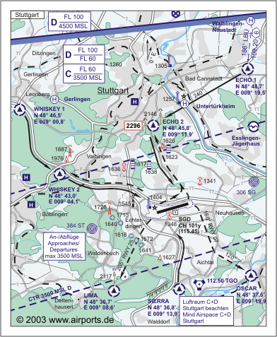 ICAO
Code EDDS ICAO
Code EDDS
IATA Code STR
Name STUTTGART
Land Deutschland
Bundesland Baden-Württemberg
Letzte Änderung 8. Juli 2004
Kategorie Int. Verkehrsflughafen / Int. Airport
Betreiber / Operator Flughafen Stuttgart GmbH
Lage / Location 5.5 NM S Stadtmitte/Centre of Stuttgart
Nachtflug / NVFR NVFR
Instrumentenflug / IFR IFR
LFZ / ACFT Bis / up to PCN 80 R/C/X/T
Helicopter Ja / Yes
Andere Luftfahrzeuge/other aircraft PPR
Summer H 24, CTR H 24
Winter H 24, CTR H 24
Enschränkungen siehe AIP VFR Kartenteil/Restrictions see AIP VFR
chart section
Luftaufsicht / OPS +49 (0)711 / 9483482
AIS AIS-Centre EDDZ, +49 (0)69 / 78072500
ACC EDDF +49 (0)6103 / 7076200
APP
MET (0190) 077227
Gafor 53
Zoll / Customs H 24
Fuel 100 LL, Jet A1
Oil Alle gebräuchlichen Sorten/All common grades
Hangar Nein / No
Höhe / Elevation 1276 ft / 383 m
FIS Langen Information 128.950
VDF / QDM O/R
Rufzeichen / Call sign Stuttgart Tower/Turm
Frequenz Tower 119.050 EN/GE 118.800 EN/GE
Frequenz Ground 121.900 EN/GE
NAV Aids ABN PAPI DME SGD 115.45 am Platz/at field ILS RWY 25 109.90 ILS
RWY 07 110.90
Koordinaten 48 41, 39 N / 09 13, 32 E
Landebahnen / RWY 1
RWY 3345 x 45 m, CONCRETE
RWY 07 TKOF 3345 m; LDG 3045 m
RWY 25 TKOF 3045 m; LDG 3345 m
MTOW 80 R/C/X/T
Restaurant Ja
Adresse
Postfach 230461
ZIP / City D-70624
Stuttgart
Fon +49 (0)711 / 9480
Fax 9482241
URL http://www.stuttgart-airport.de
Images and information placed above are from http://www.stuttgart-airport.de
http://www.airports.de/airport.php?ICAO=EDDS
We thank them for the data!
| General Info
|
| Country |
Germany
|
| ICAO ID |
EDDS
|
| Time |
UTC+1(+2DT)
|
| Latitude |
48.689878
48° 41' 23.56" N
|
| Longitude |
9.221964
009° 13' 19.07" E
|
| Elevation |
1276 feet
389 meters
|
| Type |
Joint (Civil and Military)
|
| Magnetic Variation |
001° E (01/05)
|
| Beacon |
Yes
|
| Operating Agency |
U.S.ARMY
|
| Alternate Name |
ECHTERDINGEN AAF
|
| Operating Hours |
SEE REMARKS FOR OPERATING HOURS OR COMMUNICATIONS FOR POSSIBLE HOURS
|
| International Clearance Status |
Airport of Entry
|
| Daylight Savings Time |
Last Sunday in March to last Sunday in October
|
| Communications
|
TWR
118.6/278.05 (Opr SR-30-SS+30)
|
118.8
119.05
337.75
118.6
278.05
|
| APRON |
121.7
|
| LANGEN RADAR |
119.2
125.05
338.65
|
| BASE OPS PTD |
31.8
141.65
343.55
|
| DEICING |
136.825
|
| LANGEN INFO |
128.95
|
| GND |
121.9
|
| DIR |
119.85
279.35
|
ATIS
Opr 0450-2250Z++
|
126.125
|
| Runways
|
ID
|
Dimensions |
Surface |
PCN |
ILS
|
| 07/25 |
10974 x 148 feet
3345 x 45 meters |
CONCRETE. |
080RCXT |
YES
|
| Navaids
|
| Type |
ID |
Name |
Channel |
Freq |
Distance From Field |
Bearing From Navaid
|
| VOR-DME |
LBU |
LUBURG |
029X |
109.2 |
14.2 NM |
198.6
|
| NDB |
SY |
STUTTGART |
- |
384 |
4.5 NM |
073.3
|
| DME |
SGD |
STUTTGART |
101Y |
- |
At Field |
-
|
| Supplies/Equipment
|
| Fuel |
Jet A1+, Jet A1 with icing inhibitor.
JP-8, SemiKeroscene MIL Spec T-83133, without icing inhibitor
100/130 MIL Spec, low lead, aviation gasoline (BLUE)
|
| JASU |
A/M32A-86
AC:115/200v, 3 phase, 90 kva, 0.8pf, 4 wire, DC: 28v,1500 amp, 72kw
MA-1A
82lb/min (1123cfm) at 130 deg air inlet temp,45psia(min) air outlet
|
| Remarks
|
| CAUTION |
Freq seasonal bird concentration on/near rwy. Twy stopbars avbl on Twy A, B, C, D, E, F, G, H, dur Cat 1 lo vis opr. Cranes vcnty apch end Rwy 07 to 241' AGL.
|
| FLUID |
De-Ice
|
| FUEL |
J8 (Air BP/SFS) avbl 0600-2300Z++, fone C49-71-1948-4040. Ntc aft 2300Z++, 8 hr prior ntc, $125/hr fone C44-1-202-590-558. (NC-100LL, A1).
|
| JASU |
2(A/M 32A-86) 1(MA-1A)
|
| LGT |
PAPI Rwy 07 MEHT 56', PAPI Rwy 25 MEHT 60'.
|
| MISC |
Tapley meter used for RCR. Minimize abrupt brkg/turns/hi-pwr/reverse thrust. Ctcmil ramp prior to taxiing/hovering on Mil ramp/twy. Arr acft ctc Base OPS 20 min prior to ldg with intentions and/or VIP codes. Outbd VFR flt ctc GND CON aft eng start for flt data. Ctc INFO for FLT FLW svc, do not ctc Base OPS. Fone Base OPS DSN 421-4273, C0711-729-4273; Afld Mgr DSN 421-4103, C0711-729-4103; Tran Alert DSN 421-4253/4001, C0711-729-4253/4001; USEUCOM Flt OPS DSN 421-4214/4268; USEUCOM Flt OPS Protocol DSN 421-4107, C0711-729-4107. Base OPS fax DSN 421-4109,C0711-729-4109. Wx fcst avbl 24 hr thru Sembach DSN 496-6145 or civ 06302-63-6145. Flt plans of acft intending to use mil site for parking have to be sent to EDDSYXYX.
|
| NS ABTMT |
Strict compliance with VFR Arr/Dep Rte rqr.
|
| OPR HOURS |
Mil afld opr hr 0500-2100Z++ Mon-Fri; 0600-1400Z++ Sat, Sun.
|
| RSTD |
48 hr PPR for acft arriving and/or departing mil site outside ops hrs, acft over59' wg span or rotor diameter and all acft carrying a VIP code 7 or above. PPRfor multiple inst apch, fone C 06103-7076200.
|
Runway 07/25
10974 x 148 feet
3345 x 45 meters
| Runway 07
|
| Surface |
CONCRETE.
|
| True Heading |
074.0
|
| Latitude |
48.685733
48° 41' 08.64" N
|
| Longitude |
9.200128
009° 12' 00.46" E
|
| Elevation |
1276.0 feet
389 meters
|
| Slope |
-0.9°
|
| Landing Distance |
9990 feet
3045 meters
|
| Takeoff Distance |
11171 feet
3405 meters
|
| Displaced Threshold Length |
984 feet
300 meters
|
| Overrun Length |
197 feet
60 meters
|
| Overrun Surface |
ASPHALT
|
| Lighting System |
SF
TDZL
CL
HIRL
REIL
A
PAPI |
| Runway 25
|
| Surface |
CONCRETE.
|
| True Heading |
254.0
|
| Latitude |
48.694017
48° 41' 38.46" N
|
| Longitude |
9.243803
009° 14' 37.69" E
|
| Elevation |
1181.0 feet
360 meters
|
| Slope |
0.9°
|
| Landing Distance |
10974 feet
3345 meters
|
| Takeoff Distance |
11138 feet
3395 meters
|
| Overrun Length |
164 feet
50 meters
|
| Overrun Surface |
ASPHALT
|
| Lighting System |
SF
TDZL
CL
HIRL
REIL
A
PAPI |
Navaids
| LUBURG
|
| Type |
ID |
Channel |
Freq |
Country |
State
|
| VOR-DME |
LBU |
029X |
109.2 |
Germany |
-
|
| Latitude |
Longitude |
Airport
|
48.912975
48° 54' 46.71" N |
9.340228
009° 20' 24.82" E |
EDDS |
Navaids
| STUTTGART
|
| Type |
ID |
Channel |
Freq |
Country |
State
|
| NDB |
SY |
- |
384 |
Germany |
-
|
| Latitude |
Longitude |
Airport
|
48.669244
48° 40' 09.28" N |
9.114203
009° 06' 51.13" E |
EDDS |
Navaids
| STUTTGART
|
| Type |
ID |
Channel |
Freq |
Country |
State
|
| DME |
SGD |
101Y |
- |
Germany |
-
|
| Latitude |
Longitude |
Airport
|
48.687947
48° 41' 16.61" N |
9.224106
009° 13' 26.78" E |
EDDS |
The content above was published at Airports-Worldwide.com in 2005.
We don't guarantee the information is fresh and accurate. The data may be wrong or outdated.
For more up-to-date information please refer to other sources.
|
|


