 |
|
 ICAO
Code EDRT ICAO
Code EDRT
Name TRIER - Föhren
Land Deutschland
Bundesland Rheinland-Pfalz
Letzte Änderung 31. März 2005
Kategorie Verkehrslandeplatz und Militär / Civil
Betreiber / Operator a) Bundeswehr, b) Flugplatz GmbH Trier
Lage / Location 8 NM NE Trier
LFZ / ACFT Bis / up to 15000 kg
Helicopter Ja / Yes
Glider (P, selbststartend/self-launching)
Summer 0800-SS/1900
Winter 0900-SS
O/T PPR
Platzrundenflüge an Sat sowie an allen Werktagen vor 1000 (0900)PPR/Pattern
traffic on Sat and on all workdays before 1000 (0900)PPR Sun + HOL Platzrundenflüge
nicht erlaubt/Pattern traffic not permitted Weitere Einschränkungen
siehe AD 1-6/ additional restrictions see AD 1-6
Luftaufsicht / OPS +49 (0)6502 / 2999, Fax 7949,
AIS AIS-Centre EDDZ, +49 (0)69 / 78072500
ACC EDDF +49 (0)6103 / 7076200
MET (0190) 077223
Gafor 37
Zoll / Customs O / R 1 HR im nichtgewerblichen Verkehr oder im Gelegenheitsverkehr
zur Personenbeförderung/for non-commercial traffic or non.scheduled
traffic for the transport of passengers
Fuel 100 LL, Jet A1
Oil 15W50, W 100
Hangar Nein / No
Höhe / Elevation 665 ft / 203 m
FIS Langen Information 123.525
VDF / QDM 122.050, 122.500
Rufzeichen / Call sign Trier Info
Frequenz Tower 122.050, 122.500 EN/GE
NAV Aids 134°/14 NM from NTM 115.30 273°/23 NM from KIR 117.50,
327°/45 NM from "ZWN" (114.80)
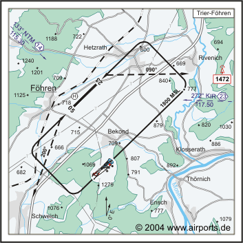
Koordinaten 49 51, 81 N / 06 47, 29 E
Platzrunde / Traffic circuit SE 1800
Landebahnen / RWY 1
RWY 1200 x 30 m, CONCRETE
RWY 05 TKOF 1130 m; LDG 1200 m
RWY 23 TKOF 1200 m; LDG 1130 m
MTOW 15000 kg
Bemerkungen / Remarks Wohngebiete meiden!
Restaurant Ja
Adresse
Flugleitung - Tower
ZIP / City D-54343
Föhren
Fon +49 (0) 6502 / 2999
Fax 7949
URL http://www.flugplatz-trier.de
eMail flugleitung at flugplatz-trier de
Images and information placed above are from http://www.flugplatz-trier.de
http://www.airports.de/airport.php?ICAO=EDRT
We thank them for the data!
| General Info
|
| Country |
Germany
|
| ICAO ID |
EDRT
|
| Time |
UTC+1(+2DT)
|
| Latitude |
49.863336
49° 51' 48.01" N
|
| Longitude |
6.788889
006° 47' 20.00" E
|
| Elevation |
665 feet
203 meters
|
| Magnetic Variation |
000° E (01/05)
|
| Operating Agency |
MILITARY - CIVIL JOINT USE AIRPORT
|
| Operating Hours |
SEE REMARKS FOR OPERATING HOURS OR COMMUNICATIONS FOR POSSIBLE HOURS
|
| Daylight Savings Time |
Last Sunday in March to last Sunday in October
|
| Communications
|
| INFO |
122.05
|
| LANGEN INFO |
123.525
|
| Runways
|
ID
|
Dimensions |
Surface |
PCN |
ILS
|
| 05/23 |
3937 x 98 feet
1200 x 30 meters |
CONCRETE. |
- |
NO
|
| Supplies/Equipment
|
| Fuel |
Jet A1, without icing nhibitor.
100/130 MIL Spec, low lead, aviation gasoline (BLUE)
|
| Remarks
|
| CSTMS/AG/IMG |
O/R 1 hr.
|
| FUEL |
(NC-100LL, A1)
|
| NS ABTMT |
Before 0600Z++, btn 1200-1400Z++, aft SS Mon-Fri. Before 0800Z++ and aft 1200Z++Sat, Sun, hol.
|
| OPR HOURS |
Opr 0900Z++-SS, OT PPR.
|
Runway 05/23
3937 x 98 feet
1200 x 30 meters
| Runway 05
|
| Surface |
CONCRETE.
|
| True Heading |
046.0
|
| Latitude |
49.859572
49° 51' 34.46" N
|
| Longitude |
6.782911
006° 46' 58.48" E
|
| Elevation |
665.0 feet
203 meters
|
| Slope |
0.0°
|
| Landing Distance |
3937 feet
1200 meters
|
| Takeoff Distance |
3937 feet
1200 meters
|
| Runway 23
|
| Surface |
CONCRETE.
|
| True Heading |
226.0
|
| Latitude |
49.867097
49° 52' 01.55" N
|
| Longitude |
6.794869
006° 47' 41.53" E
|
| Elevation |
665.0 feet
203 meters
|
| Slope |
0.0°
|
| Landing Distance |
3707 feet
1130 meters
|
| Takeoff Distance |
3937 feet
1200 meters
|
| Displaced Threshold Length |
230 feet
70 meters
|
The content above was published at Airports-Worldwide.com in 2005.
We don't guarantee the information is fresh and accurate. The data may be wrong or outdated.
For more up-to-date information please refer to other sources.
|
|


