|
 ICAO
Code EDBW ICAO
Code EDBW
Name WERNEUCHEN
Land Deutschland
Bundesland Brandenburg
Letzte Änderung 8. Dezember 2004
Kategorie Sonderlandeplatz / Special Airfield
Betreiber / Operator Flugplatz Werneuchen GmbH
Lage / Location 1.1 NM E Werneuchen
LFZ / ACFT Bis / up to 5700 kg
Helicopter Ja / Yes
Motorsegler / GLDP Ja / Yes
UL Ja / Yes
Summer PPR
Winter PPR
O/T PPR
Luftaufsicht / OPS +49 (0)151 / 16333724
PPR +49 (0)151 / 16333724
AIS EDDB +49 (0)30 / 60918250
MET (0190) 077222
Gafor 18
Zoll / Customs Nein / No
Fuel
Oil 80, 100, 15W50
Hangar Ja / Yes
Höhe / Elevation 263 ft / 80 m
FIS Berlin Information 126.350
Rufzeichen / Call sign Werneuchen Info
Frequenz Tower 122.600 GE
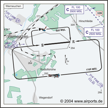
NAV Aids 085°/15 NM from DLS 413.5 125°/29 NM from LWB 114.55
314°/19 NM from FWE 113.30
Koordinaten 52 37, 98 N / 13 46, 02 E
Platzrunde / Traffic circuit S 1100
Landebahnen / RWY 1
RWY 1499 x 80 m, HARTBELAG / PAVED SURFACE
RWY 08 TKOF 1499 m; LDG 1499 m
RWY 26 TKOF 1499 m; LDG 1499 m
MTOW 5700 kg
Bemerkungen / Remarks Wohngebiete meiden! Airspace C 2500 MSL/FL 100
Restaurant Ja
Adresse
Alte Hirschfelder Straße 6
ZIP / City D-16356
Werneuchen
Fon +49 (0)33398 / 8240
Fax 82424
URL: http://www.airports.de/airport.php?ICAO=EDBW
Images and information placed above are from http://www.airports.de/airport.php?ICAO=EDBW
We thank them for the data!
| General Info
|
| Country |
Germany
|
| ICAO ID |
EDBW
|
| Time |
UTC+1(+2DT)
|
| Latitude |
52.633000
52° 37' 58.80" N
|
| Longitude |
13.767000
013° 46' 01.20" E
|
| Elevation |
263 feet
80 meters
|
| Magnetic Variation |
002° E (01/05)
|
| Operating Agency |
PRIVATE
|
| Daylight Savings Time |
Last Sunday in March to last Sunday in October
|
| Communications
|
| INFO |
122.6
|
| BERLIN INFO |
126.35
|
| Runways
|
ID
|
Dimensions |
Surface |
PCN |
ILS
|
| 08/26 |
4918 x 262 feet
1499 x 80 meters |
CONCRETE. |
- |
NO
|
| Remarks
|
| CAUTION |
Gldr act. Apch Rwy 08 has 3281' non-use prev sfc with 13' mound at beginning and3' mound 1066' before thld.
|
| OPR HOURS |
Opr PPR.
|
| RSTD |
Avoid ovft Rudolfshohe, Hirschfelde, Werneuchen villages.
|
Runway 08/26
4918 x 262 feet
1499 x 80 meters
| Runway 08
|
| Surface |
CONCRETE.
|
| True Heading |
085.0
|
| Latitude |
52.631333
52° 37' 52.80" N
|
| Longitude |
13.764525
013° 45' 52.29" E
|
| Landing Distance |
4918 feet
1499 meters
|
| Takeoff Distance |
4918 feet
1499 meters
|
| Runway 26
|
| Surface |
CONCRETE.
|
| True Heading |
265.0
|
| Latitude |
52.632486
52° 37' 56.95" N
|
| Longitude |
13.786583
013° 47' 11.70" E
|
| Landing Distance |
4918 feet
1499 meters
|
| Takeoff Distance |
4918 feet
1499 meters
|
The content above was published at Airports-Worldwide.com in 2005.
We don't guarantee the information is fresh and accurate. The data may be wrong or outdated.
For more up-to-date information please refer to other sources.
|


