 |
 |
|
||||
|
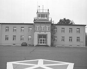
The area that is presently Wiesbaden Army Airfield has a long history of use as festival grounds. As early as 1184 a national festival was held on the grounds and the German emperor Friedrich I, knighted his sons there. In later years a racetrack, which was well known throughout Europe for its excellent horse racing competition, was built on the site. On May 11, 1913 Prince Heinrich of Prussia landed in a field near the racetrack, thus completing the first recorded landing by an aircraft on what is now Wiesbaden Army Airfield. Around 1917, due to a decline in racetrack attendance, sponsors included aerial demonstrations as a regular part of the program. During these flying programs some of the most famous German stunt pilots made their appearance at Wiesbaden. Wiesbaden was not used as a military aerodrome during the First World War. In 1926 a retired German Flying Corps officer, Joseph Aumann, conceived the idea of turning the racetrack into an airfield. Although Aumann's idea did not win public approval he managed to convince city officials that the airfield would attract more visitors to the Spas of Wiesbaden and stimulate business in Wiesbaden and Mainz. In late March 1945 Fliegerhorst Wiesbaden was abandoned by the Luftwaffe and occupied by advancing American soldiers. U.S. troops remained on Fliegerhorst Wiesbaden after the war, and in September 1947, the U.S. Army Air Corps became a separate service—the U.S. Air Force. At that time in 1948, Fliegerhorst Wiesbaden was designated Wiesbaden Air Base and was the home of Headquarters U.S. Air Force in Europe. During the Berlin Airlift of 1949, airmen from Wiesbaden distinguished themselves in support of "Operation Vittles". C52's and C84 "Flying Boxcars" of the 60th Troop Carrier Group flew missions daily from Wiesbaden to Tempelhof Airport in the beleaguered city of Berlin. During one day's operations more than 80 tons of food and supplies were airlifted from Wiesbaden Air Base. The streets on Wiesbaden Army Airfield are named after servicemen that gave their lives during the Berlin Airlift. In 1976 USAFE and all USAF flying units moved to Ramstein and were replaced at Wiesbaden Air Base by an U.S. Army Mechanized Infantry Brigade. During this period flying activities at Wiesbaden were greatly reduced. In 1983 the unit was de-activated and the decision made to use the Air Base for its primary purpose—that of an aviation facility. Although it retained the name Wiesbaden Air Base, at that time Wiesbaden AAF became the primary airfield of the U.S. Army V Corps. Wiesbaden now serves as the home station of the 221st Base Support Battalion, 1st. Armored Division Headquarters, 3d COSCOM, 205th Military Intelligence Brigade, and C Company of the 5th Battalion, 58th Aviation Regiment. In 1998 the Air Base was officially renamed Wiesbaden Army Airfield.
http://www.wiesbaden.army.mil/ Images and information placed above are from http://www.wiesbaden.army.mil/
Runway 07/257065 x 120 feet
|
||||||||||||||||||||||||||||||||||||||||||||||||||||||||||||||||||||||||||||||||||||||||||||||||||||||||||||||||||||||||||||||||||||||||||||||||||||||||||||||||||||||||||||||||||||||||||||||||||||||||||||||||||||||||||||||||||||||||||||||||||||||
| Runway 07 | |
|---|---|
| Surface | ASPHALT |
| True Heading | 073.0 |
| Latitude | 50.047053 50° 02' 49.39" N |
| Longitude | 8.311031 008° 18' 39.71" E |
| Elevation | 456.0 feet 139 meters |
| Slope | 0.1° |
| Landing Distance | 7065 feet 2153 meters |
| Takeoff Distance | 7215 feet 2199 meters |
| Overrun Length | 150 feet 46 meters |
| Overrun Surface | ASPHALT |
| Lighting System | PCL
HIRL REIL PAPI |
| Runway 25 | |
|---|---|
| Surface | ASPHALT |
| True Heading | 253.0 |
| Latitude | 50.052603 50° 03' 09.37" N |
| Longitude | 8.339836 008° 20' 23.41" E |
| Elevation | 461.0 feet 141 meters |
| Slope | -0.1° |
| Landing Distance | 6944 feet 2117 meters |
| Takeoff Distance | 7215 feet 2199 meters |
| Displaced Threshold Length | 121 feet 37 meters |
| Overrun Length | 150 feet 46 meters |
| Overrun Surface | ASPHALT |
| Lighting System | PCL
HIRL BP PAPI |
| WIESBADEN | |||||
|---|---|---|---|---|---|
| Type | ID | Channel | Freq | Country | State |
| TACAN | WIB | 088X | - | Germany | - |
| Latitude | Longitude | Airport |
| 50.046167 50° 02' 46.20" N |
8.310833 008° 18' 39.00" E |
ETOU |
| WIESBADEN | |||||
|---|---|---|---|---|---|
| Type | ID | Channel | Freq | Country | State |
| NDB | WBD | - | 399 | Germany | - |
| Latitude | Longitude | Airport |
| 50.049000 50° 02' 56.40" N |
8.328667 008° 19' 43.20" E |
ETOU |
The content above was published at Airports-Worldwide.com in 2005.
We don't guarantee the information is fresh and accurate. The data may be wrong or outdated.
For more up-to-date information please refer to other sources.

 |
|
Copyright 2004-2026 © by Airports-Worldwide.com, Vyshenskoho st. 36, Lviv 79010, Ukraine Legal Disclaimer |
 History
of Wiesbaden Army Airfield
History
of Wiesbaden Army Airfield