 |
|
Aero-Club Ludwigshafen e.V.
 Flüge
verschenken - Rundflüge oder Flugstunden sind eine ideale Geschenkidee.
Details finden Sie unter Rundflüge oder Schnupperflüge. Flüge
verschenken - Rundflüge oder Flugstunden sind eine ideale Geschenkidee.
Details finden Sie unter Rundflüge oder Schnupperflüge.
Fliegen lernen - Informationen zur Flugausbildung finden Sie unter Flugschule.
Unsere Homepage soll Ihnen einen Überblick über die Aktivitäten
unseres Vereins geben. Für die Ausbildung zum Privatpiloten (Privatpilotenlizenz,
PPL) für Motorflugzeuge und Motorsegler bieten wir ein umfangreiches
Ausbildungsprogramm in unserer Flugschule. Auch Schnupperflüge für
Interessierte an der Ausbildung sind jederzeit möglich.
Ebenso führen wir auf Wunsch Rundflüge durch. Beliebte Ziele
für einen Rundflug sind das Rhein-Main-Gebiet, Heidelberg, die Bergstraße,
die Weinstraße, der Odenwald und die Pfalz. Auch Flüge mit
Landung auf Nachbarflugplätzen (zum Beispiel in Egelsbach, Aschaffenburg,
Michelstadt, Mosbach, Walldürn, Mainbullau, Mainz, Oppenheim, Langenlonsheim,
Bad Dürkheim, Speyer, Pirmasens, Zweibrücken oder Mannheim)
sind möglich.
 ICAO
Code EDFV ICAO
Code EDFV
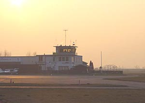
Name WORMS
Land Deutschland
Bundesland Rheinland-Pfalz
Letzte Änderung 14. August 2004
Kategorie Verkehrslandeplatz / Public Airfield
Betreiber / Operator Flugplatz GmbH Worms-Frankenthal-Ludwigshafen,
Geschäftsführung
Lage / Location 1.4 NM S Worms
Nachtflug / NVFR NVFR
LFZ / ACFT Bis / up to 5700 kg, 10000 kg PPR
Helicopter Ja / Yes
Motorsegler / GLDP Ja / Yes
Segelflugzeuge / GLD Ja / Yes
UL Ja / Yes
Summer 0600-SS/1830, PPR 0500-0600, SS/1830-2000
Winter 0800-SS+30, PPR 0600-0800, SS+30-2100
O/T PPR
Einschränkungen siehe AD 1-6/ restrictions see AD 1-6
Luftaufsicht / OPS +49 (0)6241 / 25444, Fax 23454
PPR +49 (0)6241 / 25444, Fax 23454
AIS AIS-Centre EDDZ, +49 (0)69 / 78072500
ACC EDDF +49 (0)6103 / 7076200
MET (0190) 077224
Gafor 45
Zoll / Customs nein/no
Zoll / Customs Fon +49 (0)6241 / 946220, Fax 946229
Fuel 100 LL, Jet A1
Oil 80/100, W80, W100, 15W50, W100plus
Hangar PPR
Höhe / Elevation 295 ft / 90 m
FIS Frankfurt Information 123.325
VDF / QDM 124.600
Rufzeichen / Call sign Worms Info
Frequenz Tower 124.600 EN/GE
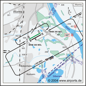
NAV Aids 348°/4 NM from HDM 334 302°/5 NM from HDM 109.00 213°/13
NM from RID 112.20
Koordinaten 49 36, 38 N / 08 22, 01 E
Platzrunde / Traffic circuit S 1300
Landebahnen / RWY 2
RWY 800 x 23 m, ASPHALT
RWY 06 TKOF 800 m; LDG 800 m
RWY 24 TKOF 800 m; LDG 800 m
MTOW 5700 kg, PPR 10000 kg
RWY II 920 x 30 m, Gras
RWY 06 TKOF 920 m; LDG 820 m
RWY 24 TKOF 920 m; LDG 820 m
MTOW RWY II 2000 kg
Bemerkungen / Remarks Coleman CTR beachten, GRAS RWY PPR, Wohngebiete
meiden!
Restaurant Ja
Adresse
Am flugplatz 1
ZIP / City D-67547 Worms
Fon +49 (0)6241 / 25444
Fax 23454
http://www.acl-worms.de
E-mail: vorstand at acl-worms de
Images and information placed above are from
http://www.airports.de/airport.php?ICAO=EDFV
http://www.acl-worms.de
We thank them for the data!
| General Info
|
| Country |
Germany
|
| ICAO ID |
EDFV
|
| Latitude |
49.606511
49° 36' 23.44" N
|
| Longitude |
8.368400
008° 22' 06.24" E
|
| Elevation |
295 feet
90 meters
|
| Magnetic Variation |
000° E (01/05)
|
| Beacon |
Yes
|
| Operating Agency |
CIVIL GOVERNMENT, (LANDING FEES AND DIPLOMATIC CLEARANCE MAY BE REQUIRED)
|
| Communications
|
| INFO |
124.6
|
| LANGEN INFO |
126.95
|
| Runways
|
ID
|
Dimensions |
Surface |
PCN |
ILS
|
| 06R/24L |
2625 x 66 feet
800 x 20 meters |
CONCRETE. |
- |
NO
|
| 06L/24R |
3018 x 98 feet
920 x 30 meters |
GRASS OR EARTH NOT GRADED OR ROLLED. |
- |
NO
|
| Supplies/Equipment
|
| Fuel |
Jet A1+, Jet A1 with icing inhibitor.
100/130 MIL Spec, low lead, aviation gasoline (BLUE)
|
Runway 06R/24L
2625 x 66 feet
800 x 20 meters
| Runway 06R
|
| Surface |
CONCRETE.
|
| True Heading |
061.0
|
| Latitude |
49.604919
49° 36' 17.71" N
|
| Longitude |
8.363489
008° 21' 48.56" E
|
| Landing Distance |
2625 feet
800 meters
|
| Takeoff Distance |
2625 feet
800 meters
|
| Overrun Surface |
GRASS OR EARTH NOT GRADED OR ROLLED.
|
| Lighting System |
LIRL
REIL |
| Runway 24L
|
| Surface |
CONCRETE.
|
| True Heading |
241.0
|
| Latitude |
49.608400
49° 36' 30.24" N
|
| Longitude |
8.373175
008° 22' 23.43" E
|
| Landing Distance |
2625 feet
800 meters
|
| Takeoff Distance |
2625 feet
800 meters
|
| Overrun Surface |
GRASS OR EARTH NOT GRADED OR ROLLED.
|
| Lighting System |
LIRL
REIL |
Runway 06L/24R
3018 x 98 feet
920 x 30 meters
| Runway 06L
|
| Surface |
GRASS OR EARTH NOT GRADED OR ROLLED.
|
| True Heading |
061.0
|
| Latitude |
49.605233
49° 36' 18.84" N
|
| Longitude |
8.361764
008° 21' 42.35" E
|
| Landing Distance |
3018 feet
920 meters
|
| Takeoff Distance |
3346 feet
1020 meters
|
| Overrun Length |
328 feet
100 meters
|
| Overrun Surface |
GRASS OR EARTH NOT GRADED OR ROLLED.
|
| Runway 24R
|
| Surface |
GRASS OR EARTH NOT GRADED OR ROLLED.
|
| True Heading |
241.0
|
| Latitude |
49.609242
49° 36' 33.27" N
|
| Longitude |
8.372897
008° 22' 22.43" E
|
| Landing Distance |
3018 feet
920 meters
|
| Takeoff Distance |
3018 feet
920 meters
|
The content above was published at Airports-Worldwide.com in 2005.
We don't guarantee the information is fresh and accurate. The data may be wrong or outdated.
For more up-to-date information please refer to other sources.
|
|


